


Today’s Forecast:
Calm conditions today across southern Colorado - as a ridge of high pressure moves in between yesterday's storm system, and our next storm system that's circulating through Southern California today. Highs will be in the upper 50s, which is about 5 degrees above seasonal averages and close to what you saw on Monday...but with much less wind. High clouds will filter in and out today, ahead of our next system. These cirrus clouds will not fully block out the sun, with filtered sunshine the result for much of the day. Winds will be light from the northwest this morning, shifting south southeast this afternoon at 5-10 mph.
Colorado Springs forecast: High: 59; Low: 33.
Partly cloudy with high thin clouds at times through the day. Northwest winds at 5-10 mph this morning, shifting south southeast in the afternoon.
Pueblo forecast: High: 62; Low: 31.
Patchy clouds with south winds at 10-15 mph. Highs about 5-7 degrees above average.
Canon City forecast: High: 60; Low: 36.
Partly cloudy and mild with west winds at 5-10 mph shifting southeast in the afternoon.
Woodland Park forecast: High: 52; Low: 27.
Partly cloudy with south winds at 10-15 mph.
Tri-Lakes forecast: High: 50s; Low: 30s.
Mostly sunny with southwest winds at 5-10 mph shifting south this afternoon.
Plains forecast: High: 60s; Low: 30s.
Mostly sunny with northwest winds at 5-10 mph, shifting east in the afternoon.
Walsenburg and Trinidad forecast: High: 62/63; Low: 36/37.
Partly cloudy with southwest winds at 5-10 mph shifting southeast in the afternoon.
Mountains forecast: High: 40s/50s; Low: 30s.
Partly cloudy with south winds at 5-10 mph.
Extended outlook forecast:
Another calm day is ahead Wednesday - with high pressure still the main controller of Colorado's weather pattern. As our storm system approaches, a few showers are possible over the southeastern plains. In most locations, you'll mainly notice more high and mid-level clouds. Highs will be slightly warmer than today. That is due to our classic "warm before the storm" set up, where a southerly tracking low turns winds southwesterly and that downslope wind helps to squeeze the air as it rolls downhill. When we squeeze air, it warms up - creating the warmer conditions, despite clouds that will be in place. It's likely that areas west of I-25, such as Teller County, the Wet mountains, and the Sangre De Cristo mountains will see a few light showers as early as Wednesday evening.
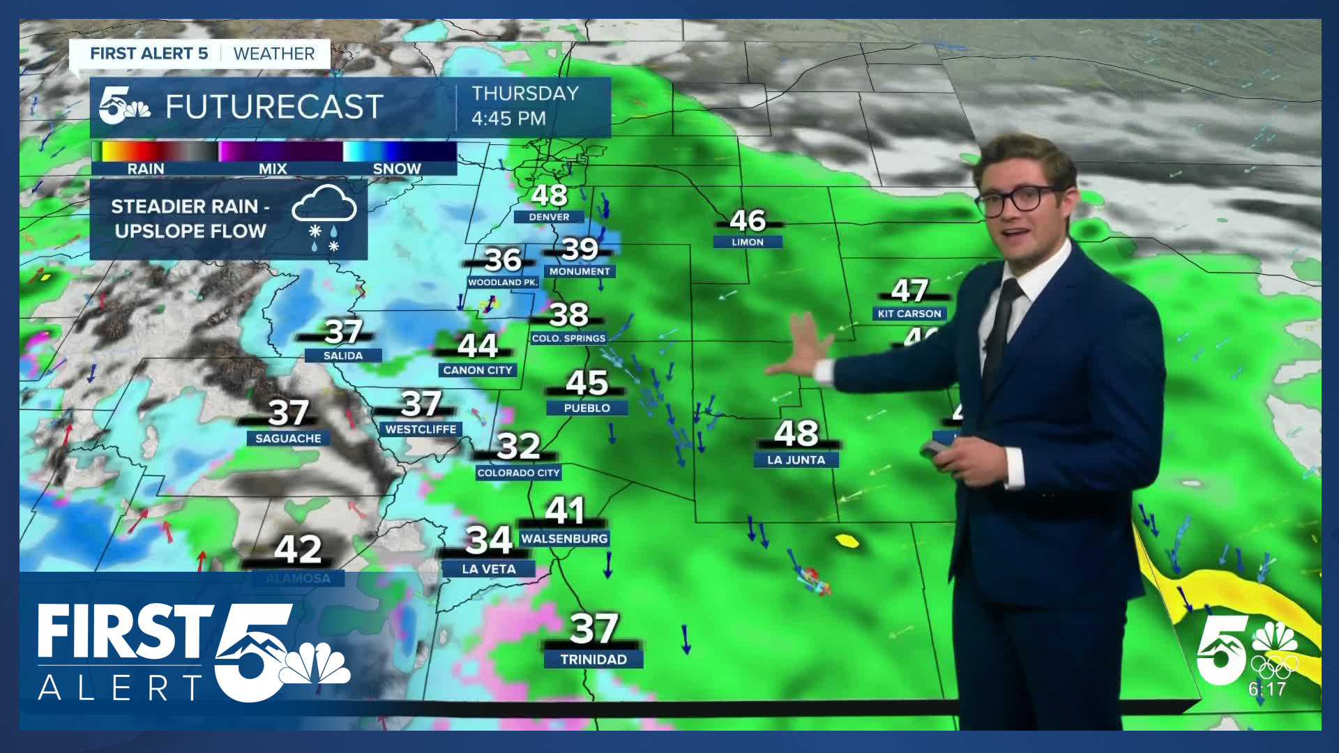
The main system arrives Thursday. On Thursday morning, I expect us to see patchy snow showers in the mountains, and rain over the southeastern plains. Heading later into the morning, we'll begin to see upslope flow develop into the I-25 corridor, which will lead to steadier rain by the afternoon. The snow level should be up near 8,000 feet during the day, resulting in snow in places like Woodland Park and Monument, but it will drop heading into the late afternoon. By evening, I expect a wintry mix and eventually a transition to snow for the Pikes Peak Region with the snow level dropping to around 6,000-6,500 feet. Showers will continue overnight into Friday morning before wrapping up.
Temperatures won't be particularly cold with this storm, but one element I'm keeping my eye on is the potential for wet-bulbing with the system. We see this frequently with winter storms, and weather models don't do a good job at accounting for it locally. In essence, the heavier and steadier the rain rate is, the cooler the air is likely to become as some of that water evaporates into the air - cooling it down. Therefore, I do expect some impacts to the Friday morning commute that are elevation dependent. One of the biggest question marks in my mind right now is how things evolve Thursday afternoon. Right now, the models keep mainly rain in the Pikes Peak Region. If that happens, total accumulations of snow will be low as the bulk of the moisture will move through before the transition. But, that wet-bulbing potential, means we can't rule out an earlier transition to snow. If that happened, we'd see some impacts to the Thursday evening commute. For now, this is too close to dial in the forecast there - so we'll keep you updated. I'm less concerned about that issue in Pueblo - the lower elevation is not favorable for you to see accumulating snow Thursday.
Showers will wrap up Friday, and it will be a bit breezy behind the system with below average temperatures. Dry skies return this weekend with mainly sunny conditions and highs rebounding to average (40s/50s).
____
Curious about the First Alert 5 Weather Storm Impact Scale? Check out our cheatsheet explainer.
Watch KOAA News5 on your time, anytime with our free streaming app available for your Roku, FireTV, AppleTV and Android TV. Just search KOAA News5, download and start watching.
