

Today’s Forecast:
Colorado is delivering some classic April weather today with a blend of fire danger, snow, rain, wind, and cold air.
A powerful cold front is crossing the state this morning and has moved through El Paso County. Behind the front, we're tracking gusty winds and quickly cooling temperatures. Early this morning, temperatures in Colorado Springs were in the mid-50s. Behind the powerful front, they've plummeted to the 30s. And with the wind, it feels like the 20s. Grab a winter jacket out the door, along with the rain gear! High temperatures have already been reached for the day although we will warm up again early this afternoon to the 40s.
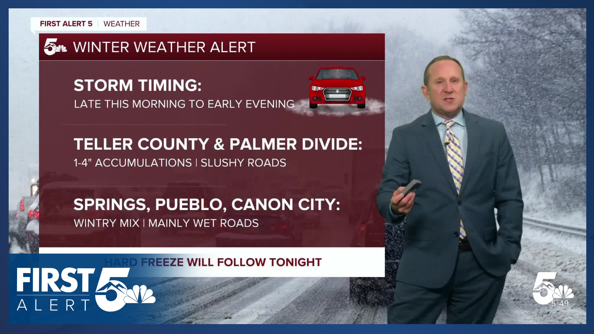
Upper-level energy pivoting through Utah will reach Southern Colorado by the lunch hour today. Between 11 AM-3 PM, we'll see snow showers develop across the Pikes Peak Region. The Palmer Divide is in the most favorable position for snow in this set up, and a rumble of thunder is possible too. Snow showers will wrap up after the evening commute. Expect 0-2" in Colorado Springs, and 1-4" in Monument (more may fall, but will struggle to accumulate).
Due to road temperatures, snow that does fall is likely to collect on grassy surfaces. Monument Hill could get a decent amount of snow, but much of it won't be able to accumulate beyond slush outside of any period of heavier snow. In Teller County, expect winter driving conditions early tonight.
Colorado Springs forecast: High: 48; Low: 21. After warming into the 70s on Thursday, today's forecast will look and feel very different. This morning's cold front has initiated the change and it will be much colder when head out for the day. Gusty northerly winds will stick around much of the day, with rain and snow showers developing around the lunch hour, wrapping up by early this evening. Snow shouldn't stick to the roads, but a few inches will be possible on grassy surfaces, cars, etc.
Pueblo forecast: High: 55; Low: 22. Temperatures today will be around 25-30 degrees colder than yesterday and that's only part of the story. A well advertised storm will bring rain, with a changeover to a wintry mix into the afternoon hours, wrapping up this evening. Any accumulations would be light, mainly on grasses and rooftops.
Canon City forecast: High: 55; Low: 25. It's been a mild start for our early risers, but a cold front advancing southward this morning will quickly change that, dropping highs into the afternoon hours. Also this afternoon, storm energy coming out of Utah will bring rain and showers to our forecast, with amounts expected to be
Woodland Park forecast: High: 42; Low: 12. Cold air punching into the state today is just the beginning of some significant weather changes on the way over the next 12-24 hours. Snow will begin to pick up late this morning and should wrap up early this evening. While we see the potential for 1-3" of snow today in Woodland Park, we think that the higher amounts could fall just east of you.
Tri-Lakes forecast: High: 30s/40s; Low: 10s. Morning commutes will be nice and mellow, but as snow moves in around the lunch hour (or sooner!), roads will become slick and slushy. The most impactful weather conditions will be from early this afternoon into your Friday evening. Snow totals from 1-4", with locally higher amounts possible, especially west of I-25.
Plains forecast: High: 50s/60s; Low: 20s. The Plains will mainly see wind and cooler temperatures today as the bulk of today's moisture is expected to remain closer to the mountains and I-25. Rain and snow showers will be possible this afternoon and evening, mostly north of Highway 50, with snow accumulations not expected on the southeastern Plains.
Walsenburg and Trinidad forecast: High: 60s; Low: 20s. The track of today's storm won't be super favorable for snow impacts south of Highway 50, with only trace amounts possible around Walsenburg this afternoon. The wind will be the bigger story instead here, with W/NW wind gusts around 40-50 mph.
Mountains forecast: High: 30s/40s; Low: 10s. The track of today's storm also won't be favorable snow in the southeastern mountains. Any accumulations today should be light, mainly under 1". Much like areas to our east, the wind will be the bigger story today, with gust in the 50-60 mph range.
Extended outlook forecast:
A Freeze Warning is in effect from 10:00 PM tonight through 8:00 AM Saturday, region-wide across much of Southern Colorado. Temperatures tonight fall to the 10s and 20s. Protect or bring inside any sensitive plants and drain your sprinkler systems.
Post frontal air remains in place Saturday so highs will be in the lower 50s in Colorado Springs and upper 40s in Woodland Park. A Freeze Watch is in effect Saturday night to Sunday morning.
We warm up Sunday with downslope flow, returning to the 70s on the Plains. That warming trend continues as upper-level ridging returns early next week and highs reach the upper 70s and 80s through the middle of next week.
____
Curious about the First Alert 5 Weather Storm Impact Scale? Check out our cheatsheet explainer.
Watch KOAA News5 on your time, anytime with our free streaming app available for your Roku, FireTV, AppleTV and Android TV. Just search KOAA News5, download and start watching.
