

Today’s Forecast:
It was a warm one on Monday, but as a word of caution, today will be quite different! Last night's strong cold front will leave us feeling the chill on Tuesday, with highs on the Plains only warming into the 40s and 50s. Highs in Teller County will top out in the 30s on Tuesday.
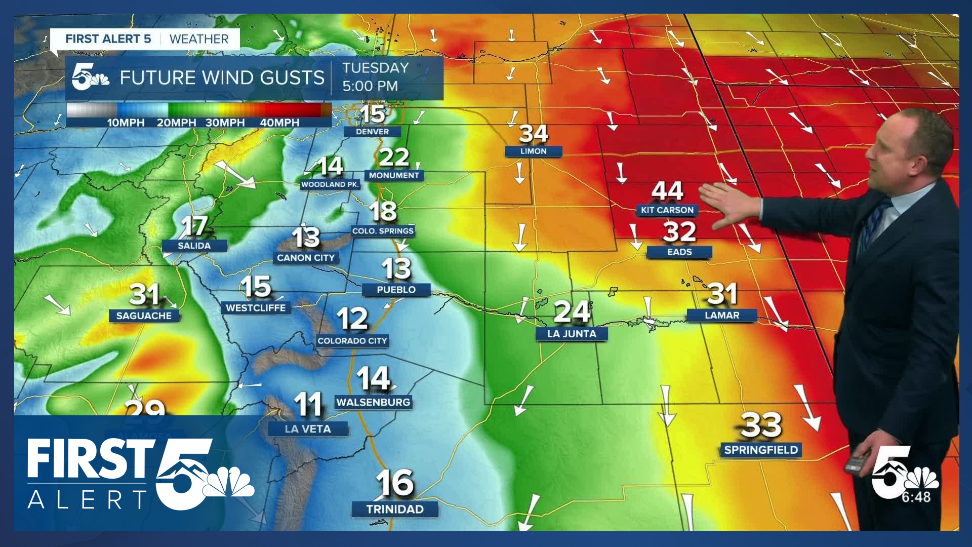
It will also be windy on Tuesday, with northerly wind gusts during the day up around 20-30 mph for the urban corridor. Stronger gusts of 40-45 mph will be possible today on the eastern Plains and in the higher terrain.
Colorado Springs forecast: High: 47; Low: 20. After a high of 73 degrees on Monday, today's high in the upper 40s may come as a shock to the system. It will also be windy on Tuesday, with gusts around 20-30 mph.
Pueblo forecast: High: 53; Low: 19. Last night's cold front will bring a dramatic shift to our weather today, with highs in the 50s and northerly wind gusts to 30 mph.
Canon City forecast: High: 51; Low: 22. Highs today in the lower 50s will be followed by a low in the lower 20s tonight. This has prompted a Freeze Warning in eastern Fremont County, with the cold expected to put an end to the growing season.
Woodland Park forecast: High: 39 Low: 19. Cold air will really make its presence felt on Tuesday as highs only warm into the upper 30s. Northerly wind gusts to 30 mph will add to the cold as wind chill temps may stay below freezing most of the day.
Tri-Lakes forecast: High: 30s/40s; Low: 10s. Tuesday's forecast will feature the coldest air of the season so far, with highs in the upper 30s and lower 40s, and lows tonight in the teens.
Plains forecast: High: 50s; Low: 20s. Monday's warm weather will give way to a much cooler and still windy day on Tuesday. Peak northerly wind gusts today could top 45 mph in some areas.
Walsenburg and Trinidad forecast: High: 40s; Low: 10s/20s. Breezy and cooler weather on Tuesday will be followed by the coldest air of the season tonight as lows drop all the way down to the teens in some spots.
Mountains forecast: High: 30s; Low: 10s/20s. Sunshine will return this morning, but it won't help to warm us up much on Tuesday as highs only warm into the 30s. Northerly wind gusts to 40 mph will be blustery during the day, with weakening wind this evening.
Extended outlook forecast:
A hard freeze will follow this evening as overnight temperatures across Southern Colorado tumble down to the teens and 20s by early Wednesday morning. Afternoon highs will be allowed to moderate by a few degrees on Wednesday, rebounding into the 50s.
Warmer highs in the 50s and 60s on Thursday will give way to a modest cool down on Halloween. Halloween night will be dry and chilly this year, with temps in the 50s at 5 pm before dropping down to the 40s after sunset.
High pressure will return this weekend, pushing highs into the 70s in many areas by Sunday.
____
Curious about the First Alert 5 Weather Storm Impact Scale? Check out our cheatsheet explainer.
Watch KOAA News5 on your time, anytime with our free streaming app available for your Roku, FireTV, AppleTV and Android TV. Just search KOAA News5, download and start watching.
