


Disclaimer: This is sponsored content. All opinions and views are of Monarch Mountain and does not reflect the same of KOAA.
Winter has not been off to a strong start on Colorado's ski slopes. Last weekend's winter storm was the first major snow event of the season - but that was all it took for most resorts to open significant new terrain.
I spent Sunday at Vail, and Monday at Keystone this week, right after the storm. Sunday still presented some decent powder snow on ungroomed runs.
WATCH: How Keystone Resort snowmakers are opening new terrain despite dry conditions
By Monday, more runs were returning to their more characteristic icy state that has defined the early season this year. Wind throughout this week has been out of the northwest, which means slopes facing north and west this weekend are likely to be icy as well.

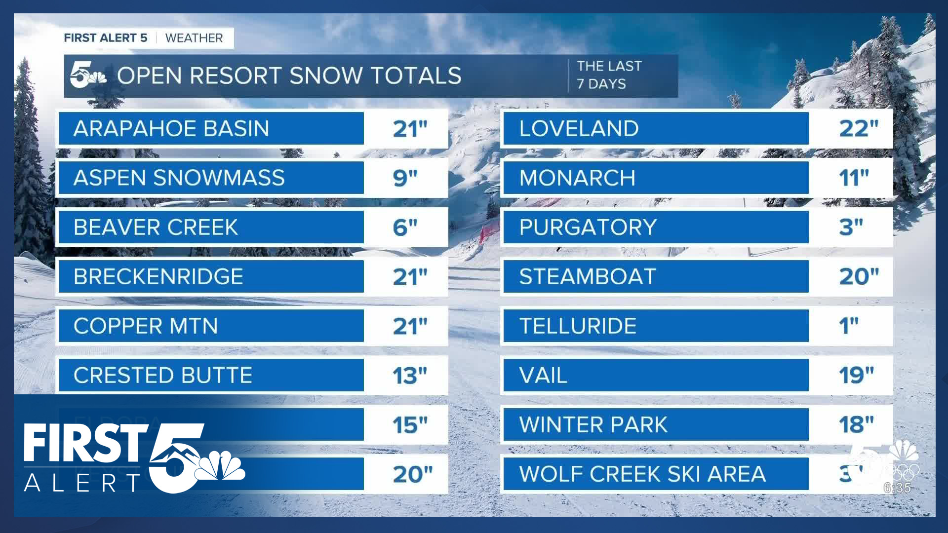
Snow totals for the resorts clustered along I-70 were in the 15-22" range in the last 7 days. This includes both weekend snow, a few inches at select resorts from an earlier weaker impulse of energy on Friday, and few widely scattered snow showers throughout this week (mostly providing 1" daily totals). Resorts in the San Juans didn't fare as well from last weekend's snow. Northwest flow doesn't favor those mountains, and they only saw a few inches.

Despite the lack of recent snow, Wolf Creek is the first resort this season to open all of their terrain. They have the highest base depth in the state, and are second to Loveland Ski Area for total snow so far this season, at 58". Despite those numbers - their base depth remains below average for the date, as do all resorts.
Monarch has also opened more terrain - with the entire Frontside, and Panorama Ridge, open.
Wind has been the theme of the week - and it remains the theme this weekend, though it's on a weakening trend as the core of the jet stream lifts north as an upper level ridge noses east into the state.

It will still be gusty on Friday, especially in the northern Front Range, but much less so than earlier in the week, and last weekend.
Winds decrease further Saturday - it'll be breezy, particularly early in the ski day.
And they look quite light Sunday as the state sits squarely under the ridge - providing subsidence, sunshine, and pleasant conditions.

Expect above average temperatures through the weekend due to that ridge - so, more than usual, higher elevation resorts are going to provide slightly better ski consistency, especially if you're a solid carver. Overnight conditions should generally stay cold and dry enough to support ongoing snowmaking operations to keep us rolling until this pattern changes again.
__
Watch KOAA News5 on your time, anytime with our free streaming app available for your Roku, FireTV, AppleTV and Android TV. Just search KOAA News5, download and start watching.
