

Today’s Forecast:
It's very mild early this Friday morning with early morning temperatures in the 40s and 50s across the Pikes Peak Region due to ongoing downslope winds that have continued overnight. A light jacket is all you'll need when you head out for the day.
With more downslope wind in the cards, we're going to once again get quite warm today, with afternoon highs in the 70s and lower 80s on the Plains. Highs today in Teller County and our mountain valleys will warm into the 60s.
Red Flag Warnings are back today due to the ongoing blend of dry and warm air, dry fuels, and gusty wind. Today, they're in effect from 11:00 am - 8:00 pm. Today's winds will be out of the west at 15-25 mph, gusting 35-45 mph. These winds are just a bit weaker than yesterday. This is the 9th day this month with Red Flag Warnings in some portion of Southern Colorado...13 days in.

Colorado Springs forecast: High: 71; Low: 41. The wind has remained gusty this morning across the Pikes Peak Region, keeping morning temperatures in the 40s and 50s. A brief break in the wind is possible around sunrise before the wind once again increases this afternoon. Red Flag Warnings will remain in effect today from 11 am to 8 pm, with peak gusts around 35 mph.
Pueblo forecast: High: 78; Low: 38. Friday's forecast will remain on the windy side, pushing highs into the upper 70s. Today's record high for context is 80°F, and was last set in 2003. With the wind dropping humidity into the single digits, Red Flag Warnings will return for the second day in a row for Pueblo County.
Canon City forecast: High: 75; Low: 44. Much like our friends on the I-25 corridor, the Arkansas River Valley will see a warm and windy Friday, with a Red Flag Warning in effect from 11 am to 8 pm. Peak gusts today could top 40 mph.
Woodland Park forecast: High: 61; Low: 35. Unseasonably warm weather on Friday will be driven by a strong westerly wind. This will dry out the air quickly this afternoon, leading to a Red Flag Warning for Teller County.
Tri-Lakes forecast: High: 60s/70s; Low: 30s/40s. If you weren't paying attention, you wouldn't know that it was March today based on our weather. Our forecast today will be warm and windy, with a Red Flag Warning in effect from 11 am to 8 pm.
Plains forecast: High: 70s/80s; Low: 30s. Much like the rest of Southern Colorado, the High Plains can expect to see more wind and dry air on Friday, resulting in a Red Flag Warning from 11 am to 8 pm. It will also be warm again today, with 80s possible in some areas.
Walsenburg and Trinidad forecast: High: 70s; Low: 30s/40s. Today's forecast will be warmer than yesterday, but otherwise, a near carbon copy due to more wind and high fire danger threats. Red Flag Warnings will go into effect today at 11 am, expiring at 8 pm.
Mountains forecast: High: 40s/50s; Low: 20s/30s. Today's Red Flag Warnings will be more widespread than what we saw earlier in the week. Because of the persistence of dry air, and with a forecast of stronger wind on Friday, even the mountains will be under a Red Flag Warning on Friday.
Extended outlook forecast:
The Saint Patrick's Day Parade is tomorrow. Many of our News5 crew will be at the event. Please come and say hello!
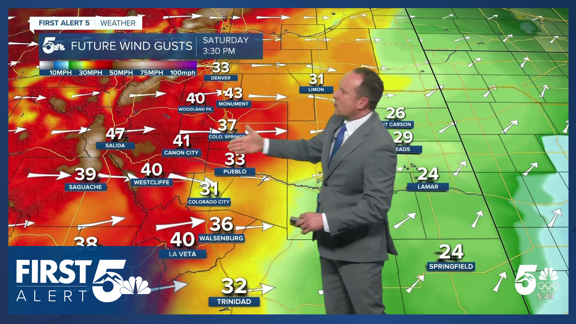
Energy moves in from the north on Saturday and that'll bring in stronger winds. This will be our gustiest day of our current multi-day fire weather setup. Areas west of I-25 may gust above 50 mph in the afternoon, with gusts to 45 mph east of I-25 in the afternoon. We'll be near record highs Saturday due to the strong downslope wind - with Saturday's record at 75 in Colorado Springs. Saturday is a higher-end fire danger set up day.
In typical Colorado fashion, a cold front blasts in early Sunday - a system coming in from the Gulf of Alaska - and that brings in snow early Sunday morning. We don't expect a lot of snow with this event - on the order of 1-2" between the Palmer Divide and Colorado Springs, with the "higher" totals over the divide, lower south under strong northerly flow. The blast of cold air will keep highs down in the 30s and 40s on Sunday and it will be very windy all day. This means the snow in the morning hours will be wind-driven, and could produce visibility impacts. Wind gusts to 50 mph are possible.
We'll moderate our temperatures Monday under partly cloudy skies with highs in the middle 50s in Colorado Springs - and lighter winds.
Then we track the big time heat! We've been advertising this for about a week now, and friends...the signal remains unprecedented for lack of a better word. We're likely to see statewide high temperature records fall across the board next week. Expect highs in the 80s in Colorado Springs late next week. Pueblo and parts of the southeastern Plains could easily crack the 90s!
____
Curious about the First Alert 5 Weather Storm Impact Scale? Check out our cheatsheet explainer.
Watch KOAA News5 on your time, anytime with our free streaming app available for your Roku, FireTV, AppleTV and Android TV. Just search KOAA News5, download and start watching.
