

Today’s Forecast:
It's a rinse and repeat weather day today in Southern Colorado - and across the state - which is not great news given yesterday's conditions. A secondary jet stream maximum will move overhead today. This maximum is not quite as strong as Tuesday's, but it's still relatively potent. It's being driven by upper-level low pressure pivoting east toward Utah. There's plenty of moisture with that low - and that's driving more snow into the mountains, where it has been desperately needed. But, this does mean mountain travel will continue to be treacherous.
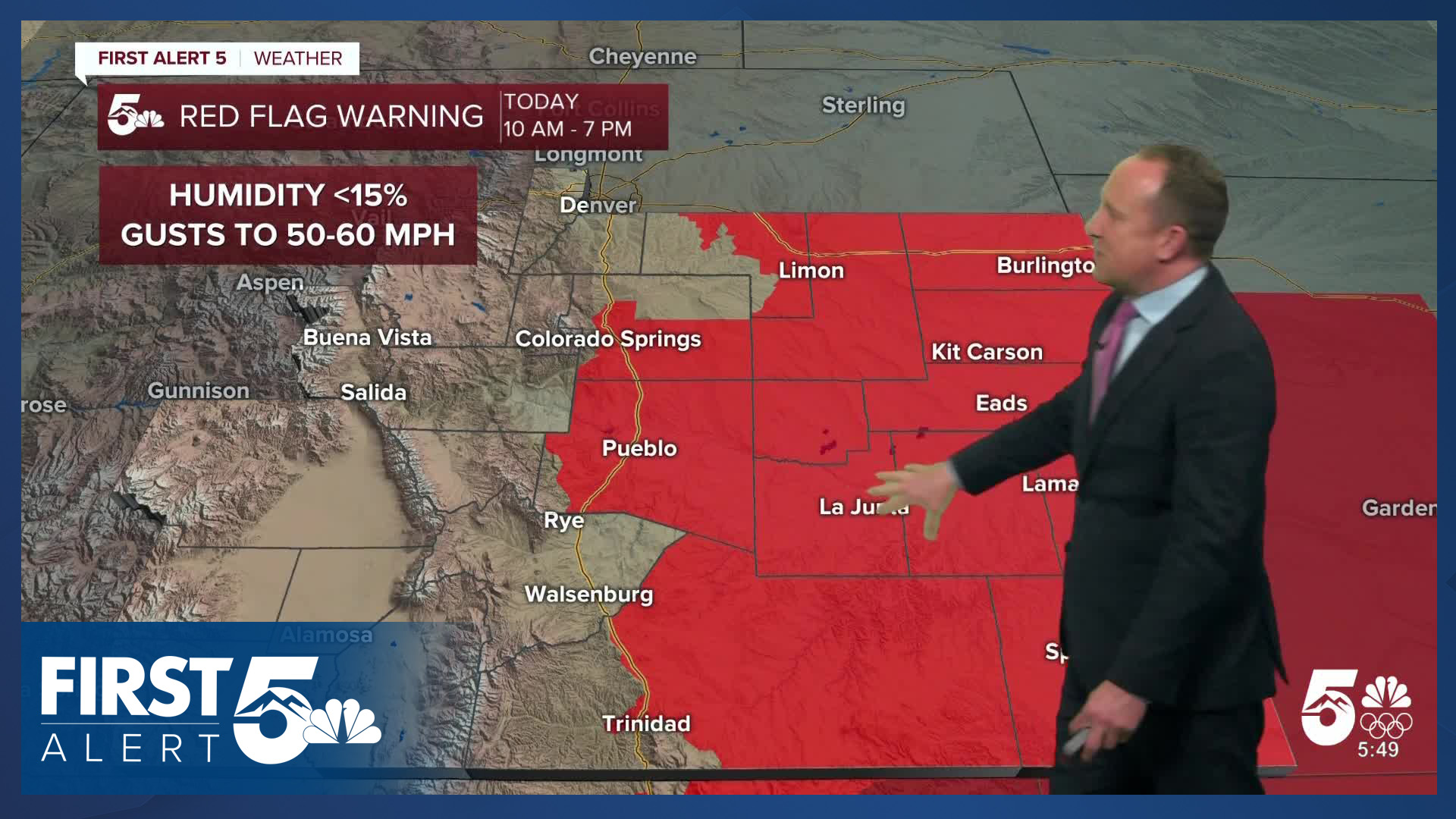
Here in southeast Colorado, we remain on the dry and windy side of this pattern. Red Flag Warnings will be in place for southern El Paso county today from 10:00 AM - 7:00 PM. We're starting off with a break in the wind this morning leading to cooler out the door temperatures. The wind won't be as strong as yesterday during the daytime, but it will still be gusty with winds of 20-25 mph from the southwest by this afternoon, gusting to 40-45 mph. It will also be very dry with humidity values below 15%. The strongest gusts will be across the upper Arkansas River Valley and southeastern mountains. These areas will be under a High Wind Warning until 7 pm.
Be prepared for more blowing dust today in the Pueblo area where the winds will be stronger. Treat low visibility conditions the same way you'd treat a snow squall, blizzard or fog. Slow down and pull over if you can no longer see the roadway. Most dust storms do not last for several hours: it's better to wait it out until visibility improves, and wind weakens.
The wind will reduce in the late afternoon, providing a relative lull. A cold front will sweep in tonight. Similar to yesterday's morning front, this will elevate wind significantly when it arrives. It also brings the chance for a quick burst of snow tonight - around dinner time between 5-8 PM in the Pikes Peak Region. Be prepared for brief visibility issues.
A High Wind Watch is in place for the Pikes Peak Region this evening, from 8:00 PM-7:00 AM. This reflects mountain wave potential behind the cold front, with those conditions most likely -west- of I-25.
Continue to avoid activities that could start a wildfire, and report any smoke to 911.
Avalanche warnings are also in place in the mountains.
Colorado Springs forecast: High: 51; Low: 21. Although wind gusts will be tampered down a few notches from yesterday, an overall windy and dry pattern on Wednesday will lead to more high fire danger threats. A Red Flag Warning will remain in effect today from 10 am to 7 pm, with peak gusts this afternoon around 40 mph. A strong cold front will arrive early this evening, increasing the wind and bringing the potential for a quick burst of intense snowfall.
Pueblo forecast: High: 59; Low: 23. Highs in the upper 50s and a lot of wind on Wednesday will make for another active weather day in Pueblo County. A Red Flag Warning will remain in effect today from 10 am until 7 pm, with a High Wind Warning in effect until 7 pm. Peak gusts today could top 60 mph in some areas, with a cold front tonight bringing us a slight chance for snow.
Canon City forecast: High: 54; Low: 25. Windy and dry during the day, with both a Red Flag Warning and High Wind Warning in effect until 7 pm. A cold front looks to arrive just before sunset tonight, with a quick burst of snow possible in Fremont County.
Woodland Park forecast: High: 40; Low: 11. More strong W/SW wind will rip across Teller County on Wednesday, with the wind picking up after 10 am. Gusts today could top 50 mph. A cold front will sweep across Teller County late this afternoon, leading to more strong wind and a quick burst of snow. Up to 1" of accumulation will be possible.
Tri-Lakes forecast: High: 40s/50s; Low: 10s/20s. Although we won't see any warnings today for northern El Paso County, our weather will remain windy. Gusts during the day could top 45 mph, with gusts tonight to 55 mph. Also tonight, a chance for a quick shot of intense snow, with up to 1" of accumulation.
Plains forecast: High: 50s/60s; Low: 20s. Windy, with high fire danger returning to the Plains on Thursday. A Red Flag Warning will remain in effect today from 10 am until 7 pm. Although the wind won't be as ferocious as yesterday, peak gusts could still top 50 mph.
Walsenburg and Trinidad forecast: High: 40s/50s; Low: 10s/20s. High Wind Warnings have been issued again today for the southern I-25 corridor, and will remain in effect until 7 pm. A Red Flag Warning has also been issued for central and eastern Las Animas County, but not Huerfano County. Peak gusts today could top 60 mph, strongest near the eastern mountain slopes.
Mountains forecast: High: 20s/30s; Low: 0s/10s. High Wind Warnings will remain in effect in the southeastern mountains on Wednesday, with peak gusts to 75 mph. Travel over high mountain passes will be impacted by wind and blowing snow. Fresh snow will also fall today, heaviest for areas along the Continental Divide. For the Wets and Sangres, we're expecting 1-3" of new snow through this evening. Heavy snow and wind will also impact the San Juans, with a Winter Storm Warning in effect for the Wolf Creek Pass.
Extended outlook forecast:
Thursday brings yet more fire and wind concerns. A Fire Weather Watch is in place Thursday for Colorado Springs, the southern I-25 corridor, and Fremont County. It will be colder following this evening's front - with highs only reaching the 40s on the Plains. Still, it will be dry and breezy with westerly winds at 15-30 mph gusting to 40 mph in the afternoon and humidity between 12-15%. Snow showers in the mountains will largely have wrapped up temporarily, though a few snow squalls remain possible mainly west of the Continental Divide.
Friday brings in another system, bringing in yet more mountain snow. As a surface low passes into the southeast plains in the afternoon, snow showers become possible in the Pikes Peak Region. Amounts look low - currently about 1". We're watching the track of this surface low closely. If it were to tick about 30 miles farther north, Colorado Springs would get better upslope flow, and that would increase the snow totals. For now though, the trend has actually been a bit southward. Either way, the upslope leads to a chilly day and more moisture in the air so fire danger will finally go down.
Saturday will remain cool with highs in the 30s and 40s region-wide, with weaker winds and mainly sunny skies. Sunday may be slightly warmer but a weak boundary will also provide more upslope flow - expect partly cloudy skies, highs in the 40s to low 50s on the Plains.
High pressure will build in early next week leading to a warmup Monday and Tuesday. By mid-week, the next potential wind and snowmaker will approach Colorado.
____
Curious about the First Alert 5 Weather Storm Impact Scale? Check out our cheatsheet explainer.
Watch KOAA News5 on your time, anytime with our free streaming app available for your Roku, FireTV, AppleTV and Android TV. Just search KOAA News5, download and start watching.
