

Today’s Forecast:
You might actually need to dig out your winter jacket from the closet this morning - following last night's cold front you're walking outside to temperatures in the 30s in many areas! These temperatures are 15-20 degrees cooler than yesterday. We've fallen to the freezing mark at the Colorado Springs Airport for the first time since Sunday. For reference, the average low today in Colorado Springs is 26. Pueblo's average low this time of the year is also 26 degrees.
The main things you'll notice today are lighter winds region-wide, and cooler temperatures. After starting in the 30s, temperatures will only climb into the 40s and lower 50s this afternoon as the post-frontal airmass lingers across Southern Colorado. This will feel chilly compared to yesterday's highs in the upper 60s and 70s.
Colorado Springs forecast: High: 48; Low: 27. We'll see a break from the wind and warmth on Wednesday as highs tumble down to the upper 40s in Colorado Springs. Tonight will be our coldest night since this past weekend as drop down to the upper 20s.
Pueblo forecast: High: 52; Low: 23. After warming into the upper 70s on Tuesday, our high this afternoon in the lower 50s will be one of the coolest days of the month so far in Pueblo.
Canon City forecast: High: 52; Low: 29. A rare, cooler day is ahead for eastern Fremont County, with our highs today only warming into the lower 50s. Temperatures will drop below freezing tonight, cooling down to the upper 20s.
Woodland Park forecast: High: 45; Low: 25. Temperatures will be much cooler today compared to how the week began, but the cool down won't last long, with a return to upper 50s and 60s during the second half of the week.
Tri-Lakes forecast: High: 40s; Low: 20s. Wednesday's cool down will be brief, so enjoy it. Highs today will top out in the middle to upper 40s before returning to the 60s and 70s late this week.
Plains forecast: High: 40s/50s; Low: 20s. It has been a windy start to our Wednesday on the High Plains, and the wind will remain gusty while shifting to the E/NE later this afternoon. Highs will be relatively cool today, with highs rebounding by as much as 20-25 degrees tomorrow and Friday.
Walsenburg and Trinidad forecast: High: 40s/50s; Low: 20s/30s. Cool, northerly winds this morning will turn southerly into the afternoon, but should be lighter than the past couple of days, with peak gusts to 25 mph.
Mountains forecast: High: 40s/50s; Low: 10s/20s. Dry skies and relatively warm air compared to the Plains will mean that today's high fire danger threats will focus along the San Luis Valley and upper Arkansas River Valley. Peak wind gusts in these areas this afternoon could top 45 mph. In the higher terrain, it will also be blustery on Wednesday, with gusts in the 35-45 mph range.
Extended outlook forecast:
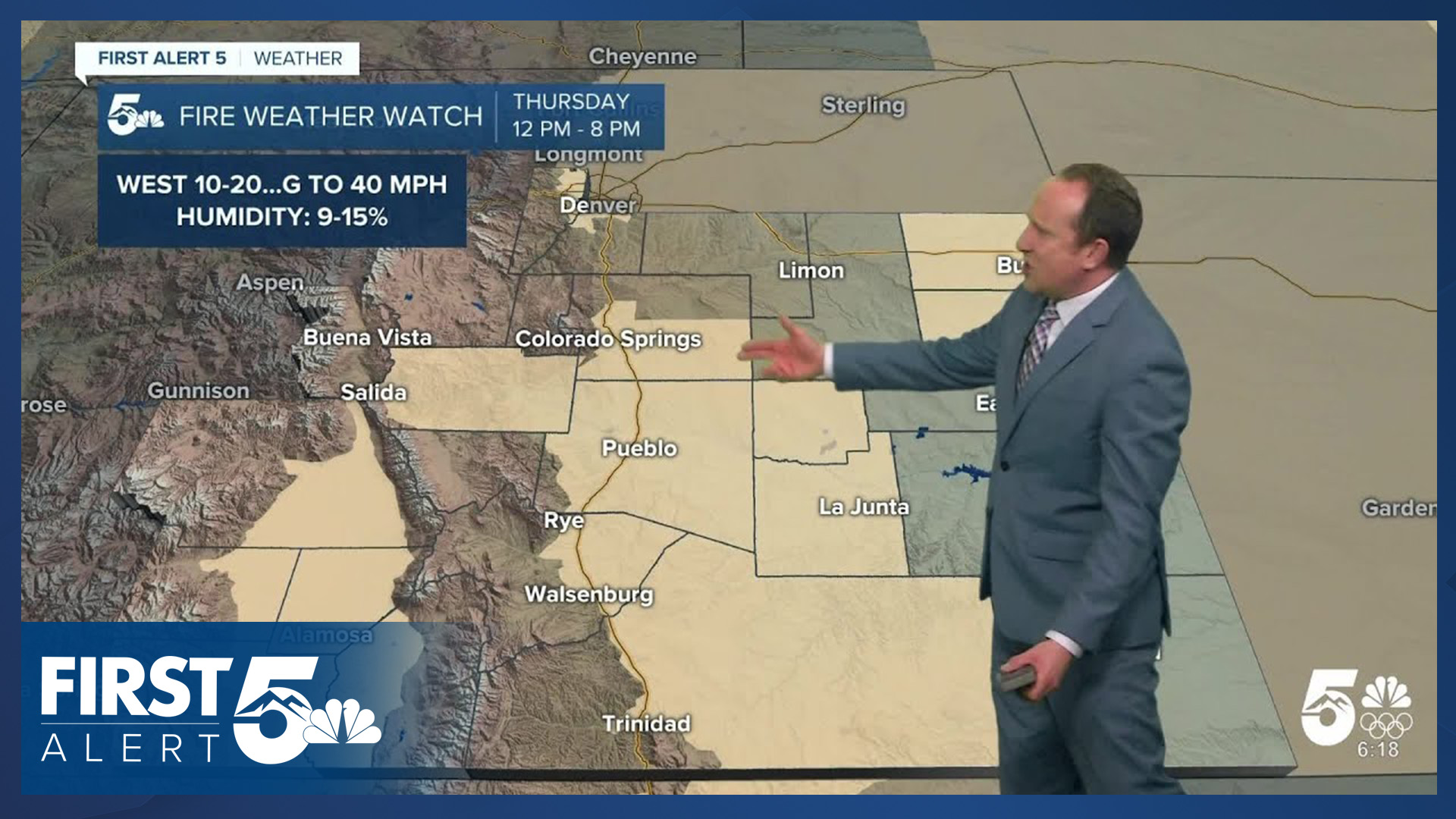
We go right back to warmth, wind, and fire danger tomorrow. In fact, highs the next several days will be near records. The record high Thursday is 72, on Friday it's 74, and Saturday - 75 in Colorado Springs. A northwesterly jet stream will be just north of the state, with some of that wind energy spilling into Colorado.
The strongest wind tomorrow will be in the northern mountains, with gusts around 80-100 mph west of Denver. In the Pikes Peak Region, wind speeds of 10-20 mph are likely, gusting 30-40 mph. Coupled with low humidity, Fire Weather Watches are in place Thursday from Noon - 8 PM.
Highs region-wide Thursday will warm into the 60s and 70s, with partly cloudy skies - a classic wave cloud set up day with northwesterly flow. Great for picture taking!
On Friday, there will be less energy in the middle atmosphere to mix down the wind, which means the gustiest conditions will be confined more to the mountains and slopes immediately east of them. Wind gusts of 25-35 mph are still possible - they'll be a bit more come-and-go than on Thursday, but it's another elevated fire danger day with dry air and warmth. Highs will be very close to records.
Saturday is the most concerning fire day of this current batch of fire weather conditions. As the jet stream pivots to a more westerly direction across Colorado, temperatures will climb to the 70s and 80s on the Plains. It will be the gustiest day, and very dry.
A cold front arrives Sunday - it will be another cooler day. That next front may bring a few snow showers to the Pikes Peak Region Saturday night to Sunday morning. Too soon to tell how far south the snow will make it, but we'll keep you posted of those potential changes here at News 5.
____
Curious about the First Alert 5 Weather Storm Impact Scale? Check out our cheatsheet explainer.
Watch KOAA News5 on your time, anytime with our free streaming app available for your Roku, FireTV, AppleTV and Android TV. Just search KOAA News5, download and start watching.
