


Today’s Forecast:
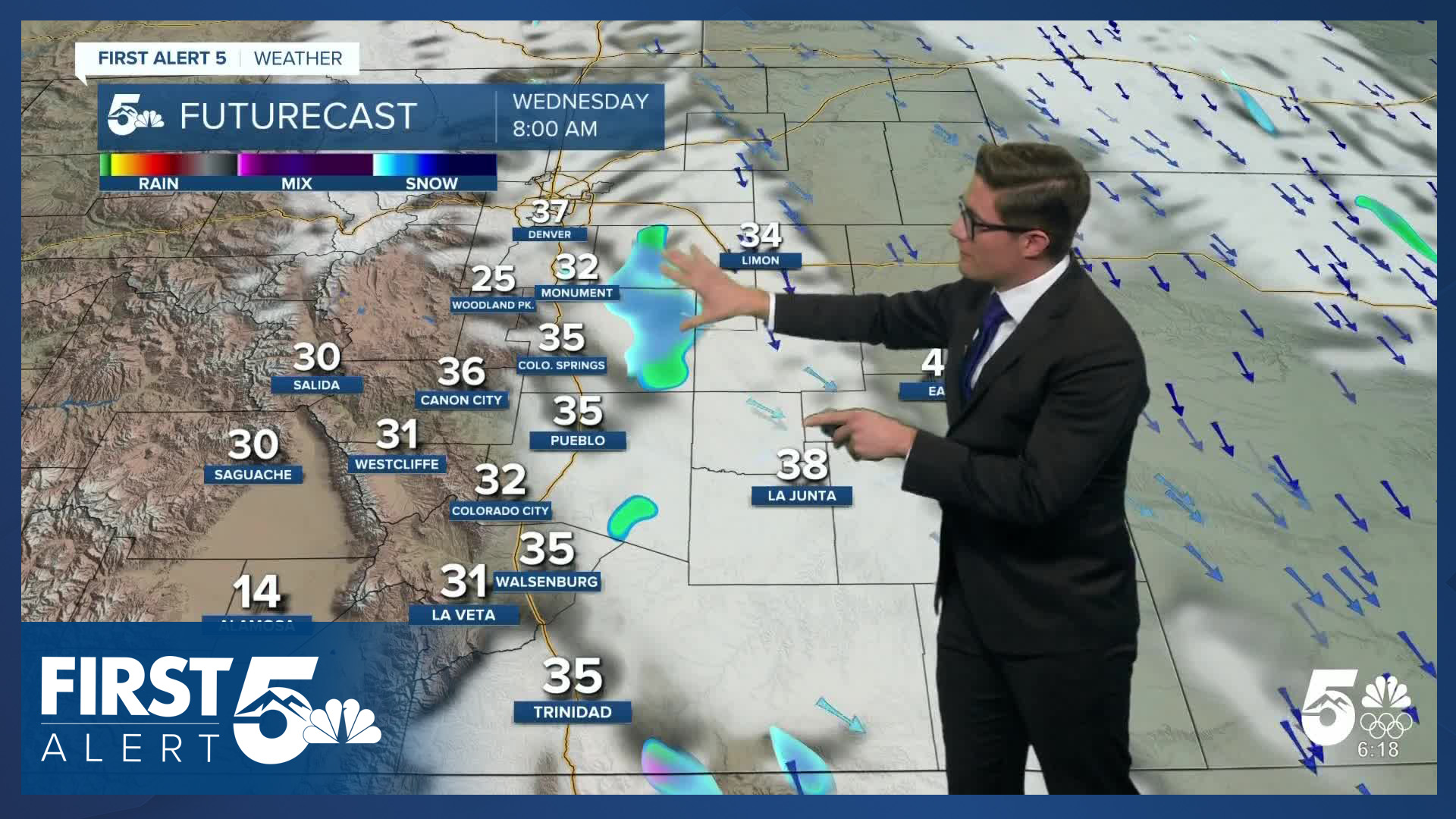
A cold front swept through southern Colorado last night, with a few light rain and snow sprinkles this morning over the eastern plains behind the front. Over the Palmer Divide, patchy fog has developed, for the rest of southern Colorado skies are mostly cloudy. The bulk of the cold air with this front is well east of Colorado, so highs today will only cool slightly compared to Wednesday. Temperatures will top out in the middle to upper 40s across most of the plains and low 50s in the Arkansas River Valley and the eastern tier. Skies begin the day overcast, becoming partly cloudy by noon, and mostly sunny by early afternoon. Mostly clear skies will persist tonight. A few sprinkles east of I-25 are possible through 9:00 AM, with very minimal impacts.
It will be breezy today. This morning the breezes will stay mainly across the Palmer Divide, eastern El Paso county, and the eastern plains. Breezes should overspread most of the Pikes Peak Region this afternoon with gusts in the 20-30 mph range, with 40 mph gusts possible over the Palmer Divide. Tonight, winds will begin to shift out of the northwest.
Colorado Springs forecast: High: 48; Low: 29.
AM clouds decreasing through the day becoming mostly sunny this afternoon. A few degrees cooler today thanks to last nights cold front, with north winds at 10-15 mph, with periodic stronger gusts this afternoon that you'll notice but won't be too big of a deal.
Pueblo forecast: High: 51; Low: 26.
Periodic clouds through the morning becoming mostly sunny and comfortable this afternoon. A notable 10 degree cool down versus yesterday with some light west winds this morning. This afternoon, northeastern parts of the city will feel some northerly breezes kick up, but most of the city will see light wind and it will be very comfortable for outdoor plans.
Canon City forecast: High: 52; Low: 31.
Partly cloudy becoming mostly sunny with morning westerly winds that should be fairly weak shifting north this afternoon. Overall a quiet and comfortable day.
Woodland Park forecast: High: 44; Low: 25.
Mostly sunny with north winds at 10-15 mph today in the city above the clouds. If you're hiking today, you'll continue to encounter icy/snowy patches on shaded parts of area trails.
Tri-Lakes forecast: High: 40s; Low: 20s.
Gusty today over the Palmer Divide! The AM fog should dissipate by the end of the AM commute, with skies slowly clearing out into the afternoon. Winds will increase out of the north at 15-20 mph, gusting to 30 mph at times today. It will be mostly sunny this afternoon.
Plains forecast: High: 60s; Low: 20s.
Cloudy this morning, becoming partly sunny by 11 AM and mostly sunny by 2 PM (the farther north you live, the sooner the sky clears). Gusty, mainly east of the Palmer Divide but some 30 mph gusts are possible over the eastern plains too.
Walsenburg and Trinidad forecast: High: 48/49; Low: 30/31.
Mostly sunny with northwest winds at 5-15 mph - a dry, somewhat-near-average day.
Mountains forecast: High: 40s; Low: 20s.
Mostly sunny - most mountain zones are well above the cloud deck this morning. Breezy with northwest winds at 10-20 mph, gusting to 30 mph. Tonight, winds will briefly reduce before increasing again tomorrow. Skies will remain dry.
Extended outlook forecast:
Downslope breezes will return Thursday, warming temperatures well above average again. A few wave clouds are possible, but otherwise skies should be mostly sunny. Breezes will be most notable close to the mountains. It will be dry across the region as the downslope flow dries out the air.
Another cold front will arrive Thursday night. It's coming from the same direction as the front that moved through last night, but this system is slightly further west and brings colder air closer to Colorado. Therefore, we see a bigger cooldown with this system and stronger wind gusts - which will again favor the Palmer Divide, and plains. High wind watches are in place Friday for the northeastern plains of Colorado. Highs will feel winter like: upper 30s, to low 40s, with cooler wind chills. The cool air sticks around Saturday as a reinforcing push of cold air backs into the area, and we have upslope flow for a portion of the day. Sunday will be sunny and mild.
Martin Luther King Junior day sees a bit of a cooldown to the mid 40s, but overall if you have holiday weekend plans...the forecast is dry statewide.
____
Curious about the First Alert 5 Weather Storm Impact Scale? Check out our cheatsheet explainer.
Watch KOAA News5 on your time, anytime with our free streaming app available for your Roku, FireTV, AppleTV and Android TV. Just search KOAA News5, download and start watching.
