

Today’s Forecast:
It's a cold start across Southern Colorado this Wednesday as Canadian air hovers overhead following yesterday's cold front. Temperatures are starting in the 10s and 20s, with wave clouds drifting off the mountains. Those clouds will keep temperatures cool for the first few hours after sunrise. The clouds will thin approaching the lunch hour, turning mostly sunny by the afternoon. Highs today will warm into the 40s and 50s, a few degrees warmer than yesterday.
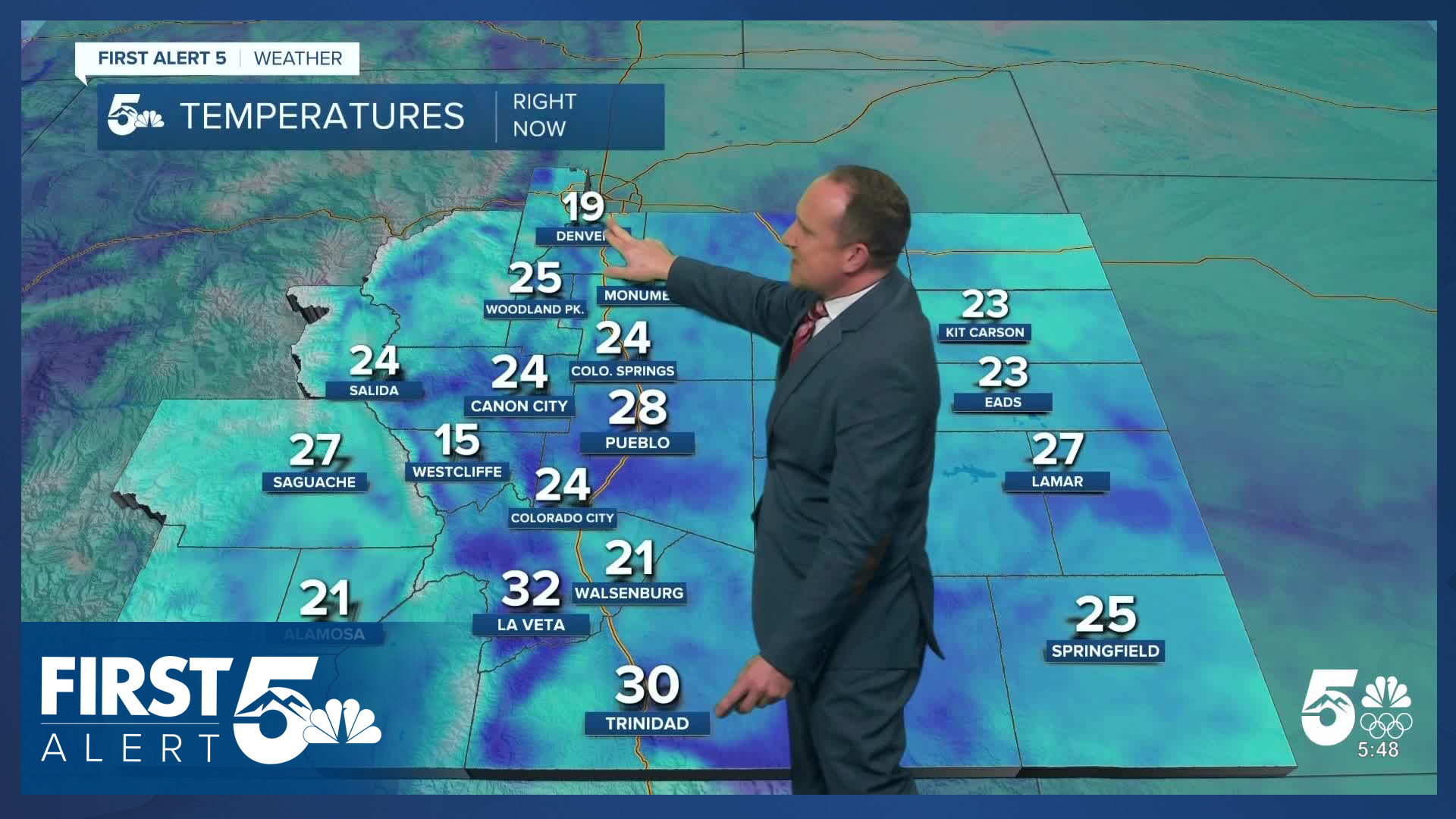
Colorado Springs forecast: High: 48; Low: 25. After a chilly and overcast Tuesday, Wednesday's weather should be brighter and slightly warmer, with our high today in Colorado Springs topping out in the upper 40s.
Pueblo forecast: High: 50; Low: 21. Whether your plans involve driving or a last minute run to the grocery store on Wednesday, the weather today will be nice, with dry skies and near average highs.
Canon City forecast: High: 53; Low: 28. A nice boost in temperatures will follow yesterday's highs in the 40s, with today's highs climbing back into the lower 50s in eastern Fremont County.
Woodland Park forecast: High: 45; Low: 22. On Wednesday, we'll see decreasing clouds, light winds, and near average highs in the 40s in Teller County. Late this week, it will be even warmer before a big pattern change this weekend.
Tri-Lakes forecast: High: 40s; Low: 20s. Dry skies and warming highs can be expected on Wednesday as temperatures climb by as much as 4-7 degrees from yesterday in northern El Paso County.
Plains forecast: High: 40s/50s; Low: 20s. The Plains will see warmer highs and mostly sunny to partly cloudy skies on Wednesday, with light SE winds this afternoon sustained around 10-15 mph.
Walsenburg and Trinidad forecast: High: 50s; Low: 20s. Some of the warmest temperatures today will be in Trinidad, with middle to upper 50s here this afternoon, and lower 50s for Walsenburg.
Mountains forecast: High: 30s/40s; Low: 10s/20s. Cloudier skies this morning, with some light snow once again in the forecast for the central and northern mountains. The Wets and Sangres aren't expecting any snow on Wednesday, but it will be breezy, with occasional gusts to 35 mph.
Extended outlook forecast:
Thanksgiving brings near average temperatures in the 40s and 50s with above average temperatures arriving for Black Friday. Thanksgiving will be mostly sunny, and Friday will be partly to mostly cloudy. Multiple batches of arctic air will push through Southern Colorado this weekend. A cold front arrives overnight Friday evening into Saturday morning. Air flow for the front locally favors a northerly direction.
The front brings a chance for snow showers and gusty wind to the area. The Palmer Divide is most favored in northerly wind setups. The gusty breezes will lead to notable wind chills Saturday tacked onto the very cold temperatures. Highs will only reach the 30s, with lows in the teens.
We'll get even colder on Sunday - climbing to only the upper 20s and lows in the teens at best. The record low Sunday in Colorado Springs is -3, set in 2006, and the record coldest high is 17, set in 1983. We are not likely to break or meet either of those. The 10th coldest low is 7 degrees, set in 1930. Art the same time, the average high Sunday is 47 and the average low is 21.
Another system will approach Sunday night, with more snow showers possible Sunday night into Monday morning. This may lead to Monday commute impacts. It will remain chilly on Monday.
We see a slight moderation in temperatures in the middle of next week.
____
Curious about the First Alert 5 Weather Storm Impact Scale? Check out our cheatsheet explainer.
Watch KOAA News5 on your time, anytime with our free streaming app available for your Roku, FireTV, AppleTV and Android TV. Just search KOAA News5, download and start watching.
