

Today’s Forecast:
Friday brings the first below average high temperature day to southern Colorado in 11 days. We have set 7 daily record highs since the first heat dome began to build across the southwestern U.S.
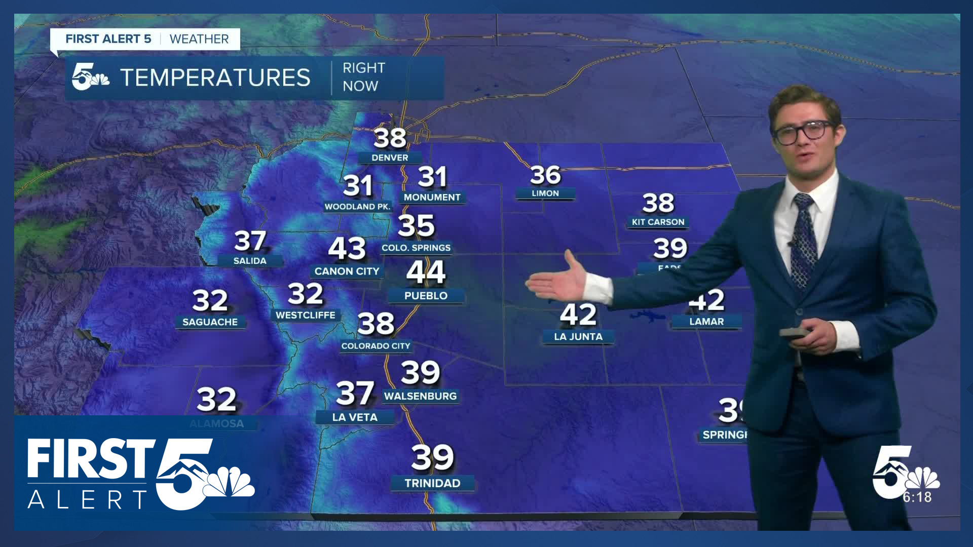
Following a cold front yesterday, today begins with mainly cloudy skies. Temperatures are in the 30s to low 40s, so grab a jacket and perhaps a light pair of gloves as you step outside. With persistent upslope flow, the clouds hang tough into the early afternoon and temperatures don't warm much. Westerly flow begins to return and mix out the clouds in the middle afternoon.
There will be continued clearing this evening for any date night plans.
Colorado Springs forecast: High: 46; Low: 30.
Mostly cloudy with low cloud bases this morning due to upslope flow - with patchy fog. Skies become mostly cloudy around lunchtime, then partly cloudy near sunset. North northeast winds this morning shifting southeasterly this afternoon. You'll need a light to mid-grade layer for much of today as temperatures won't change much before the clouds depart.
Pueblo forecast: High: 51; Low: 29.
A cool and cloudy day - perhaps a refreshing change - from the heat of the last week and a half. We'll be back to warm conditions Saturday so today is simply a blip on the radar. Skies will remain cloudy until late afternoon before turning partly cloudy before sunset. East southeast winds.
Canon City forecast: High: 51; Low: 36.
Mostly cloudy and cool with southeasterly upslope winds. The low stratus deck will be quite persistent today. Only a few peaks of sun late this afternoon.
Woodland Park forecast: High: 43; Low: 29.
Mostly cloudy for much of the day - keeping temperatures chilly. You may want to grab a light pair of gloves with your jacket today. A few light sprinkles and flurries are possible this morning, but no accumulation is expected. Skies begin to clear in mid-afternoon, with westerly winds mixing out much of the cloud layer in the last two hours before sunset.
Tri-Lakes forecast: High: 40s; Low: 30s.
Cloudy through much of the afternoon, becoming partly sunny after 2:00 PM. The clearing will be accompanied by an increase in wind speeds.
Plains forecast: High: 50s; Low: 30s.
Mostly cloudy through the afternoon, becoming mostly sunny before sunset. A relatively chilly day.
Walsenburg and Trinidad forecast: High: 48/51; Low: 34/32.
Mostly cloudy with upslope southeasterly winds. Some parts of the area will cool to freezing tonight.
Mountains forecast: High: 30s/40s; Low: 20s/30s.
Mostly cloudy with isolated morning snow showers. No accumulations with any snow showers. Winds stay upslope straight into the early evening before shifting southerly.
Extended outlook forecast:
Heat and fire danger return - again - this weekend. We'll have mainly clear skies Saturday morning with increasing afternoon and evening clouds as temperatures warm to the upper 70s in the Pikes Peak Region and lower 80s in the Pueblo area. It will be breezy in the afternoon with westerly winds. While Fire Weather Watches aren't currently in place for El Paso County or Pueblo on Saturday, burn restrictions remain in place and it will still be important to avoid activities that could start a wildfire.
We stay similarly warm on Sunday and Monday as our well-acquainted friend upper-level high pressure sits to the south of Colorado. It will be less breezy on Sunday, and more breezy again on Monday. There will be a few mountain showers Monday afternoon.
A cold front will approach on Tuesday. The first part of the day will be mild, but the front will ultimately result in a cooler day. By the evening, there will be a chance for isolated showers.
We remain unsettled in the middle of next week as multiple disturbances make their way toward the state.
____
Curious about the First Alert 5 Weather Storm Impact Scale? Check out our cheatsheet explainer.
Watch KOAA News5 on your time, anytime with our free streaming app available for your Roku, FireTV, AppleTV and Android TV. Just search KOAA News5, download and start watching.
