

Tonight's Forecast:
There will be a light downslope breeze tonight, keeping temperatures mild and about 10 to 15 degrees above average.
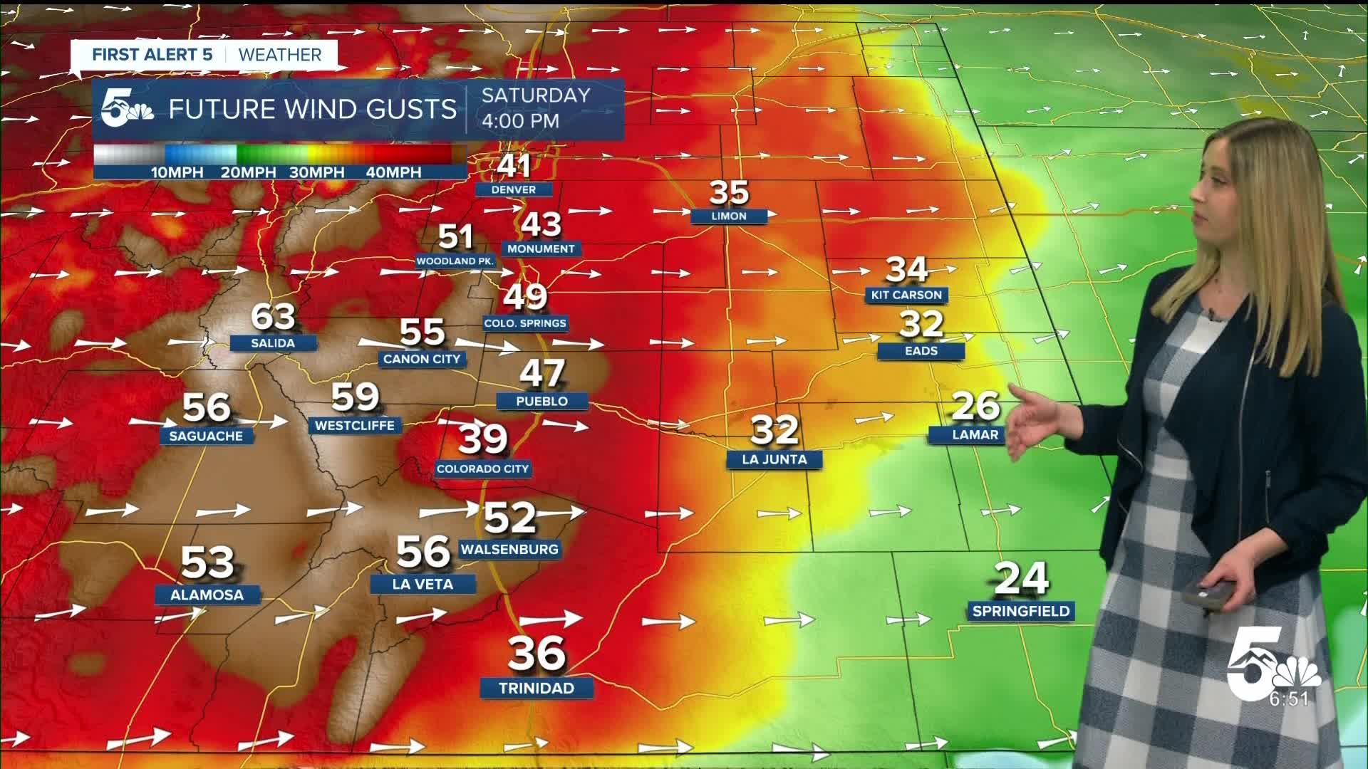
Saturday Fire Danger:
The wind cranks up on Saturday, gusting 30-50 mph in the plains, 40-60 mph in the mountains. Humidity will drop below 15%. A RED FLAG WARNING has been issued for high fire danger on Saturday from 11 am until 10 pm.

Colorado Springs forecast: Low: 41; High: 76;
RED FLAG WARNING from 11 am until 10 pm. Wind will be out of the W at 15-20 mph, gusting up to 50 mph. The temperature will be more than 20 degrees above average and may break the daily record that stands at 75.
Pueblo forecast: Low: 38; High: 81;
RED FLAG WARNING from 11 am until 10 pm. It will be windy with W wind at 15-20 mph gusting to 50 mph. Temperatures will be very warm, nearing the daily high record of 83.
Canon City forecast: Low: 44; High: 78;
RED FLAG WARNING from 11 am until 10 pm. It will be windy with W wind at 20 mph gusting to 55 mph.
Woodland Park forecast: Low: 35; High: 63;
RED FLAG WARNING from 11 am until 10 pm. It will be mild and windy on Saturday with W wind at 15-20 mph gusting to 55 mph.
Tri-Lakes forecast: Low: 42; High: 72;
RED FLAG WARNING from 11 am until 10 pm. Saturday will be warm and windy with W wind at 15-20 mph gusting to 45 mph.
Plains forecast: Low: 30s-40s; High: 70s-80s;
RED FLAG WARNING from 11 am until 10 pm. It will be very warm in the upper 70s to mid-80s. Wind will be gusty from the W at 10-15 mph, gusting 30-40 mph.
Walsenburg and Trinidad forecast: Low: 43/38; High: 74/77;
RED FLAG WARNING from 11 am until 10 pm. It will be warm and windy on Saturday with W wind at 15-20 mph gusting to 55 mph in the Walsenburg vicinity, and 40 mph in the Trinidad vicinity.
Mountains forecast: Low: 20s-30s; High: 60s;
RED FLAG WARNING from 11 am until 10 pm. It will be very windy on Saturday with sustained W winds of 20-30 mph, gusting 50-65 mph.
Extended outlook forecast:
Late on Saturday night, a strong cold front blows in, bringing strong, cold, northerly wind all day Sunday.
A HIGH WIND WATCH has been issued for Sunday, when 60-75 mph gusts are possible.

This front also brings a chance of light snow before sunrise Sunday, favoring the mountains north of HWY 50 and El Paso and Teller County. So don't be surprised if you see a dusting of snow to as much as an inch when you wake up.
After that, Monday is still chilly, but calmer. Tuesday through Friday become VERY warm, with low 80s possible late in the week!
____
Curious about the First Alert 5 Weather Storm Impact Scale? Check out our cheatsheet explainer.
Watch KOAA News5 on your time, anytime with our free streaming app available for your Roku, FireTV, AppleTV and Android TV. Just search KOAA News5, download and start watching.
