

Today’s Forecast:
We're swapping wind for cold today in Southern Colorado as a winter weather maker moves into the San Juans. It's very cold this morning and you'll need the layers. These are the coldest temperatures you've experienced so far this February. Wind chill values are in the single digits and teens this morning. Monument Hill has been experiencing wind chills near 0 this morning.
It will stay cold all day — and that's the biggest thing you'll notice with today's weather. Our highs will be in the 30s and 40s. If you're taking your dog for a walk --today's a good day for a shorter walk, or if you do plan on a longer walk, use doggy booties to protect their feet from the cold ground.
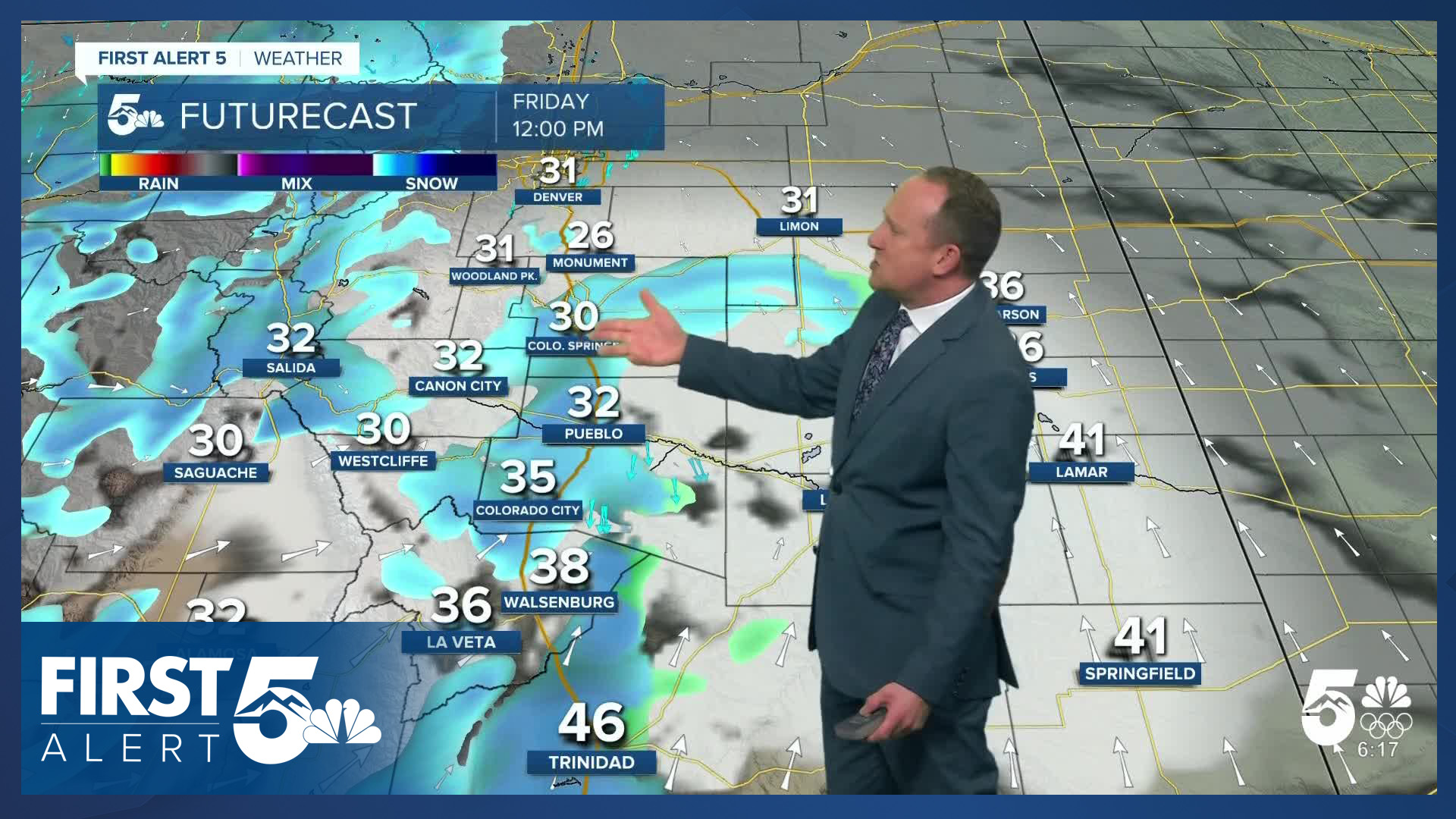
While most of the snow with this storm system will fall in the southwestern part of the state, with several inches in the central mountains and northern mountains — a bit of moisture is likely to reach us here in Southern Colorado. There will be two chances for snow today: first between 10 am and noon, and again between 2-5 pm in the Pikes Peak Region. We could see up to an inch in Colorado Springs --although it's worth noting our best performing high res model suggests a slight chance for a little more.
In Woodland Park, we expect 1-3", and 1-2" is possible over Monument Hill. These snow bursts have the potential to produce short-term visibility issues and make the roads slippery, especially in Teller County and over the Palmer Divide. If you do get caught in one of these snow bursts, treat it like dense fog: slow down, be prepared to pull over if you can no longer see the road or road markings clearly, and use caution in general.
Colorado Springs forecast: High: 33; Low: 13. The coldest storm of the month will bring periods of light snow to the Pikes Peak Region on Friday. Right now, the models are showing our best chances for snow with two separate bursts, one during the mid to late morning hours, and another this afternoon. Snow totals look light in town, around 1" or less. Some isolated higher totals will be possible.
Pueblo forecast: High: 38; Low: 12. Any light snow that we see today in Pueblo shouldn't amount to more than a light dusting, or about a half an inch of accumulation. The bigger story today will be the cold, with our highs this afternoon only warming into the upper 30s.
Canon City forecast: High: 39; Low: 16. Colder air will continue to settle into Southern Colorado on Friday, with highs this afternoon in eastern Fremont County only warming into the upper 30s. Periods of light snow will accompany today's storm, with up to 1" of accumulation possible.
Woodland Park forecast: High: 30; Low: 7. Today's highs will be even colder than yesterday. Add to that periods of snow, and it'll look and feel a lot more like February than what we saw earlier this week. With accumulations of 1-3" today, impacts to travel are possible starting this afternoon, and will continue into Saturday morning.
Tri-Lakes forecast: High: 20s/30s; Low: 10s. A few flurries this morning will give way to increasing chances for snow during the day, with the snow ending this evening. Snow totals of 1-2" are possible. Because of the cold, snow will have the potential to stick fast and quick, with possible travel impacts by this afternoon and evening.
Plains forecast: High: 30s/40s; Low: 0s/10s. Friday's forecast will be a cold one on the Plains and breezy to gusty. The strongest gusts today will be in the southeastern Plains, where some southerly wind gusts to 45 mph will be possible. Snow showers will also be tracking east this afternoon, with most accumulations expected north of Highway 50.
Walsenburg and Trinidad forecast: High: 30s/40s; Low: 10s. Windy and unsettled on Friday, with 40-50 mph wind gusts coming out of the W/SW this afternoon. On top of the wind, it will be cold, with periods of light snow. Accumulations should stay under 0.5" today.
Mountains forecast: High: 40s; Low: 20s. Travel over the La Veta Pass will be slow today, with snow covered roads only getting worse throughout the day with 2-5" of snow in the forecast. Lighter amounts of 1-3" will be possible in the mountain valleys. It will also be cold and windy today, with peak gusts to 50 mph.
Extended outlook forecast:
A brief period of low clouds, and patchy fog, is possible early Saturday morning. That should clear out relatively fast after sunrise due to downslope northwesterly winds.
Saturday will still be brisk - but sunny - as high pressure begins to rebuild. Highs will be in the lower 40s in Colorado Springs, with light winds that flip from northwest to southeast in the afternoon. It will be mostly sunny to partly cloudy on Sunday across Southern Colorado, with more weak upslope flow and highs in the 40s and 50s. Expect dry skies statewide if you're traveling.
The roller coaster of temperatures will be a steep upward climb as we begin next week. A large ridge of high pressure will build in Sunday and persists through the middle of next week. Monday warms to the 60s on the Plains. Highs will warm to 20-25 degrees above average, with the potential for record warmth on Tuesday. The record high Tuesday in Colorado Springs is 71 degrees, set in 1986. This warmth will as usual be accompanied by downslope winds, which means fire danger is likely to be high once again.
By mid-week, we'll be tracking our next potential system.
____
Curious about the First Alert 5 Weather Storm Impact Scale? Check out our cheatsheet explainer.
Watch KOAA News5 on your time, anytime with our free streaming app available for your Roku, FireTV, AppleTV and Android TV. Just search KOAA News5, download and start watching.
