


Disclaimer: This is sponsored content. All opinions and views are of Monarch Mountain and does not reflect the same of KOAA.
Colorado's ski slopes experienced a tale of two seasons this week, with some resorts thriving while others struggle with warm weather delays.
Beaver Creek and Telluride have postponed their opening dates due to unseasonably warm temperatures, joining several other Colorado resorts that have delayed their season starts. However, there have also been a few bright spots this week as conditions improve at select mountains.

Wolf Creek currently offers the best skiing conditions in Colorado, with 14" of natural snowfall in the past week allowing the resort to open approximately 80% of its terrain at the time of publication. The resort is currently the only option for black diamond terrain skiing in the state on piste.
Keystone has 10 trails open, split between beginner green and intermediate blue runs. The resort received 9 inches of snow over the past week, making it the second-best snowfall total after Wolf Creek and a good choice for skiers and riders aiming for resorts along Interstate 70.

Arapahoe Basin accumulated 7 inches of new snow, while Breckenridge continues to struggle with only 1 inch of snowfall in the last week. The Tenmile Range (which includes Breckenridge), has not had any good snows yet this season, a consequence of changes to the jet stream due to La Nina, coupled with other unfavorable large-scale atmospheric processes.
Pass sales will be ending in the next several weeks. Epic Pass sales end next week - the last day to purchase one will be December 4th. Ikon Pass sales typically conclude in early December, though no specific date has been announced.

This weekend will bring a modified arctic airmass into Colorado, bringing with it much colder temperatures than were seen over the past week, and the phasing of a pacific and Canadian storm system. That system will bring snow showers early this weekend. Northern Colorado resorts will see a significant temperature drop from Friday to Saturday, with highs in the 20s on both Saturday and Sunday: pack the layers!
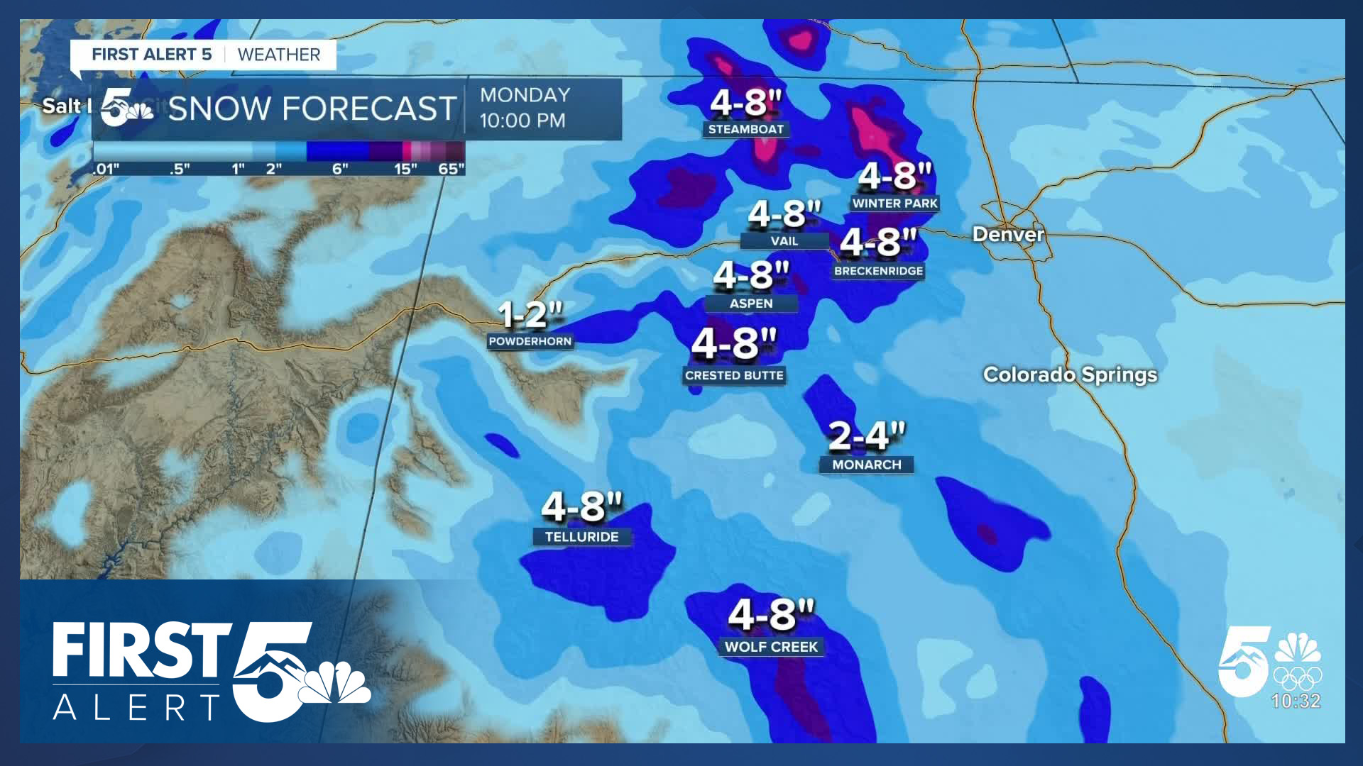
Two winter weather producing systems are approaching Colorado. The first system mentioned above will arrive Friday afternoon in the northern mountains, bringing snow showers that continue into the evening before wrapping up early Saturday.

A second system arrives Sunday and should deliver better snow conditions to more resorts across the state. The first system will produce light accumulations of a few inches, mainly in the northern and central mountains. By Monday's end, the additional snow from the second system could result in totals exceeding 8 inches at some resorts.
Expect winter driving conditions Friday night to Saturday morning, and Sunday afternoon to Monday morning.
__
Watch KOAA News5 on your time, anytime with our free streaming app available for your Roku, FireTV, AppleTV and Android TV. Just search KOAA News5, download and start watching.
