


Tonight's Forecast:
Waves of heavy snow bands will move out of the mountains this evening and into the I-25 corridor. Easterly upslope flow at the surface will help to intensify snowfall rates and lead to better accumulation. Also as the air column cools, we'll see the snow start piling up across the Pikes Peak Region and higher elevations.
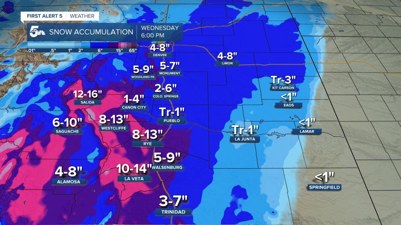
The mountains and higher elevations could be looking at 1-2 feet of snow, though melting may factor in. I except very little collection from Pueblo east into the Lower Arknasas River Valley. These areas may only see an inch or two of accumulation at most.

The other story will be the cold, with Freeze Warnings in effect overnight for a large portion of Southern Colorado.
COLORADO SPRINGS: Low: 27; High: 38. Heavy overnight snow will start to let up by Wednesday morning. A few flurries or light snow showers will be possible again by the afternoon, but not much additional accumulation is expected. Highs will only warm into the 30s and it will be breezy.
PUEBLO: Low: 30; High: 43. A wintry mess early in the day for Pueblo, with a mix of rain and snow. This will be followed by the chance for some light rain or snow showers during the day, along with unseasonably cold temperatures.
CANON CITY: Low: 30; High: 41. Snow will taper off by mid-morning across Fremont County as the main part of the storm pulls away. A few spotty rain and/or snow showers will be possible during the afternoon as the cold weather sticks around.
WOODLAND PARK: Low: 20; High: 32. We'll see periods of heavy snow through the overnight hours and into Wednesday morning. The rest of the day will be cloudy, with some leftover flurries or light snow showers.
TRI-LAKES: Low: 20s; High: 30s. Leave yourself some extra time to shovel your driveway and sidewalk Wednesday morning as more than 6" of snow will be possible during the overnight hours. The snow should shut down by mid morning, with only a few light flurries or snow showers by the afternoon.
PLAINS: Low: 30s; High: 30s/40s. Most of the far east Plains won't see much snow from this somewhat unusual early September storm. Farther west, there could be some light accumulations. Highs on Wednesday will be cold, with some occasional light rain or snow showers.
WALSENBURG/TRINIDAD: Low: 20s; High: 30s. Overnight snow will taper off by mid to later morning, with just a few flurries expected to linger into the afternoon hours. Snow totals will be highest near the Raton Mesa.
Extended Outlook:
Before the winter storm pulls away from Southern Colorado on Thursday, we might see some additional light rain showers or mountain snow showers. By Friday, the storm will be gone as sunshine returns to the region. This will set the stage for a gorgeous weekend of weather as highs will bounce back to the 60s, 70s and 80s.
