


Tonight's Forecast:
A weak cold front will bring the potential for 20-30 mph wind gusts to the Plains overnight tonight and into Sunday morning. A few mountain snow showers may also develop over the central mountains after midnight, with the potential for a few flurries or light snow showers over the Palmer Divide by the morning.
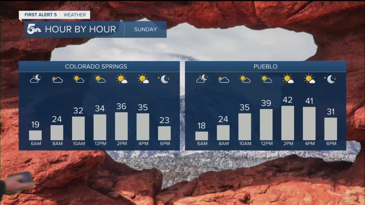
Colorado Springs forecast: Low: 19; High: 37. After a bright and mild Saturday, Sunday will be much cooler thanks to a weak disturbance moving into Southern Colorado from our north. A few light snow showers may form over the Palmer Divide, with a flurry or two also possible in town.
Pueblo forecast: Low: 18; High: 42. Even though we'll be cooler on Sunday, snow will continue to melt as highs warm above the freezing mark, topping out in the lower to middle 40s.
Canon City forecast: Low: 21; High: 38. Mostly cloudy skies early will give way to a bright, but cooler afternoon in Fremont County, with dry skies as we close out the weekend.
Woodland Park forecast: Low: 12; High: 28. The winter chill returns on Sunday courtesy of a weak disturbance that comes with the potential for a few morning snow showers in Teller County. Snow totals from 0-1".
Tri-Lakes forecast: Low: 10s; High: 20s/30s. A much cooler end to the weekend for northern El Paso County as a weak disturbance arrives, with a slight chance for snow early in the day. Any snow that does accumulate should stay under an inch.
Plains forecast: Low: 10s/20s; High: 40s. A weak storm system will bring us a cooler end to the weekend, but no snow is expected from this storm. Instead, northerly wind gusts to 30 mph will be possible throughout the day.
Walsenburg and Trinidad forecast: Low: 10s/20s; High: 20s/30s. A weak storm is expected to bring some light snow on Sunday to the Sangres, but the potential for snow is not as promising for the southern I-25 corridor.
Mountains forecast: High: 0s/10s; Low: 20s/30s. A weak disturbance may bring a few snow showers to the mountains on Sunday, with the best chance for a quick inch or two being up across the southern Sangres.
Extended outlook forecast:
With high pressure expanding from the West Coast into the Rocky Mountain states this week, we're looking at a fairly mild and benign weather pattern. A few disturbances will try to drop into the state at times next week, but nothing looks too promising for any widespread snow at this point. Stay tuned.
____
Watch KOAA News5 on your time, anytime with our free streaming app available for your Roku, FireTV, AppleTV and Android TV. Just search KOAA News5, download and start watching.
