


Tonight's Forecast:
The first in a series of storms to move into Southern Colorado will bring the potential for a few rain and snow showers through late this evening. A few spots in Teller County and near the Palmer Divide could see light accumulations of up to 1" of snow, with little to no impacts elsewhere.
Showers should come to an end before midnight, leaving us with decreasing clouds and below freezing temperatures by early Monday morning.
Colorado Springs forecast: Low: 27; High: 49; A fair amount of sunshine will return to the Pikes Peak Region for MLK Day, making for a really nice end to the holiday weekend.
Pueblo forecast: Low: 25; High: 55; Although blue skies will return to the Steel City on Monday, our forecast will be a little on the windy side at times, with gusts up to 35 mph.
Canon City forecast: Low: 29; High: 50; MLK Day is shaping up to be a breezy, but beautiful day for the Canon City area. Make sure to get outside and enjoy it before our next snow storm arrives late Tuesday.
Woodland Park forecast: Low: 18; High: 37; A calm, yet chilly MLK Day will give way to a potent mid-week storm, with the potential for 4-7" of snow from Tuesday afternoon through Wednesday afternoon.
Tri-Lakes forecast: Low: 20s; High: 40s; Sunshine and 40s on MLK Day will give way to a cooler and more unsettled mid-week forecast as the first big storm of the year arrives on Tuesday.
Plains forecast: Low: 20s/30s; High: 50s; A near picture perfect end to the holiday weekend for the Plains of Southern Colorado, with mostly sunny skies and 50s for daytime highs.
Walsenburg and Trinidad forecast: Low: 20s/30s; High: 40s/50s; Dry, but windy again on Monday for the southern I-25 corridor, with peak afternoon wind gusts topping 30-40 mph.
Mountains forecast: Low: 10s/20s; High: 20s/30s; A generally dry, but windy MLK Day for the mountains of Southern Colorado will be followed by our next round of snow that should move back into the high country by Tuesday morning.
Extended outlook forecast:
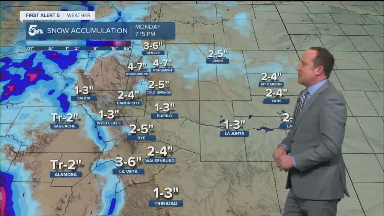
Last month it was the Polar Express, and this week, we'll get our first real taste this year of life aboard the Storm Express. Several rounds of snow can be expected, with the potential for a much more potent storm to hit Southern Colorado from Tuesday afternoon through Wednesday afternoon. With the exact track of the storm still being worked out, I do expect that these totals will change over the next day or two. That said, here's my current thinking for snowfall amounts.

Be advised that a storm of this size will bring disruptions to travel, possible road closures and possible school delays/closures. With the storm picking up Tuesday night, the Wednesday morning commute could be quite tricky.
The storm should clear out by Wednesday evening, with one dry day Thursday before the third storm of the week brings snow back to our forecast on Friday.
____
Curious about the First Alert 5 Weather Storm Impact Scale? Check out our cheatsheet explainer.
Watch KOAA News5 on your time, anytime with our free streaming app available for your Roku, FireTV, AppleTV and Android TV. Just search KOAA News5, download and start watching.
