

Today’s Forecast:
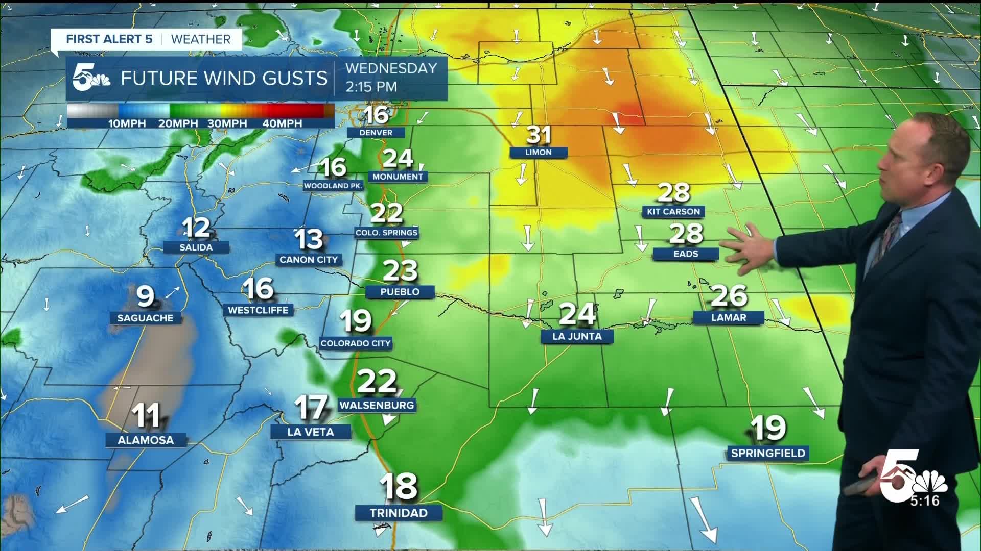
Beautiful weather so far this week will continue on Wednesday as dry skies are anticipated for the next 12-24 hours across Southern Colorado. An incoming cold front won't bring any rain to our forecast today, but it will bring some gusty winds to the Plains. Peak wind gusts this afternoon are expected to range between 15-30 mph, with the potential for stronger gusts north of I-70.
On top of the wind and warming highs on Wednesday, the NW flow will also help to transport some smoke and haze from big blazes burning in Canada down to Colorado. Don't be surprised if skies are a little bit hazy today and tomorrow.
Colorado Springs forecast: High: 84; Low: 53. In spite of news of an incoming cold front, highs on Wednesday will continue to warm, topping out in the middle 80s. The cold front will bring us a breezy to gusty afternoon, with north wind gusts of 15-30 mph in the Pikes Peak Region.
Pueblo forecast: High: 91; Low: 55. Wednesday will be bright, but hazy as some smoke filters in this afternoon from wildfires burning in Canada. Locally, an incoming cold front will bring 20-30 mph wind gusts to our forecast this afternoon.
Canon City forecast: High: 88; Low: 57. Skies will go from sunny this morning to partly cloudy this afternoon, but rain is not expected on Wednesday in eastern Fremont County. Northerly wind gusts this afternoon will be around 20 mph.
Woodland Park forecast: High: 75; Low: 43. We can expect dry skies and warming highs on Wednesday as daytime highs this afternoon climb into the middle 70. Winds will be elevated compared to Tuesday, with peak gusts around 15-25 mph this afternoon.
Tri-Lakes forecast: High: 70s/80s; Low: 40s/50s. Warming highs on Wednesday will be driven by a large region of high pressure to our west. At the same time, a strong low pressure system to the northeast will send a cold front into the state, and this will produce some gusty winds through this evening.
Plains forecast: High: 80s/90s; Low: 50s. On top of warming highs on Wednesday in the upper 80s and 90s, the wind will be the big story. Peak northerly gusts this afternoon will be up around 25-35 mph.
Walsenburg and Trinidad forecast: High: 80s; Low: 50s. Warm, with sunshine early that gives way to a partly cloudy and breezy afternoon. Peak gusts today will be around 20-25 mph.
Mountains forecast: High: 60s/70s; Low: 30s/40s. Outside of areas closer to the Continental Divide, we should see a drier day for the southeastern mountains compared to the past few afternoons. If we do see a shower today, it would be short-lived and shouldn't disrupt plans for too long.
Extended outlook forecast:
With the influence of high pressure to our west on Thursday and with weakening wind, we can expect some heat to go along with hazy sunshine. Highs will climb into the upper 80s tomorrow in Colorado Springs, which is well above the average high of 81 degrees. Highs in Pueblo and Canon City will climb all the way back into the 90s on Thursday.
A much stronger cold front will sweep across the state Thursday night. Behind the front, it will be much cooler on Friday, with our high in Colorado Springs only warming into the upper 60s. By Friday afternoon, scattered showers and thunderstorms will be possible. Highs will rebound into the 70s and 80s on the Plains this weekend, with a daily threat of thunderstorms each afternoon.
____
Curious about the First Alert 5 Weather Storm Impact Scale? Check out our cheatsheet explainer.
Watch KOAA News5 on your time, anytime with our free streaming app available for your Roku, FireTV, AppleTV and Android TV. Just search KOAA News5, download and start watching.
