

Today’s Forecast:
A weak cold front pushed south through Southern Colorado overnight. You'll see clearing skies this morning behind the front, and it will be cold. For any longer duration outdoor activities, you'll be best off waiting until after 9 AM. After that time, breezes will increase out of the northwest. This wind direction is downslope - meaning the air descends, compresses, and warms up. The wind also helps to mix up the air in the lower levels of the atmosphere. Combined this will warm temperatures up into the lower 40s by late morning.
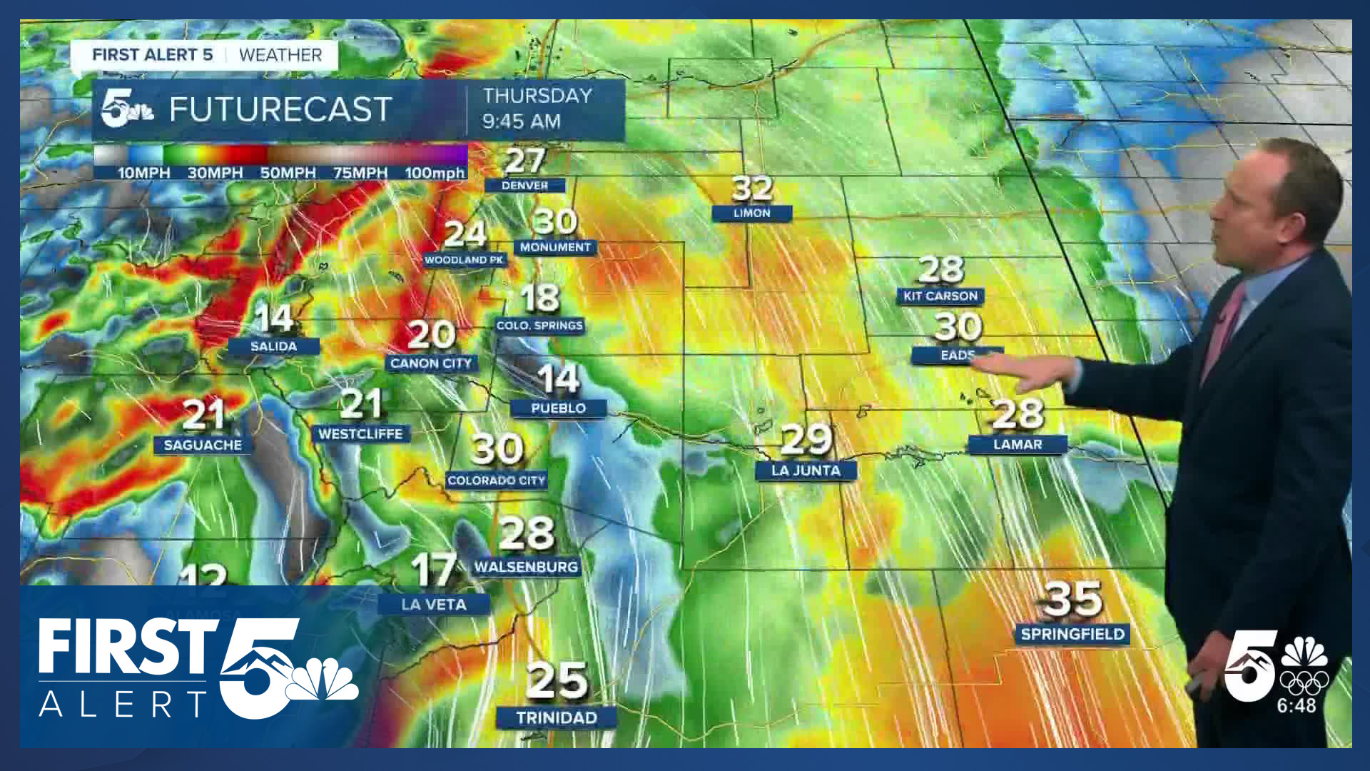
Ultimately it will be a mainly sunny day, and breezy. Wind gusts of 20-35 mph are expected across Southern Colorado from late morning through late afternoon. Highs will be near average.
Colorado Springs forecast: High: 44; Low: 19. Breezy and cooler weather on Thursday will come in the wake of yesterday's cold front. Highs this afternoon will be near average for this time of the year, with gusts to 30 mph possible in the Pikes Peak Region.
Pueblo forecast: High: 49; Low: 17. After warming into the lower 50s on Wednesday, our highs today will be modestly cooler in the upper 40s. Gusty NW flow across the region will bring the potential for 20-30 mph wind gusts throughout the day.
Canon City forecast: High: 49; Low: 23. Thursday will be a seasonable day, but breezy day, with NW wind gusts around 20-30 mph. Skies will be mostly sunny on Thursday, and mostly clear this evening.
Woodland Park forecast: High: 38; Low: 13. A dry and cool late January day can be expected across Teller County on Thursday. It will be breezy at times as well, with peak gusts to 30 mph.
Tri-Lakes forecast: High: 30s/40s; Low: 10s. Behind last night's cold front will come a breezy and cooler day. Highs in the Tri-Lakes are will arm into the upper 30s and lower 40s, with peak wind gusts this afternoon to 30 mph.
Plains forecast: High: 40s/50s; Low: 10s/20s. Sunshine and near average highs on Thursday will make for a gorgeous late January day on the eastern Plains. It will be pretty gusty today however, with peak gusts up to 35 mph.
Walsenburg and Trinidad forecast: High: 30s/40s; Low: 10s/20s. Modest cooling on Thursday will result in afternoon highs in the upper 30s and 40s. NW wind gust will approach 20-30 mph this afternoon before weakening this evening.
Mountains forecast: High: 20s/30s; Low: 0s/10s. Light snow showers in the central and northern mountains will dissipate by late this morning, leaving us with clearing skies and gusty NW winds. Peak afternoon wind gusts will be around 30-40 mph.
Extended outlook forecast:
It will be another chilly but seasonal day Friday as high pressure remains to the west. Skies will be clear in the morning and it won't be as breezy. Highs will be similar to Thursday - in the 40s for most of Southern Colorado. A backdoor cold front arrives on Friday. Backdoor fronts arrive from the east or northeast - and they're named that way because most weather in the mid-latitudes (including Colorado) moves west to east. This may result in flurries over the eastern Plains. It will lead to low clouds Friday night in the Pikes Peak Region.
While Saturday morning will be cold and cloudy, the cold air doesn't linger. By the afternoon we're back to the 50s as skies clear. Sunday and Monday remain quiet as upper level ridging shifts east and temperatures continue to warm. By Monday afternoon, a northern disturbance will push a cold front south into Colorado. This system may produce some light snow showers on Tuesday, but the main impact is cooler temperatures in the middle of next week.
____
Curious about the First Alert 5 Weather Storm Impact Scale? Check out our cheatsheet explainer.
Watch KOAA News5 on your time, anytime with our free streaming app available for your Roku, FireTV, AppleTV and Android TV. Just search KOAA News5, download and start watching.
