


Tonight's Forecast:
After near recording setting temperatures earlier this afternoon in the Springs and Pueblo, we'll be slow to cool down this evening across Southern Colorado. On top of that, we're watching a disturbance moving over eastern Arizona, which will bring the potential for a few isolated mountain showers and thunderstorms to the forecast. Most of the activity is likely to stay over the San Juan Mountains.
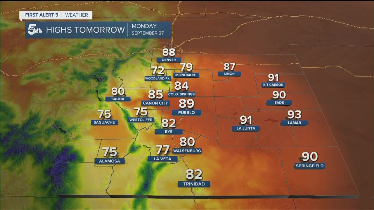
COLORADO SPRINGS: Low: 55; High: 84. Warm and breezy on Monday, with a very small chance of a thundershower in the Pikes Peak Region Monday night.
PUEBLO: Low: 52; High: 89. While it won't be as hot as today, highs on Monday will still be well above average for this time of the year. Much like the Pikes Peak Region, an isolated shower may develop by Monday evening.
CANON CITY: Low: 59; High: 85. Warm and breezy, with partly to mostly cloudy skies and a slight chance of rain by Monday evening.
WOODLAND PARK: Low: 47; High: 72. A nice start to the week for Teller County, with only an isolated shower possible Monday night and better chances for rain the rest of the week.
TRI-LAKES: Low: 40s/50s; High: 70s/80s. Warm and breezy on Monday, with a mix of sun and clouds giving way to a slight chance of an evening shower or thunderstorm.
PLAINS: Low: 50s; High: 80s/90s. Not as hot as the weekend, but still feeling like summer rather than fall across the Plains.
WALSENBURG/TRINIDAD: Low: 40s/50s; High: 70s/80s. Moisture and instability will be on the rise across the southern I-25 corridor and Raton Mesa on Monday, with an improved chance for scattered afternoon showers and thunderstorms to develop.
MOUNTAINS: Low: 30s/40s; High: 60s/70s. A touch cooler on Monday, with better chances for afternoon showers and thunderstorms to develop over the mountains and mountain valleys.
Extended Outlook:
We can expect another round of mountain showers and thunderstorms on Tuesday, along with the potential for some isolated thunderstorms for the I-25 corridor and Plains. Highs will be cooler Tuesday, with further cooling Wednesday into Thursday following the passage of a cold front. For now, Wednesday looks like our best chance for widespread rainfall. This will be followed by a cool and unsettled day on Thursday as highs only warm into the 50s and 60s.
Later this week, drier conditions are expected to return beginning Friday before possibly extending into the start of the weekend.
KOAA News5 on your time, streaming on your Roku, FireTV, AppleTV and AndroidTV.
News5 App | First Alert 5 Weather App | Youtube | Facebook | Instagram | Twitter
