


Today’s Forecast:
A beautiful fall day is ahead in southern Colorado - although, as usual, even our nice days still have some interesting weather going on. We'll start off the morning with some clouds out ahead of an incoming cold front. Those clouds will decrease through the day while winds increase. Overall you can expect a mainly sunny day.
The cold front will move through early this afternoon. Temperatures should fall about 10 degrees within the first hour following the front - it's potent - and wind gusts will increase noticeably as it passes.
Temperatures will warm up through the morning with the cold front arriving early in the afternoon. Highs will be in the low to mid 60s, within a few degrees of Friday's highs. Expect breezes from late morning through the late afternoon from the north, sustained at 15-20 mph, gusting to 30 mph.
Colorado Springs forecast: High: 64; Low: 30.
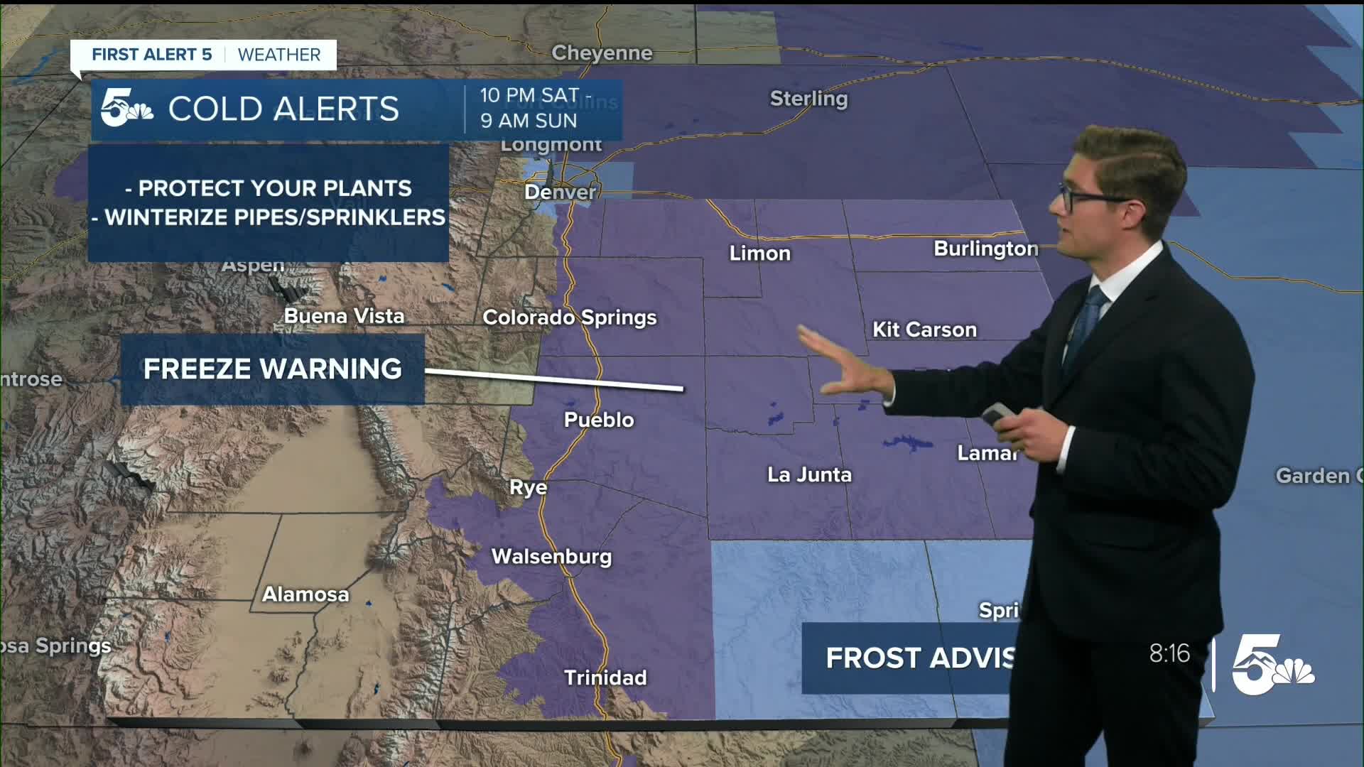
FREEZE WARNING in effect from 10:00 PM tonight - 9:00 AM SUN
After a few morning clouds, expect a sunny day in the Pikes Peak Region. It will become increasingly breezy through the day. This morning, winds at 10-15 mph, this afternoon 15-25 mph gusting to 30-35 mph from the north as the cold front passes the area.
Pueblo forecast: High: 71; Low: 31.
FREEZE WARNING in effect from 10:00 PM tonight - 9:00 AM SUN
After some high morning clouds...sunny and comfortable. Northwest winds at 10-20 mph, increasing through the day, and gusting to 35 mph this afternoon mainly after the cold front arrives. Expect a sharp temperature drop behind the front.
Canon City forecast: High: 70; Low: 35.
Sunny and breezy with northwest winds at 10-20 mph. A few gusts to 25 mph are possible, otherwise a very nice day.
Woodland Park forecast: High: 55; Low: 29.
Sunny and crisp with northwest winds at 15-25 mph, gusting to 30 mph at times this afternoon.
Tri-Lakes forecast: High: 60s; Low: 20s/30s.
FREEZE WARNING in effect from 10:00 PM tonight - 9:00 AM SUN
Sunny, mild, and gusty today with northwest winds at 10-15 mph this morning shifting north and increasing to 15-25 mph this afternoon, gusting to 35 mph after the front passes.
Plains forecast: High: 60s; Low: 30s.
FREEZE WARNING in effect from 10:00 PM tonight - 9:00 AM SUN
FROST ADVISORY in effect from 10:00 PM tonight - 9:00 AM SUN for Baca, E. Las Animas counties
Sunny and mild with northwest winds at 10-15 mph, shifting north at 15-25 mph gusting to 45 mph this afternoon.
Walsenburg and Trinidad forecast: High: 66/68; Low: 34/33.
FREEZE WARNING in effect from 10:00 PM tonight - 9:00 AM SUN
Sunny with northwest winds at 10-20 mph, shifting north in late afternoon and gusting to 35 mph.
Mountains forecast: High: 50s; Low: 20s/30s.
Windy and cool today with north winds at 15-25 mph, gusting to 35-50 mph with higher gusts at higher elevations.
Extended outlook forecast:
A Freeze Warning is in effect tonight from 10 PM - 9 AM for the southeastern plains outside of Baca and E. Las Animas counties. Protect or bring inside any sensitive plants, and ensure your pipes and sprinklers are winterized.
Downslope winds and sunshine on Sunday will lead to a temperature rebound back above average It will again be breezy in the afternoon with winds out of the west, less breezy than on Saturday.
Roller-coaster temperatures is the theme of the week - as a series of cold fronts moves through the area, separated by periods of sunshine and downslope warmth. On Monday, our next cold front arrives. It will be windy as well. It will be cooler Tuesday behind the front before we warm back above average again Wednesday to the 70s for most areas.
Yet another system approaches Thursday, this time bringing some potential showers.
____
Curious about the First Alert 5 Weather Storm Impact Scale? Check out our cheatsheet explainer.
Watch KOAA News5 on your time, anytime with our free streaming app available for your Roku, FireTV, AppleTV and Android TV. Just search KOAA News5, download and start watching.
