

Today’s Forecast:
Southern Colorado continues to thaw out from our arctic blast and winter weather systems, as highs return to average (mid-30s to upper-40s) for the first time since Tuesday.
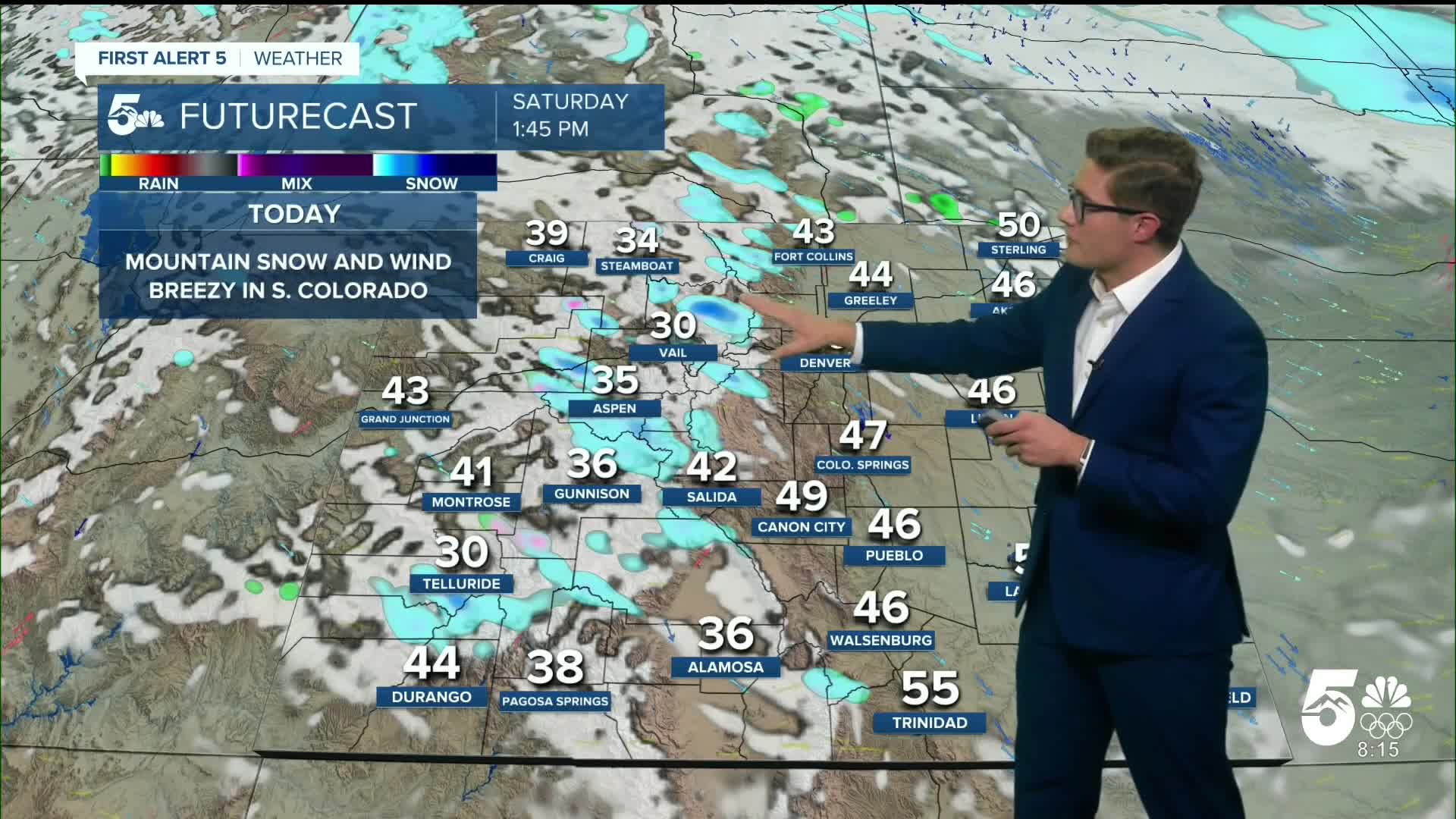
A powerful winter system is currently slamming the central, northern, and northern Front Range mountains - with widespread Winter Storm Warnings active through this afternoon. The Colorado Avalanche Information Center (CAIC) has also issued relatively widespread avalanche warnings for the first time this season. These do include major mountain passes along I-70. This is on top of the ongoing winter storm, which is producing blowing snow and low visibility. Across the southern mountains, it's been very windy with the same system producing multiple reports of 70+ mph wind gusts this morning on the lee side. In general: it's not a good morning to drive to the high country. It will become safer to travel this afternoon once the storm system begins to clear out, but remain prepared for icy roads and potential closures.
Across our area, it will become breezy later this morning and through much of the afternoon across the entire reading area, but while the gusts will be widespread, they won't be as strong as the mountain gusts - more in the range of 25-30 mph, and they'll quickly reduce heading into the mid afternoon.
Highs bump up by 5-10 degrees today compared to Friday, under partly cloudy to mostly sunny skies (with wave clouds filtering in and out). A weak cold front will brush through associated with the mountain system late this afternoon. Woodland Park may see a few snow showers as that energy pushes through.
Colorado Springs forecast: High: 46; Low: 20.
Breezy and mostly sunny, with the wind strongest west of I-25 through the late morning to early afternoon out of the northwest. Overall, winds will be sustained at 10-20 mph, gusting to 40 mph at times, with isolated stronger gusts early close to the mountains in favored areas.
Pueblo forecast: High: 47; Low: 18.
Mostly sunny with downslope "warmth" - technically today we're just heading back to average, but it'll feel a lot warmer than the arctic blast earlier this week! West winds at 10-20 mph, gusting to 40 mph, mainly before 4 PM.
Canon City forecast: High: 49; Low: 22.
Windy today! West winds at 15-30 mph, gusting to 55 mph into the early afternoon. Otherwise mostly sunny, with winds steadily reducing heading into the late afternoon and evening.
Woodland Park forecast: High: 39; Low: 12.
An isolated snow shower or two is possible as energy "spills over" from the main moisture center of the winter system impacting central and northern Colorado today. Otherwise, it'll be gusty, with northwest winds at 10-25 mph, gusting to 50+ mph, mainly before 3 PM. If you're in a particularly wind prone location, and you have not already done so, you may want to consider moving lightweight items inside temporarily (lawn chairs/furniture, trash cans). Mainly sunny.
Tri-Lakes forecast: High: 40s; Low: Teens.
Mostly sunny and gusty. Northwest winds at 10-20 mph, gusting to 40 mph.
Plains forecast: High: 50s; Low: Teens.
Sunny, and somewhat breezy - but much less so than areas further west. Northwest winds at 10-30 mph.
Walsenburg and Trinidad forecast: High: 46/55; Low: 22/23.
Very windy - with west winds sustained at 15-25 mph, gusting to 50-60 mph before 12PM, and to 30-40 mph through the mid-afternoon. Wind speeds continue to decrease heading into the evening.
Mountains forecast: High: 30s/40s; Low: Teens.
Very windy. Northwest winds at 15-35 mph, gusting to 50-65 mph, particularly before 12PM, then gusting to 30-45 mph after 12 PM. Mostly sunny.
Extended outlook forecast:
Conditions in the high country improve Saturday night and into Sunday morning.
It will be cooler Sunday in southern Colorado following this evening's weak cold front, with highs back in the upper 30s to low 40s.
We warm up early next week with highs above average - with the cities along the Front Range and the plains returning to the 50s.
The big picture weather pattern next week is northwest flow, which we're already in now. That results in moisture hitting the northern and central mountains, and often produces gusty wind here in southern Colorado. It's a classic La Nina set up. Given that the airflow remains in that orientation next week, we should see more of the same: more mountain snow (although nothing to suggest any one system is as "big" as the current one hitting them), and breezes locally.
We're likely to get a backdoor cold front mid-week in southern Colorado, which will lead to slightly more unsettled conditions in the second half of the week.
____
Curious about the First Alert 5 Weather Storm Impact Scale? Check out our cheatsheet explainer.
Watch KOAA News5 on your time, anytime with our free streaming app available for your Roku, FireTV, AppleTV and Android TV. Just search KOAA News5, download and start watching.
