


Tonight's Forecast:
After a sizzling end to the holiday weekend, temperatures will be slow to cool tonight across Southern Colorado. Under hazy skies, overnight lows will eventually cool down to the 40s in the mountains and mountain valleys, with 50s and 60s for the Plains.
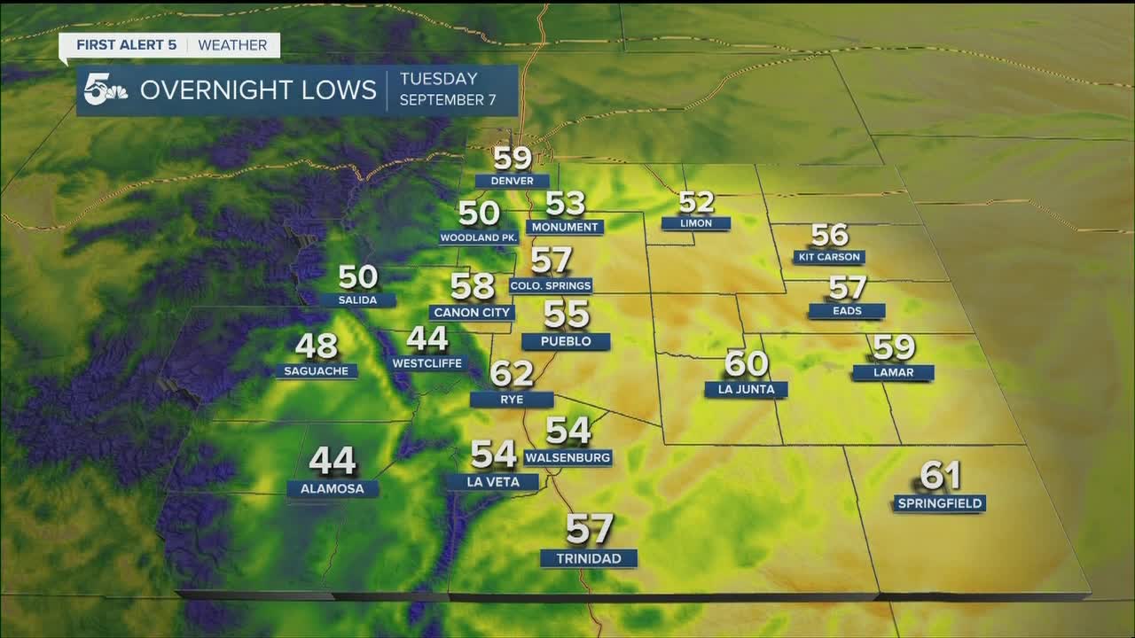
COLORADO SPRINGS: Low: 57; High: 87. An early morning cool front will offer up a modest amount of cooling on Tuesday, along with thicker smoke and gusty winds.
PUEBLO: Low: 55; High: 93. Cooler than Labor Day, but still a hot and hazy day on Tuesday as we return to work and school after the long holiday weekend.
CANON CITY: Low: 58; High: 90. Hazy sunshine and a bit on the breezy side for Canon City on Tuesday. Highs will be slightly cooler, but still above average for this time of the year.
WOODLAND PARK: Low: 50; High: 78. We should see a slightly cooler and breezy day across Teller County on Tuesday, along with a thicker layer of smoke.
TRI-LAKES: Low: 50s; High: 80s. Haze and smoke will be on the rise on Tuesday after a cool front arrives early in the day. Behind the front our weather will turn windy and slightly cooler.
PLAINS: Low: 50s/60s; High: 80s/90s. Windy and slightly cooler for the Plains on Tuesday behind an early morning cool front. No rain is expected from the front, but instead, thicker smoke and haze will filter into the region.
WALSENBURG/TRINIDAD: Low: 50s/60s; High: 80s. Dry with hazy skies and slightly cooler highs on Tuesday. A passing morning cold front will also bring gusty winds to the forecast for a few hours.
MOUNTAINS: Low: 40s/50s; High: 70s. Hazy skies and breezy easterly winds will impact the mountains of Southern Colorado on Tuesday, with rain or snow not expected in the forecast.
Extended Outlook:
Dry and hazy skies will continue on Wednesday, with temperatures on par with Tuesday's highs. A late week warm-up will come courtesy of a building ridge of high pressure that will bring the potential for record setting heat to the forecast on Thursday and Friday. The heat is likely to continue into Saturday, but it's not a slam dunk yet as some of the longer range models suggest a weak disturbance moving into the state that could bring the mountains some rain showers and the rest of us some relief from this heat.
KOAA News5 on your time, streaming on your Roku, FireTV, AppleTV and AndroidTV.
News5 App | First Alert 5 Weather App | Youtube | Facebook | Instagram | Twitter
