

Today’s Forecast:
A well-advertised plume of sub-tropical moisture is moving into Colorado today. This moisture will upslope into the mountains, producing snow throughout the day. This snow will be heavy at times. Various winter alerts are in place across the mountain zones - some areas are likely to pick up over a foot of snow.
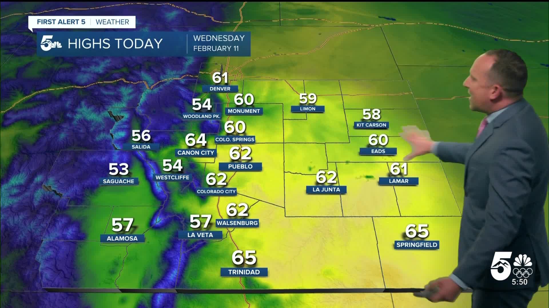
Across Southern Colorado, we're on the dry downslope side of this system today, with wind gusts of 20-25 mph this afternoon in the Pikes Peak Region. Highs will warm to the lower 60s with increasing PM cloud cover.
Colorado Springs forecast: High: 60; Low: 34. After yesterday's high of 45 degrees, today's highs will rebound into the upper 50s and lower 60s. Southwesterly winds will be sustained at 10-15 mph this afternoon, with 20-25 mph gusts possible.
Pueblo forecast: High: 62; Low: 30. Monday was our warmest day of February month, and Tuesday's high of 51 was our coolest. Temperatures will rebound into the lower 60s today, with breezy southwest winds during the afternoon.
Canon City forecast: High: 64; Low: 37. Yesterday's short-lived cool down will be replaced with another unseasonably warm, dry and breezy day. Our high today will be around 10-15 degrees above average, warming into the mid 60s.
Woodland Park forecast: High: 54; Low: 28. After yesterday's cool down, highs will return to the middle 50s today. It will be breezy to gusty on Wednesday as well, with afternoon gusts to 30 mph.
Tri-Lakes forecast: High: 50s/60s; Low: 20s/30s. Breezy, mild and beautiful on Wednesday, with moderate downslope breezes bringing another boost to our daytime highs.
Plains forecast: High: 50s/60s; Low: 30s/40s. Dry skies will persist for at least the next 12-24 hours, with temperature warming today under the influence of high pressure to our east. E/SE winds will be sustained at around 10-15 mph.
Walsenburg and Trinidad forecast: High: 60s; Low: 30s/40s. Downsloping winds will bring a nice boost to our highs today of around 10-15 degrees from yesterday. Above average temperatures in the 60s will be driven by W/SW wind gusts this afternoon to 35 mph.
Mountains forecast: High: 40s; Low: 20s. The southeastern mountains will be dry and gusty today, with W/SW wind gusts up to 45 mph. Most of the snow today will not impact the Wets or Sangres, but tonight, a few light snow showers will be possible.
Extended outlook forecast:
Thursday will begin mild as light downslope flow continues along with some mid-level cloud cover. Upper level energy continues to stream into the state ahead of the primary upper level low which will still be well west of Colorado. The first part of Thursday will be fairly mild and nice with highs warming to the 50s and 60s on the Plains. In the afternoon, airflow turns upslope. Light showers are possible in Woodland Park, which would be a mix to snow. A rumble of thunder is possible as there is a small amount of atmospheric instability. Periodic snow showers continue in the mountains, with a bit more of a convective pattern.
A cold front will swing south in the evening. This leads to a slight chance for evening showers across the Pikes Peak Region. Due to mild temperatures, these are likely to be rain, particularly below 6,500 feet. This moisture will depart by early Friday.
Round two of this storm complex will arrive Friday afternoon. This first leads to another round of mountain snow in the morning, with some rain in the San Luis Valley. Then, there is a chance of rain and snow showers on Friday night across the Pikes Peak Region and Southern Colorado as an upper level trough digs through the southeast corner of the state. The snow level looks fairly high - in the 6,500 to 7,000 foot range. As a result, places like the Palmer Divide and Woodland Park are likely to see snow, while downtown Colorado Springs is more likely to see rain or a slushy wintry mix. As temperatures cool, a brief period of snow is possible overnight into early Saturday morning.
There are still some uncertainties in exactly how fast this upper level system moves east, so Saturday morning may still have some cloud cover. Either way, by the afternoon skies are clearing.
By Sunday, we're tracking the next incoming system. For now, it looks to bring a significant wind Monday and Tuesday.
____
Curious about the First Alert 5 Weather Storm Impact Scale? Check out our cheatsheet explainer.
Watch KOAA News5 on your time, anytime with our free streaming app available for your Roku, FireTV, AppleTV and Android TV. Just search KOAA News5, download and start watching.
