

Today’s Forecast:
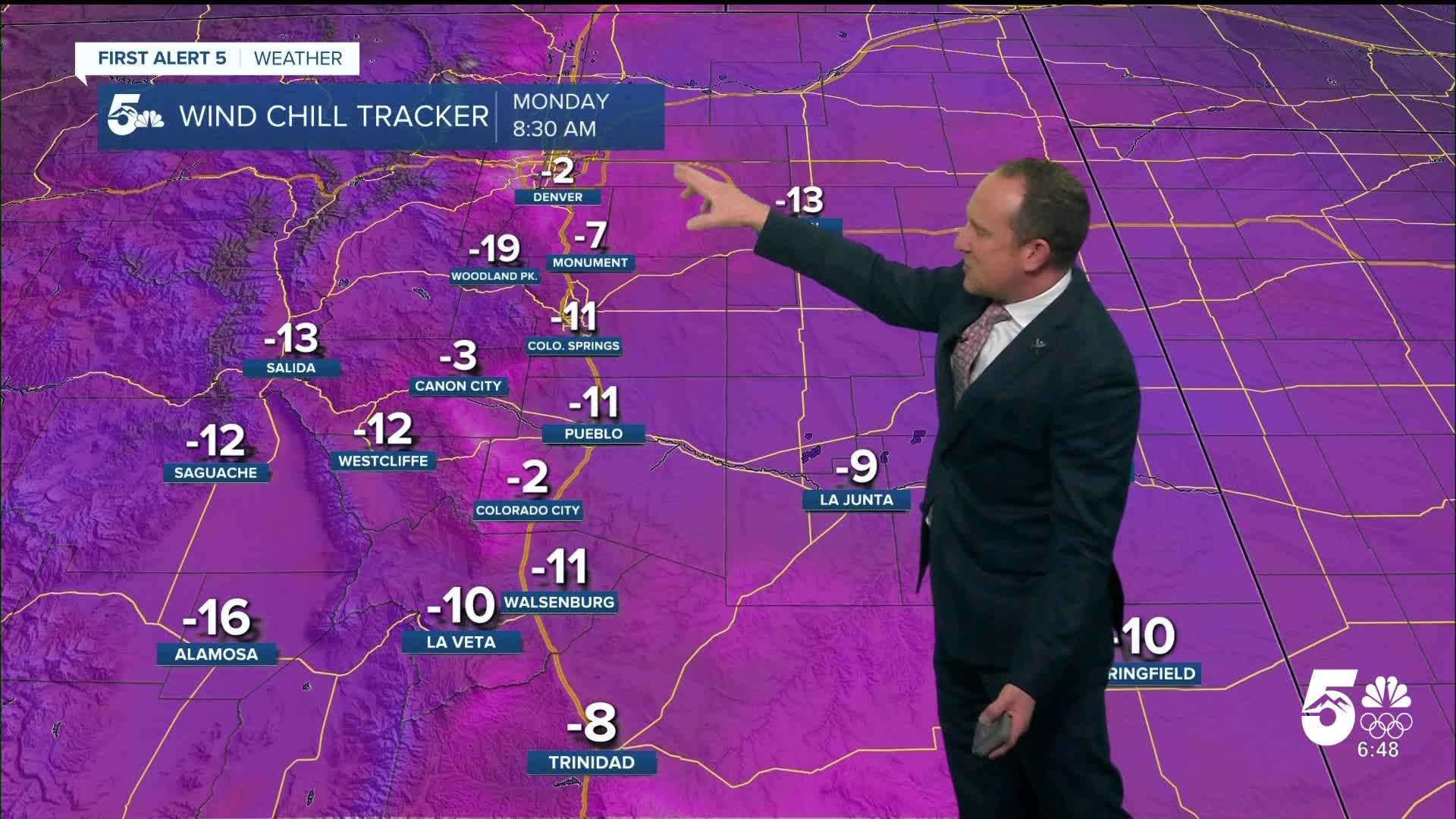
The worst of this past weekend's Arctic blast is happening right now. Morning temperatures have been below zero for Colorado Springs, Pueblo and the eastern Plains. Wind chill temperatures have been as cold as -30 to -35°F in Springfield and Limon, and as low as -15°F in the Pikes Peak Region. Cold Weather Advisories will remain in effect until 8 am. Frostbite on exposed skin will be possible in as little as 15 to 30 minutes, so if you have to be outside this morning, you need to be covered up and layered up.

As we approach the lunch hour, temperatures are expected to warm above freezing for the first time since last Thursday. Highs today will top out in the 30s and 40s under sunny skies. Winds will be westerly this afternoon, sustained between 10-20 mph.
Colorado Springs forecast: High: 38; Low: 16. A COLD WEATHER ADVISORY will remain in effect until 8 am. As the Arctic influence eases on Monday, high temperatures will warm to above freezing for the first time since Thursday afternoon.
Pueblo forecast: High: 40; Low: 12. We'll start out under a COLD WEATHER ADVISORY in Pueblo County. This will remain in effect until 8 am and although temperatures will be slow to warm, highs this afternoon will rise above freezing.
Canon City forecast: High: 43; Low: 18. We're starting out cold this morning in eastern Fremont County, but have not been included in today's cold weather alerts. This afternoon will be bright and sunny, with highs in the lower 40s.
Woodland Park forecast: High: 34; Low: 12. As the cold air clears out on Monday, highs will warm above freezing this afternoon. Snowmelt sunshine today will give way to a partly to mostly cloudy day on Tuesday.
Tri-Lakes forecast: High: 30s; Low: 10s. Monday's temperatures will warm from the single digits and teens into the 30s this afternoon, with sunshine expected throughout the day and breezy westerly wind gusts to 25 mph.
Plains forecast: High: 30s/40s; Low: 0s/10s. A COLD WEATHER ADVISORY will remain in effect until 8 am on the Plains, with some areas seeing wind chill temperatures as cold as -25 to -35°F this morning. Temperatures this afternoon will be much warmer than this past weekend, topping out in the 30s and 40s.
Walsenburg and Trinidad forecast: High: 30s/40s; Low: 10s/20s. A COLD WEATHER ADVISORY will remain in effect until 8 am. By the afternoon, breezy westerly wind gusts around 25-35 mph will help to warm temperatures into the 30s and 40s.
Mountains forecast: High: 20s/30s; Low: 0s/10s. As the snow and Arctic airmass pulls away from the state early this week, our weather will turn bright and gusty in the mountains on Monday, with peak gusts to 40 mph.
Extended outlook forecast:
The week ahead will feature near to slightly above average highs. Temperatures will rebound into the middle to upper 40s on Tuesday, and lower to middle 50s on Wednesday.
A weak disturbance will bring a chance for snow to the mountains late this week, with breezy and cooler conditions for the Plains and Pikes Peak Region. Highs will drop back down to the 40s on Thursday and Friday. It's too soon to tell if this storm will bring any snow to the Plains, but we'll watch it closely during the week and continue to keep you posted.
Curious about the First Alert 5 Weather Storm Impact Scale? Check out our cheatsheet explainer.
Watch KOAA News5 on your time, anytime with our free streaming app available for your Roku, FireTV, AppleTV and Android TV. Just search KOAA News5, download and start watching.
