

Today’s Forecast:
It will be very cold today in Southern Colorado and you should plan to cover any exposed skin. Light flurries are falling this morning across the Palmer Divide and other parts of the Pikes Peak Region. Upslope flow will keep low clouds, freezing fog, and flurries around this morning. Snow impacts will be low - but cold impacts will be high.
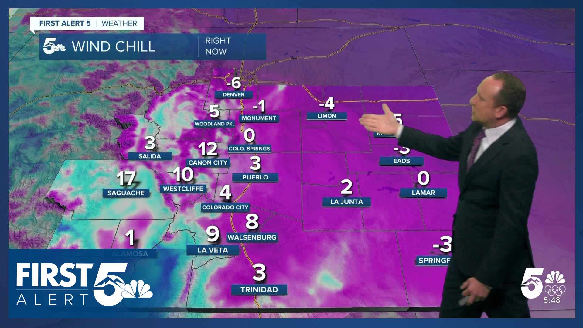
Frostbite times drop below 30 minutes when the windchill is -18 degrees or colder. While the windchills won't be quite that low today, they will be below or near 0 in many places. Superficial frostbite, called frostnip, can occur relatively quickly with negative wind chills. This is why it's so important today to keep exposed skin covered.

Temperatures won't climb much today, in fact, we've very likely already reached our highs for the day early this morning. Temperatures will remain consistent or even fall though today due to the upslope flow behind our front bringing more cold air into the region. Wind speeds will also increase over the next several hours. Combined, feels like temperatures will fall through the day. This means frostbite risk will increase this afternoon and evening.
We'll see some additional snow showers develop late tonight.
Colorado Springs forecast: High: 17; Low: 1. With the Arctic air settling into the Pikes Peak Region this morning, high temperatures in many areas were likely reached just after midnight. Lower 10s can be expected for the rest of the day, with cloudy skies, and areas of fog and flurries. SE wind gusts of 20-30 mph will keep wind chill temperatures in the single digits.
Pueblo forecast: High: 18; Low: 1. After warming into the lower 50s on Thursday, today's forecast will be much, much colder. Friday's temperatures will only warm into the teens. Skies will be cloudy and it will be windy, with wind chill temps in the single digits.
Canon City forecast: High: 21; Low: 3. Our well advertised pattern change is here, with the cold air settling into the state on Friday. Temperatures today will mostly hover in the teens, with overcast skies and the chance for a few flurries or light snow showers.
Woodland Park forecast: High: 25; Low: 4. With today's shallow layer of cold air in place, temperatures will actually be warmer in Woodland Park and Teller County than they will be today in Colorado Springs and Pueblo. Areas of light snow will be possible on Friday, with accumulations through this evening expected to stay under 1".
Tri-Lakes forecast: High: 10s; Low: 0s. Cold, cold, and more cold can be expected through the weekend. Temperatures will hover in the teens today in northern El Paso County, with areas of fog and flurries this morning. Chances for snow will increase later tonight.
Plains forecast: High: 10s; Low: -0s/0s. Windy and cold, with today marking the start of our well advertised Arctic blast. Driven by 20-30 mph wind gusts, wind chill temperatures today will hover in the single digits, even below zero in some areas. Light snow will be possible at times as well.
Walsenburg and Trinidad forecast: High: 10s/20s; Low: -0s/0s. With the cold air's arrival in our forecast on Friday, you can expect highs this afternoon to be as much as 20-30 degrees colder than yesterday. SE winds will be blustery and even though we have a chance for snow today, accumulations are not likely until this evening or on Saturday.
Mountains forecast: High: 40s; Low: 20s. From the Sangres to the Wet Mountains, a Winter Weather Advisory will remain in effect from 11 am until 5 am Sunday. Accumulations of 4-10" will be possible. For the Wolf Creek Pass area, a Winter Storm Warning will remain in effect from 11 am Friday until 5 am Sunday. Accumulations of 10-20" can be expected in the eastern San Juans.
Extended outlook forecast:
The cold air sticks around through the weekend - it won't depart until Monday afternoon. Tonight, wind chills will drop to -10 to -25 across the eastern Plains, where Cold Weather Advisories have been issued. In the Pikes Peak Region, we fall to the low single digits for lows with well below zero "feels like" temperatures. Highs Saturday will be as cold, or colder, than today as a secondary Arctic cold front moves in overnight.

Accumulating snow will fall Saturday into Saturday night. Snow totals in the Pikes Peak Region will range from 1-3" with isolated 4" totals possible. Again, wind chills remain near zero to negative. Otherwise expect continued cloudy skies and cold temperatures.

Early Sunday morning, we get a quick break in the action before some additional snow showers return Sunday afternoon and evening. Again, the snow impacts with the system are relatively low in the Pikes Peak Region - the cold is the biggest impact.
If you plan to travel to the mountains, this is where we're expecting to see the bulk of the snow with this system. Winter Weather Advisories are in place from today through Sunday for most mountain zones. A Winter Storm Warning is in place for Wolf Creek Pass. Expect difficult mountain travel.
Sunday remains cold with highs only reaching the 20s before we begin warming up on Monday. Seasonal temperatures will return Tuesday and Wednesday in the middle 40s to lower 50s.
____
Curious about the First Alert 5 Weather Storm Impact Scale? Check out our cheatsheet explainer.
Watch KOAA News5 on your time, anytime with our free streaming app available for your Roku, FireTV, AppleTV and Android TV. Just search KOAA News5, download and start watching.
