

Today’s Forecast:
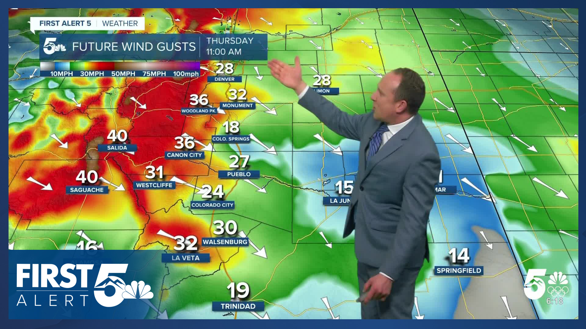
Fire threats continue Thursday in Southern Colorado. Areas near the mountains this morning are warmer than areas farther away - due to continued downslope breezes. Airflow is northwesterly in the upper levels of the atmosphere. These winds will mix down later this morning, with winds from late morning to mid-afternoon sustained at 15-25 mph, gusting to 35 mph in Colorado Springs. Higher gusts will occur today near the mountains. Humidity will drop to the 10-15% range, with Red Flag Warnings in place from 11 AM - 6 PM.
Highs today will be cooler - in the 60s and lower 70s on the Plains.
Colorado Springs forecast: High: 63; Low: 31. After record breaking heat earlier this week, today's cool down will take us down to the lower 60s. For perspective, that's still more than 12 degrees above our average high of 49. Fire danger will remain elevated on Thursday, with peak gusts to 35 mph.
Pueblo forecast: High: 68; Low: 27. After spending the past two days in the 70s and 80s, our cooler high of 68 degrees this afternoon will still soar well above the average high of 54. Gusty wind and low relative humidity will continue to plague the area, with a Red Flag Warning in effect from 11 am to 6 pm.
Canon City forecast: High: 68; Low: 35. Our warm, dry and windy spell continues on Thursday, with very little change to the forecast through at least the first half of the weekend. Highs today will warm into the upper 60s.
Woodland Park forecast: High: 53; Low: 28. If you're looking for a cool down, today would technically count as highs will drop a few degrees from what we saw on Wednesday. That said, our highs will remain more than 10 degrees above average on Thursday, and it will be gusty again this afternoon.
Tri-Lakes forecast: High: 50s/60s; Low: 20s/30s. Wind and high fire danger will remain a dangerous duo in northern El Paso County on Thursday. Peak gusts this afternoon could top 35 mph.
Plains forecast: High: 60s/70s; Low: 20s/30s. Due to higher levels of moisture on the High Plains today, Red Flag Warnings will largely remain absent from our forecast, with the highest fire danger expected to occur this afternoon near the higher terrain and I-25 corridor. The wind will also be weaker than the past few days, sustained from the NW at 10-15 mph.
Walsenburg and Trinidad forecast: High: 60s/70s; Low: 30s. The southern I-25 corridor will be back under a Red Flag Warning on Thursday, and it'll be our third day in a row with high fire danger. The usual wind prone spots could see gusts today to 45 mph.
Mountains forecast: High: 40s/50s; Low: 20s/30s. While snowflakes continue to fall this morning in the central and northern mountains. the southeastern mountains will be dry and windy on Thursday. Peak gusts in the mountain zones today will be around 40-50 mph.
Extended outlook forecast:
We warm up Friday back to the middle 60s and 70s on the Plains, with Fire Weather Watches in place for parts of Southern Colorado. Winds will not be as gusty as today, but with dry air and dry fuels, and potentially some 25 mph wind gusts, fire danger will still be elevated.
Saturday is fairly similar, but with increasing clouds through the day. There remains the potential for additional fire weather alerts.
Changes begin to take shape Sunday as a backdoor cold front arrives from the east, while Pacific moisture streams in from the northwest. The cold front will allow a bit of Gulf moisture to move into the Plains in the low atmosphere, with the Pacific moisture also streaming into Colorado in the upper levels. This will produce some mountain snow, particularly in the northern mountains. There is also a chance for an isolated shower in the Pikes Peak Region during the afternoon or evening. This low-impact and short-duration rain potential would nonetheless offer a welcome change to our current pattern. Highs Sunday will be cooler due to the front, additional clouds, and additional moisture - climbing to around 60 degrees in Colorado Springs.
The pattern remains cooler early next week as we drop to the 40s and 50s, with cooler upslope flow replacing this week's dry, downslope wind.
By Tuesday, increasing moisture and lift will lead to more widespread shower chances as a Pacific system pivots east and lift increases across Southern Colorado. That system will bring the potential for additional showers through Wednesday.
____
Curious about the First Alert 5 Weather Storm Impact Scale? Check out our cheatsheet explainer.
Watch KOAA News5 on your time, anytime with our free streaming app available for your Roku, FireTV, AppleTV and Android TV. Just search KOAA News5, download and start watching.
