

It was a record breaking day of heat in southern Colorado once again. For the second day in a row, Pueblo breaks the daily record high, at 103°. The previous record was 102° set in 1987. Colorado Springs tied the record of 93°, previously felt in 2003 and 1987.
Tonight’s Forecast: Any lingering spotty showers in the mountains or Plains will end shortly after sunset. This evening will be mild, still in the 70s for many by 10 pm. Overnight temperatures drop to the 50s and 60s. A cold front arrives late Wednesday morning which takes temperatures back at least 10 degrees from today. This front also reintroduces some moisture and thus rain potential. Watch for thunderstorms to develop in the mountains and along the front range by early afternoon, then move east into the Plains in the evening. There is a marginal (level 1 out of 5) risk of severe weather tomorrow. This means an isolated severe storm is possible within scattered general thunderstorms.
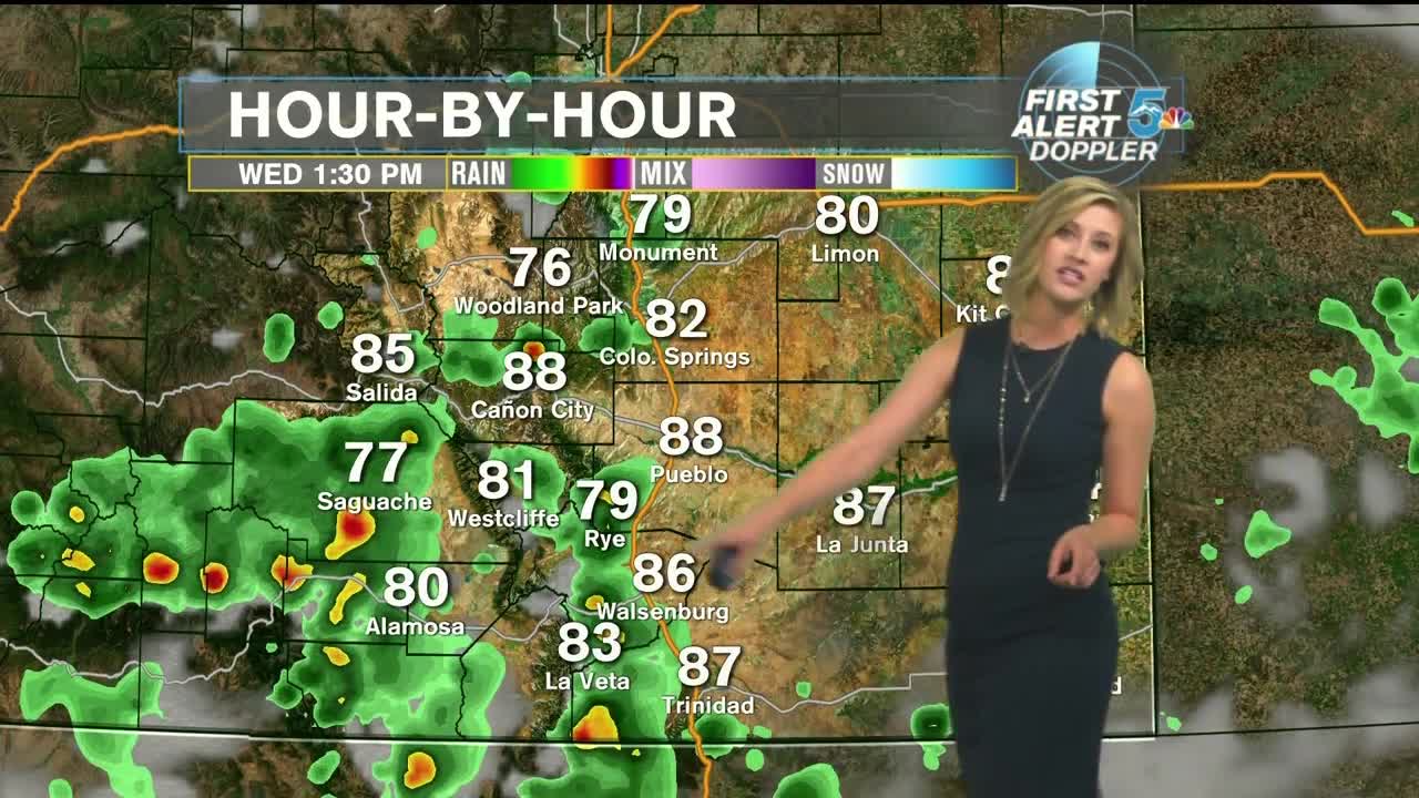
COLORADO SPRINGS: Low: 60, High: 84. Back to seasonable temperatures tomorrow in the 80s. The sky will be partly to mostly cloudy. Thunderstorms are likely after 1 pm and until the early evening.
PUEBLO: Low: 64, High: 89. Still warm tomorrow, but not in the triple digits! Expect morning sun followed by afternoon clouds and scattered thunderstorms.
CANON CITY: Low: 66, High: 89. The cold front will have a larger impact east of the mountains, but Canon City will still feel the effects, dropping to the upper 80s. Scattered showers and thunderstorms are likely in the early afternoon to late afternoon.
WOODLAND PARK: Low: 54, High: 76. Comfortable tomorrow, back to the mid 70s. Afternoon clouds and rain showers are likely, and thunderstorms should remain non-severe.
TRI-LAKES: Low: 50s, High: 70s. Did someone say 70s? Yes 70s for the Tri-lakes tomorrow thanks to our front! It arrives in the morning and limits highs to the upper 70s. Afternoon and evening thunderstorms are likely.
PLAINS: Low: 60s, High: 90s. Despite the cold front, there will be plenty of sunshine and later impacts from rain, which keeps the Plains warm. Low 90s will feel more comfortable at least. Watch for strong thunderstorms in the evening, traveling east through the night.
WALSENBURG/TRINIDAD: Low: 60s, High: 80s. Tomorrow the cold front arrives early afternoon and keeps highs to the low to mid 80s in Walsenburg and Trinidad. Late afternoon thunderstorms are likely.
Extended Outlook: A few more thunderstorms are likely Thursday afternoon, still with the cooler air. But then the heat returns Friday and continues to increase through the weekend. Sunday may be another record high temperature day in southern Colorado.