

Tonight’s Forecast:
Southeast winds will be light overnight, up to 10 mph. Temperatures will be mild, to the 50s and 60s. An isolated thunderstorm is possible tonight, but more so for the mountains. The sky will be clear waking up on Thursday, with a few afternoon clouds building in. Tomorrow the heat will build again, with a summer ridge of high pressure taking over.
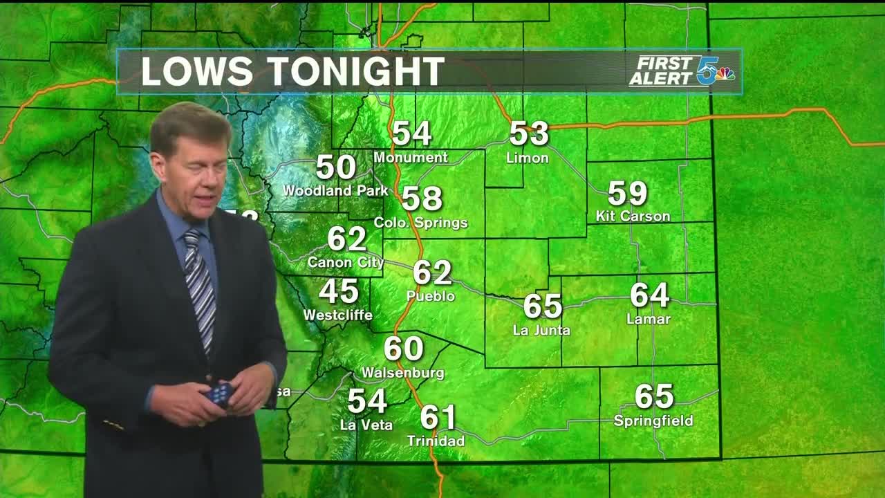
COLORADO SPRINGS: Low - 58; High - 89. Very warm tomorrow with mostly sunny to partly cloudy conditions. Heat builds back in tomorrow, with high temperatures just shy of 90 for the Springs. Rain activity should stay mostly in the mountains, with just an isolated chance of rain in the evening in El Paso county.
PUEBLO: Low - 62; High - 97. Hot weather returns tomorrow, reaching the upper 90s. The sky will stay mostly sunny all day, with a few afternoon clouds. The trend is dry tomorrow for Pueblo, with rain showers liekly staying west in the mountains.
CANON CITY: Low - 62; High - 94. Tomorrow will be a hot one, to the mid 90s in Canon City. There is a slight chance for an afternoon thunderstorm. The sky will be mostly sunny with a few clouds in the afternoon.
WOODLAND PARK: Low - 50; High - 82. Very warm tomorrow, with highs in the low 80s! An afternoon thunderstorm is possible, which will hopefully cool us down for the evening in Woodland Park.
TRI-LAKES: Low - 50s; High - 80s. Starting in the mid 50s, Thursday will warm up to the mid 80s in the afternoon. The sky will be sunny with a few afternoon clouds. An isolated thunderstorm is possible in the afternoon, with minimal impacts.
PLAINS: Low - 60s; High - 90s. Hot and dry is the trend tomorrow in the Plains. The morning will be mild in the 60s, then rising to the mid to upper 90s during the day. Slim chance of seeing clouds and rain tomorrow.
WALSENBURG/TRINIDAD: Low - 50s/60s; High - 80s/90s. A warm afternoon is in the forecast Thursday, to the upper 80s in Walsenburg and low 90s for Trinidad. The overall trend is sunny and dry. A few mountain showers are possible, less likely in east in lower terrain.
Extended Outlook:
Staying warm through the end of the week into the weekend, with rain chances on the increase. Temperatures will be about average on Friday, with a chance of isolated thunderstorms in the afternoon. Evening thunderstorms are looking likely for southern Colorado from Saturday until Tuesday. These will generally be slow moving, leading to localized flooding possible.
