

Today’s Forecast:
A warm ridge of high pressure to our west will win out the battle today over a weak area of low pressure over Arizona. The ridge will boost temperatures today by as much as 10-15 degrees from yesterday, with highs into the 60s on the Plains.
Light winds and mostly sunny skies during the day will give way to increasing clouds this evening and increasing wind over and near the higher terrain. Spillover wind into the I-25 corridor will keep temperatures mild heading into Tuesday morning.
Colorado Springs forecast: High: 64; Low: 33. After another brief dip down the 50s on Sunday, highs this afternoon will rebound back into the mid 60s, which is around 20 degrees above average for this time the year.
Pueblo forecast: High: 65; Low: 26. This past weekend brought a mixed bag of weather to Pueblo, and after record heat Saturday and a cool down to 50s on Sunday, highs will rebound into the middle 60s this afternoon.
Canon City forecast: High: 65; Low: 38. I hate to sound like a broken record, but once again, we'll see warm and dry conditions this afternoon. With light westerly breezes on Monday, it'll be a great day to get outside and take advantage of the dry skies.
Woodland Park forecast: High: 57; Low: 29. With temperatures rising into the upper 50s this afternoon, it'll feel more like mid-October than mid-December. Snow is not expected in Teller County for the next 12-24 hours.
Tri-Lakes forecast: High: 50s/60s; Low: 30s. If you're missing typical December weather, then keep up those snow dances. Today's forecast will be dry and mild, with light and variable winds.
Plains forecast: High: 60s; Low: 20s/30s. Light wind, dry skies and mild highs will make for a gorgeous Monday on the Plains, with highs today around 15-20 degrees above average.
Walsenburg and Trinidad forecast: High: 60s; Low: 30s. Mostly sunny to partly cloudy on Monday, and breezy near the foothills and across wind prone areas in Huerfano County. Peak gusts today will be around 20-30 mph.
Mountains forecast: High: 40s/50s; Low: 20s. Our weather in the high country will be dry and mild on Monday, with increasing wind expected tonight as a weak disturbance moves from Arizona into New Mexico.
Extended outlook forecast:
Tuesday will be a little breezier than today, especially near the mountains. Temperatures will warm back into the 60s on the Plains, which is about 20 degrees above average for this time of the year.
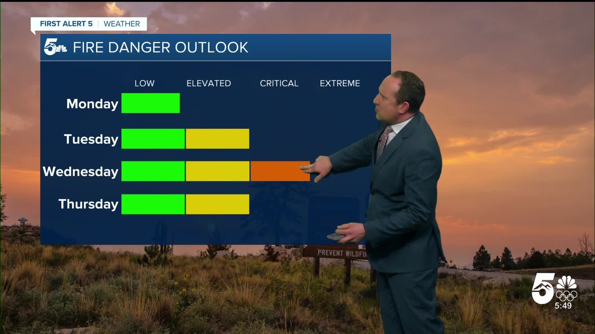
A strong storm crossing the northern Rockies will bring snow to the mountains on Wednesday and strong wind to the Plains. In the Pikes Peak Region, gusts of 40-50 mph will be possible by Wednesday afternoon. High fire danger will be a concern with the downslope wind dropping humidity levels down to the teens.
A Wednesday night cold front will shift the wind out of the north, with strong gusts continuing into Thursday morning. While the front looks to lack moisture, we can't rule out a few snow showers in the Pikes Peak Region, mainly focused up in Teller County.
After a Thursday cool down, highs will return to the 60s and lower 70s on the Plains on both Friday and Saturday.
____
Curious about the First Alert 5 Weather Storm Impact Scale? Check out our cheatsheet explainer.
Watch KOAA News5 on your time, anytime with our free streaming app available for your Roku, FireTV, AppleTV and Android TV. Just search KOAA News5, download and start watching.
