


Tonight's Forecast: Freezing drizzle early in the day has given way to snow across most of Southern Colorado this evening. With the snow falling on a thin layer of ice, roads will be slick and icy over the next 12 to 24 hours, possibly longer. Moderate to occasionally heavy snow is expected overnight tonight through Tuesday morning. Gusty winds will produce blowing snow and poor visibility at times tonight. Temperatures will be quite cold as well, dropping down to the single digits and teens. Expect major delays for the Tuesday morning commute, especially across secondary roads and side streets.
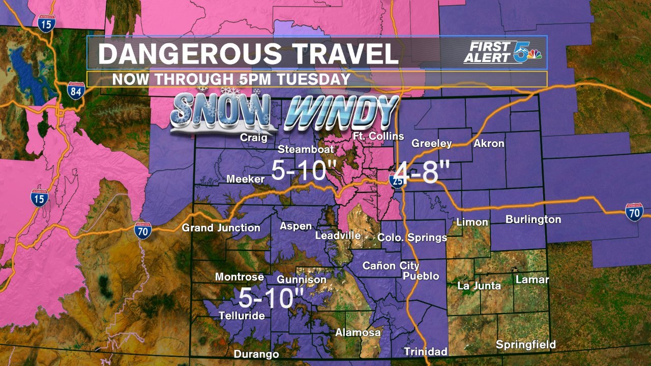
A Winter Weather Advisory is in effect for most of our viewing area through early Tuesday evening. Some spots could see as much as 4-8" of snow.
COLORADO SPRINGS: Low: 8; High: 16. Cold and snowy Tuesday morning, with decreasing snow showers by the afternoon. Snow will linger over the eastern slopes and northern suburbs later than those living closer to the city center. Snow totals from 2-5".
PUEBLO: Low: 10; High: 20. Morning snow and wind will lead to a slick and hazardous morning commute on Tuesday. Snow showers should taper off by late morning to early afternoon, with a dry and very cold night to follow. Snow totals from 1-4".
CANON CITY: Low: 12; High: 21. Snow, heavy at times tonight will continue through Tuesday. Periods of snow will linger into Tuesday afternoon, lightening up by the evening. Snow totals from 4-7".
WOODLAND PARK: Low: 3; High: 10. Significantly colder air coupled with periods of snow on Tuesday will make for a wintry mess in the forecast. Wind will also be gusty at times, with blowing snow a concern in Teller County. Snow totals from 4-7".
TRI-LAKES: Low: 0s; High: 10s. Tuesday will be a cold and snowy mess over northern El Paso County. Temperatures will struggle to warm into the lower teens, with snow and blowing snow a factor in the forecast through the afternoon. Snow totals from 4-8".
PLAINS: Low: 10s; High: 20s. Cold and cloudy on Tuesday, with high temperatures only warming into the lower to middle 20s. No weather alerts have been issued as of this evening for the Plains, with snow totals generally expected to range between 1-3".
WALSENBURG/TRINIDAD: Low: 10s; High: 10s. Tuesday will be cold and snowy. Most of the snow will fall through the overnight and morning hours, with snow tapering by the afternoon. Snow totals from 2-5" for Walsenburg, and 3-6" for Trinidad.
Extended Outlook: Tuesday night will be very cold, with dangerously low wind chill values expected across Southern Colorado. Wednesday morning will start out with temperatures in the single digits and negatives. Wind chill temperatures down to 15 to 30 below zero across the region. Sunny skies and cold highs Wednesday will give way to a gradual warming trend through the end of the week, with seasonal temperatures returning by Thursday. Friday looks a little cooler as a system that favors the mountains with heavy snow could bring some light snow showers to the Pikes Peak Region as we wrap up the week. The weekend looks warmer and breezy, with our next chance for snow arriving early next week.
