


Tonight's Forecast:
Temperatures Tuesday night will be relatively mild, with a downsloping west wind keeping temperatures warmer than normal. There will be a chance of light snow in the mountains overnight but with light accumulations.
Wednesday Forecast:
Our next winter storm arrives on Wednesday. Winter Storm Warnings and Winter Weather Advisories will be in effect from Wednesday until Friday. On Wednesday, there will be a mix of rain and snow, eventually transitioning to snow for most of the region on Wednesday night. Snow continues all day Thursday then gradually comes to an end Friday.

Colorado Springs forecast: Low: 38; High: 44;
Wednesday will be mostly cloudy with a rain/snow mix and lightning possible during the day, transitioning to snow overnight. A WINTER WEATHER ADVISORY goes into effect at midnight Wednesday night and will last until noon Friday.
Pueblo forecast: Low: 40; High: 58;
There is a chance of rain and thunderstorms on Wednesday afternoon, eventually transitioning to snow showers late Wednesday night. A WINTER WEATHER ADVISORY goes into effect at midnight Wednesday night and will last until noon Friday.
Canon City forecast: Low: 37; High: 55;
A chance of rain and thunderstorms on Wednesday, with a wintry mix in the evening that will transition over to snowfall at night. A WINTER WEATHER ADVISORY goes into effect at midnight Wednesday night and will last until noon Friday.
Woodland Park forecast: Low: 27; High: 38;
Light snow is possible before sunrise Wednesday, with cloudy conditions otherwise in the morning. Snow will ramp up in the early afternoon and continue throughout Wednesday. A WINTER STORM WARNING goes into effect at 6 am Wednesday and lasts until 6 am Friday.
Tri-Lakes forecast: Low: 32; High: 37;
A wintry mix is possible during the day on Wednesday, with a stray lightning strike possible as well. Roads will be just wet during the day. Full snow is expected by Wednesday evening and continues overnight. A WINTER STORM WARNING goes into effect at 6 pm Wednesday and lasts until 6 am Friday.
Plains forecast: Low: 30s/40s; High: 50s/60s;
Rain showers and isolated thunderstorms are possible on Wednesday, with a wintry mix possible on Wednesday night. Otherwise, it will be a cloudy day tomorrow.
Walsenburg and Trinidad forecast: Low: 36/38; High: 52/54;
Cloudy on Wednesday with rain possible in the afternoon, transitioning to a wintry mix in the evening and eventually snow on Wednesday night. A WINTER STORM WARNING goes into effect at 6 pm Wednesday and lasts until 6 pm Friday.
Mountains forecast: Low: 20s/30s; High: 30s/40s;
A WINTER STORM WARNING goes into effect at 6 pm Wednesday and lasts until 6 am Friday for western Fremont County and the Wet Mountain Valley. It will last until 6 pm Friday for the Sangre De Cristos and Wet Mountains.
Extended outlook forecast:
Snow continues across the region on Thursday with a wintry mix in the eastern plains. Snow will start to pile up and create hazardous travel conditions, especially in the foothills and on main highways like HWY 50, 24, and I-25. The snow will come to an end gradually on Friday from north to south. Expect travel to still be tough on Friday, especially between Denver and Colorado Springs and in the mountains.
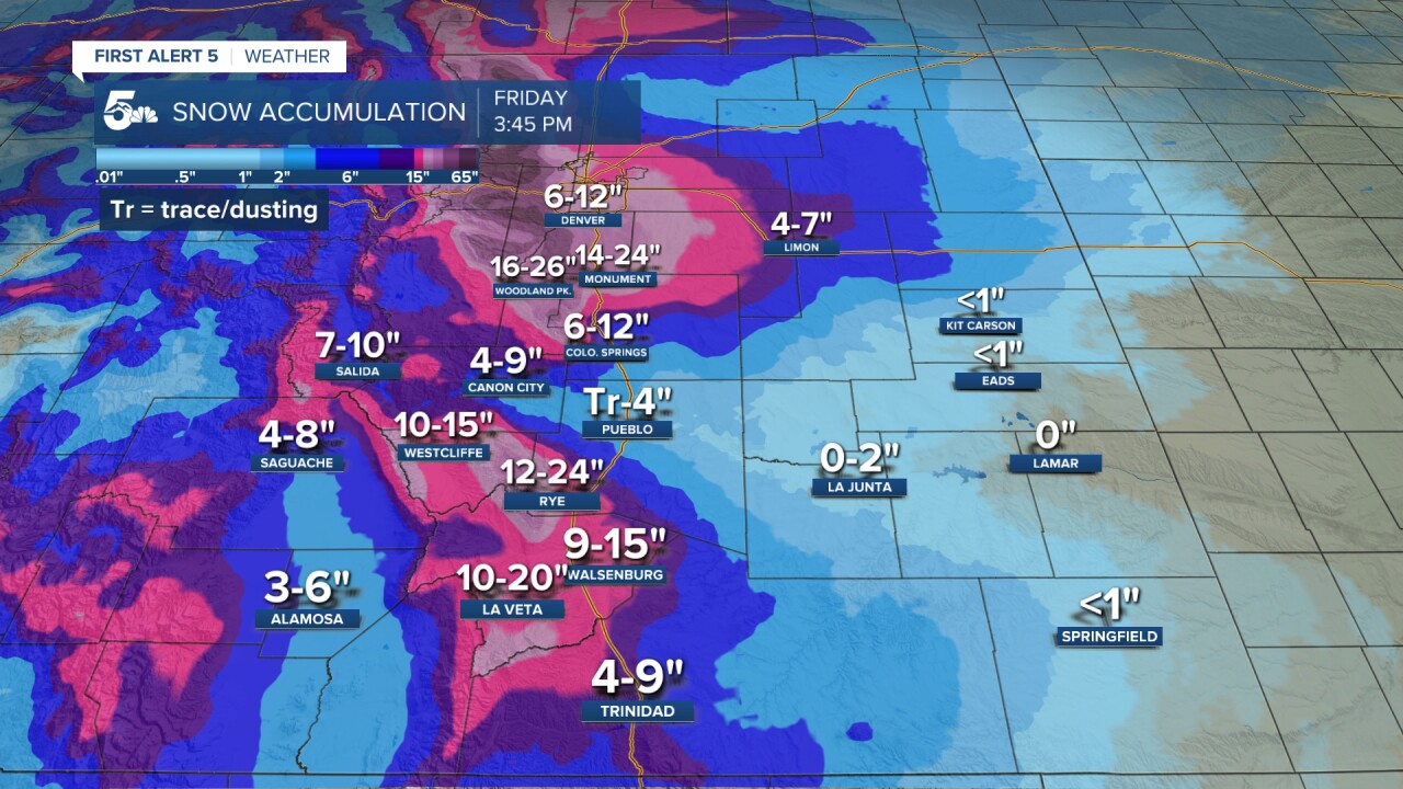
Expected snowfall through Friday:
____
Curious about the First Alert 5 Weather Storm Impact Scale? Check out our cheatsheet explainer.
Watch KOAA News5 on your time, anytime with our free streaming app available for your Roku, FireTV, AppleTV and Android TV. Just search KOAA News5, download and start watching.
