


Tonight's Forecast:
Temperatures are expected to drop into the 30s for most around southern Colorado, which is still a few degrees above where we should be this time of year. Clear skies with minimal wind prevail as well.
Colorado Springs forecast: Low: 37; High: 58;
Friday will be slightly cooler than today with highs expected to be in the upper 50s around Colorado Springs. Partly cloudy skies are expected across the area as well with calm wind. That's ahead of a cooler weekend with a loose shower chance.
Pueblo forecast: Low: 33; High: 62;
Another day of above average temperatures is ahead for Friday with low 60s in the forecast. A few more clouds are expected through Friday afternoon. The weekend will cool a bit further.
Canon City forecast: Low: 42; High: 63;
Low 60s are expected across the area with some clouds on Friday. The weekend brings in a bit more of a cool down with increased atmospheric moisture, especially on Saturday.
Woodland Park forecast: Low: 33; High: 54;
Woodland Park and Teller county will drop a few degrees for Friday with mid 50s in the forecast. More cooler temperatures with a few snow and rain showers possible as the weekend starts.
Tri-Lakes forecast: Low: 36; High: 59;
A similar story is ahead for Friday for the Tri-Lakes with cooler temperatures for Friday. Saturday will bring in cooler temperatures in the low 50s and 40s for some. A few chances for cool rain are in the forecast for Saturday with some of the higher elevation areas of the Palmer Divide seeing a few snowflakes.
Plains forecast: Low: 34; High: 63;
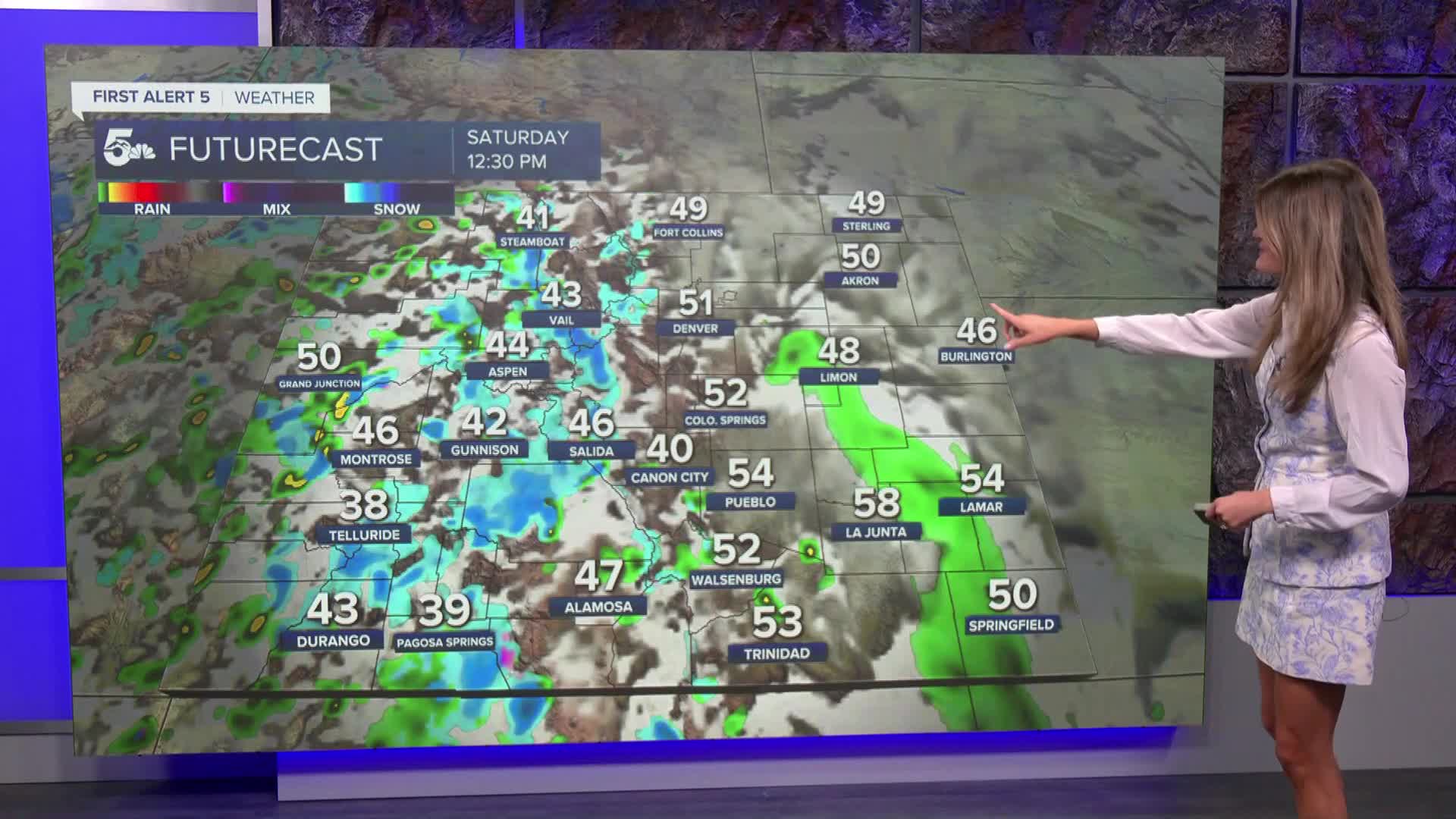
Friday will be partly cloudy and warmer than averages. The weekend brings in rain chances for the plains on Saturday afternoon and evening for the plains with slightly cooler temperatures.
Walsenburg and Trinidad forecast: Low: 41; High: 61;
After the partly cloudy, dry and mild Friday a few changes will roll in for the weekend. A cool down is expected with temperatures likely to drop to be more seasonal or even below seasonal. A few chances for showers could be possible in Huerfano and Las Animas counties by Saturday too.
Mountains forecast: Low: 31; High: 47;
Friday will bring in more clouds for the mountains with slightly cooler temperatures. Saturday brings in more atmospheric moisture with rain along the western slope and snow for the central and southern mountains. Decent high country snow accumulation is possible with several inches in the forecast. The moisture clears out for early next week as temperatures stay cool.
Extended outlook forecast:
The weekend will bring in increased atmospheric moisture with a few shower chances on Saturday afternoon, especially for the plains. Later in the day some models are indicating a few shower chances for the I-25 corridor, but I think we will likely trend a little bit drier as we get closer to Saturday. Good mountain snow is expected by then as well. Sunday and into early next week with dry back out as cooler temperatures stick around. By the middle of next week some more changs in the high country could move back in. Details to come...
____
Curious about the First Alert 5 Weather Storm Impact Scale? Check out our cheatsheet explainer.
Watch KOAA News5 on your time, anytime with our free streaming app available for your Roku, FireTV, AppleTV and Android TV. Just search KOAA News5, download and start watching.
