

Tonight's Forecast:
A cold front blows through the plains overnight, bringing a sharp change to northerly winds gusting 30-50 mph through Thursday morning. Overnight low temperatures will remain mild, but the high temperatures will cool in the plains by about 10 degrees on Thursday.
Thursday Fire Danger:
The cold front does not bring higher humidity with it, so unfortunately, even with the cool down, fire danger remains high with the gusty winds on Thursday. A RED FLAG WARNING is in effect from 11 am until 6 pm for Crowley, Kiowa, Bent, and Prowers Counties, and from 2 to 8 pm for Fremont, Pueblo, eastern Huerfano, and central Las Animas Counties.

Colorado Springs forecast: Low: 54; High: 80;
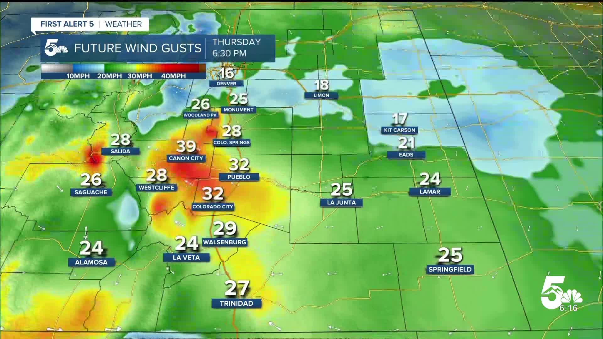
It will be mostly sunny with an average high temperature on Thursday. Wind will be out of the NNE at 10-15 mph, gusting to 35 mph.
Pueblo forecast: Low: 59; High: 87;
RED FLAG WARNING from 2-8 pm. It will be sunny and gusty on Thursday with ENE wind at 15 mph gusting to 30 mph.
Canon City forecast: Low: 60; High: 83;
RED FLAG WARNING from 2-8 pm. Thursday will be sunny and dry with gusty wind out of the ENE at 10-15 mph gusting to 35 mph.
Woodland Park forecast: Low: 45; High: 73;
It will be a warm and sunny Thursday. Wind will be out of the NW at 10 mph gusting to 30 mph.
Tri-Lakes forecast: Low: 48; High: 75;
It will be sunny and warm on Thursday with NE wind at 10-15 mph gusting to 30 mph.
Plains forecast: Low: 50s-60s; High: 70s-80s;
RED FLAG WARNING from 11 am - 6 pm for Crowley, Kiowa, Bent, and Prowers Counties. Wind will be out of the NE at 10-20 mph, gusting 25-45 mph.
Walsenburg and Trinidad forecast: Low: 59/58; High: 80/83;
RED FLAG WARNING from 2-8 pm. It will be sunny and dry on Thursday with gusty wind out of the NNE at 10-15 mph gusting to 30 mph.
Mountains forecast: Low: 40s-50s; High: 70s-80s;
The mountain valleys will be warm and mostly sunny on Thursday. Wind will be variable at 10-15 mph, gusting 25-35 mph.
Extended outlook forecast:
On Friday it will be sunny and breezy once again with temperatures boosting back up to the 80s and 90s across the region. The weekend starts with heat on Saturday, but a few afternoon showers and thunderstorms are possible. A stronger cold front and surge of moisture arrive on Sunday, bringing widespread rain and thunderstorms.
____
Curious about the First Alert 5 Weather Storm Impact Scale? Check out our cheatsheet explainer.
Watch KOAA News5 on your time, anytime with our free streaming app available for your Roku, FireTV, AppleTV and Android TV. Just search KOAA News5, download and start watching.
