

Today’s Forecast:
Happy New Year!
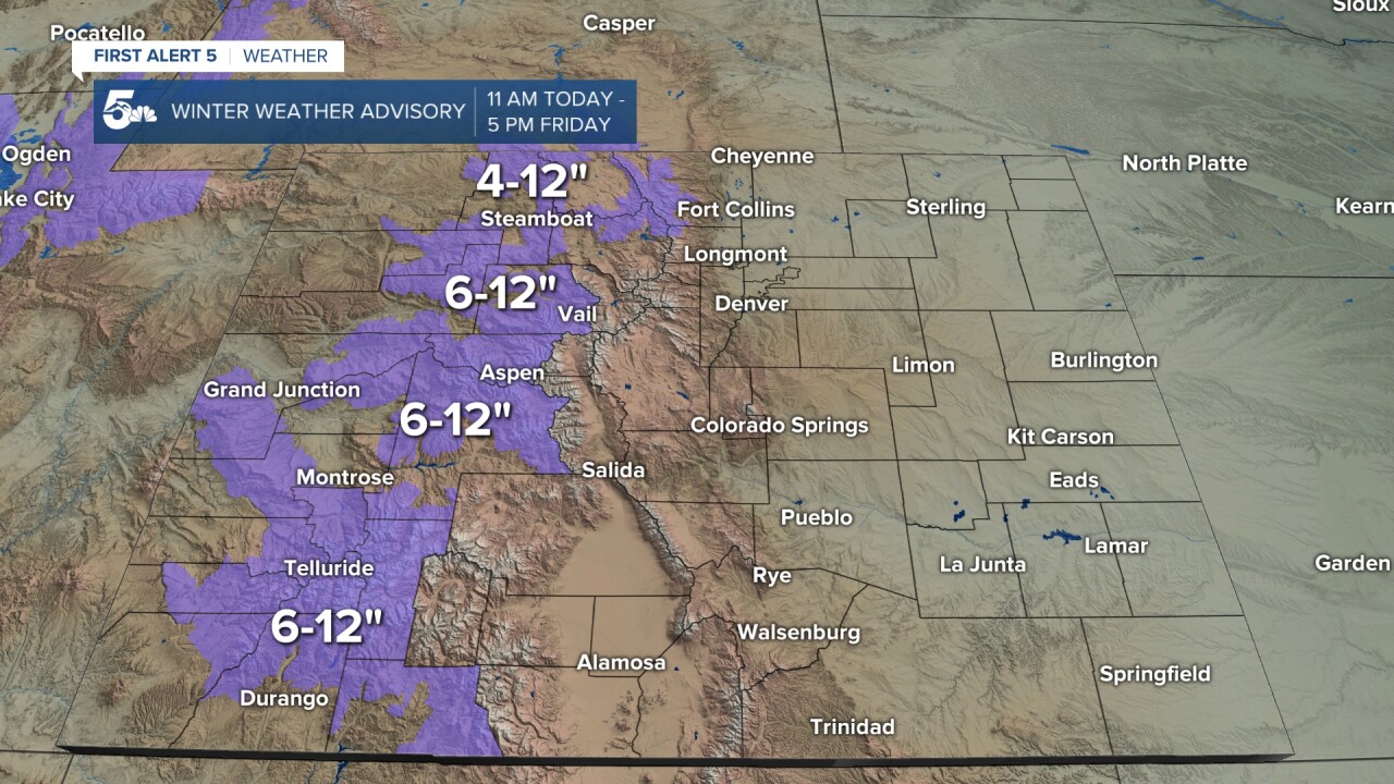
2026 will begin with a strong storm moving into Colorado from the West Coast. This storm has prompted Winter Weather Advisories for many of our state's mountain ranges, with these advisories going into effect at 11 am, and continuing until 5 pm Friday. It will be windy in the high country, with 6-12" of accumulation possible over the next 24-48 hours. Travel into and out of the mountains may become difficult during periods of heavier snow and wind.
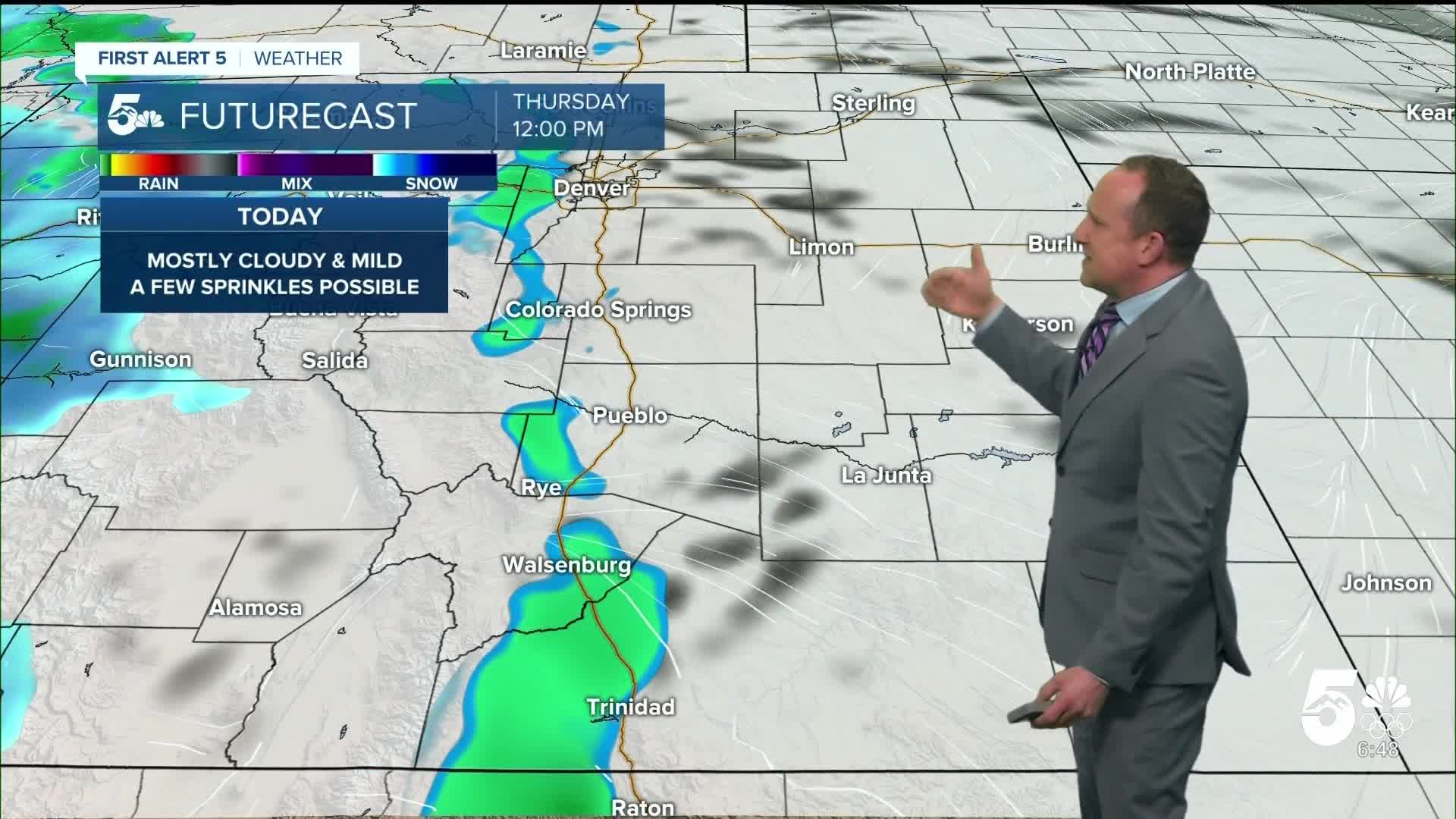
On the Plains today, it will be mostly cloudy and mild. There's some indication that a few showers may make it east of the mountains late this morning or this afternoon. Chances appear pretty low because westerly wind at the surface is not conducive to moisture for the lower elevations. However as the atmosphere moistens up later today, a few showers will be possible along and near I-25.
Colorado Springs forecast: High: 62; Low: 34. Mostly cloudy to cloudy skies and mild highs can be expected in the Pikes Peak Region on this first day of 2026. As moisture increases throughout the day, we can't rule out a few sprinkles or a rogue shower here this afternoon.
Pueblo forecast: High: 65; Low: 32. 2026 will begin just as 2025 ended, warm! On top of highs in the 60s, today will be cloudy, with a slight chance of a shower this afternoon in the Steel City.
Canon City forecast: High: 64; Low: 40. Not just mild, but it's going to be warm again on New Year's Day, with highs in the middle 60s and a small chance of a shower this afternoon.
Woodland Park forecast: High: 54; Low: 33. Skies will be mostly cloudy on New Year's Day, with temperatures this afternoon warming into the lower to middle 50s. While snow will fall today to our west, we could see a rain shower or sprinkle in Teller County...in January!
Tri-Lakes forecast: High: 50s/60s; Low: 30s. As we start the new year, we'll see another unusually warm day across Southern Colorado, with highs today in the upper 50s and lower 60s in northern El Paso County. Moisture will move east of the mountains today, with a slight chance of a shower this afternoon.
Plains forecast: High: 60s; Low: 20s/30s. Warm, mostly cloudy and breezy on the Plains for this first day of 2026. NW winds will be sustained at around 10-20 mph, with gusts to 25 mph in some areas this afternoon.
Walsenburg and Trinidad forecast: High: 60s; Low: 30s. It's been mild this morning, with a few showers on Radar in Las Animas County. The rest of our day will overcast and warm, with highs today in the upper 50s and 60s, and a chance for isolated showers this afternoon.
Mountains forecast: High: 30s/40s; Low: 20s/30s. Winter Weather Advisories will go into effect today at 11 am from the San Juans through the central mountains and Park Range. Excluded from today's advisories are the Wet Mountains and Sangres. Here locally, it will be windy and mostly cloudy today, with occasional light snow showers possible.
Extended outlook forecast:
After a pretty cloudy start to 2026, Friday's forecast will feature decreasing clouds and a return to 50s and 60s. Mountain snowfall will continue during the day as a Winter Weather Advisory remains in effect until 5 pm.
Mostly sunny and mild weather will continue on Saturday, with a high in the upper 50s in Colorado Springs, and a few degrees of cooling region-wide. Sunday will be a bit cloudier and with more wind, warmer. Downslope wind gusts to 30 mph will also bring a new threat of elevated fire danger to parts of Southern Colorado late this weekend. Our highs on Sunday will top out in the middle 60s to lower 70s on the Plains.
____
Curious about the First Alert 5 Weather Storm Impact Scale? Check out our cheatsheet explainer.
Watch KOAA News5 on your time, anytime with our free streaming app available for your Roku, FireTV, AppleTV and Android TV. Just search KOAA News5, download and start watching.
