

Today’s Forecast:
High pressure to our southeast will keep that significant storm that's battering California this morning off to our west. In the mountains, early morning snow showers will taper off around sunrise, with the potential for snow holding off until later this evening.
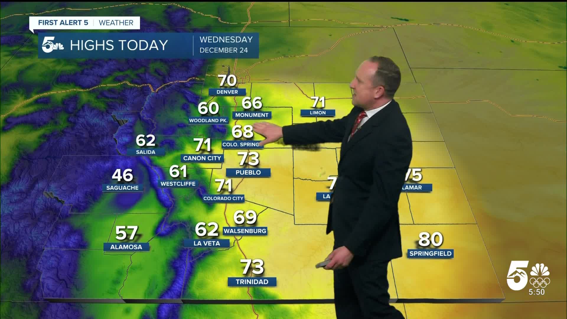
On the Plains, near-record warm temperatures will remain in the forecast today. Highs will warm into the 60s and 70s on the I-25 corridor, with 70s and lower 80s out east. Early morning downslope breezes are already keeping many well above average this morning, and highs today will be as much as 20-25 degrees above normal.
Colorado Springs forecast: High: 68; Low: 41. Above average temperatures can be expected once again on Christmas Eve in Colorado Springs, with today's high of 68 degrees expected to threaten today's record of 70, last set in 1955.
Pueblo forecast: High: 73; Low: 38. Record breaking heat on Monday gave way to a slight dip in temperatures on Tuesday, but the cool down will be short lived as today's highs return to the 70s. Current record: 76° (1955).
Canon City forecast: High: 71; Low: 43. The calendar may say that it is Christmas Eve, but with highs in the 70s, it will feel a lot more like October than late December.
Woodland Park forecast: High: 60; Low: 35. This morning, temperatures have been in the 40s, which is wild for late December. Even crazier is my forecast for lower 60s this afternoon in Woodland Park.
Tri-Lakes forecast: High: 60s; Low: 40s. While the calendar says that Christmas is here, our forecast says otherwise, with dry skies and 60s this afternoon across northern El Paso County.
Plains forecast: High: 70s/80s; Low: 30s/40s. Outside of a few cooler days that we've seen this month, most of December has been warm on the Plains. Today will follow those warmer trends, with our highs today soaring into the 70s and lower 80s.
Walsenburg and Trinidad forecast: High: 60s/70s; Low: 30s/40s. Breezy to gusty and warm on Wednesday, with gusts to 35 mph in wind prone areas on the eastern slopes of the Wet Mountains and Sangres.
Mountains forecast: High: 40s; Low: 20s. Dry skies will continue in the Wet Mountains and Sangres today, with increasing snow showers later tonight in the San Juan Mountains. Wind gust this evening will increase to near 45 mph.
Extended outlook forecast:
The wind will increase region-wide on Christmas Day, with afternoon wind gusts to 35 mph. Temperatures will warm into the upper 60s in Colorado Springs on Christmas Day, with our current record sitting at 67 degrees on Thursday. Pueblo and many areas on the Plains will see a return to 70 degree plus temperatures.
Friday's highs will warm into the lower 60s, with upper 50s by Saturday. Each day through Saturday will be breezy, with SW wind gusts to 30 mph.
A potent cold front will arrive Saturday night, dropping highs down to the upper 30s in Colorado Springs by Sunday. Behind the front, we could also see a few snow showers late Saturday into Sunday morning. Model consensus is growing that we could see at least a few flakes in Colorado Springs. Accumulations will be very light at best, with little impacts to travel. Stay tuned for more details late this week and Merry Christmas everyone!
____
Curious about the First Alert 5 Weather Storm Impact Scale? Check out our cheatsheet explainer.
Watch KOAA News5 on your time, anytime with our free streaming app available for your Roku, FireTV, AppleTV and Android TV. Just search KOAA News5, download and start watching.
