


Arctic air is heading for Colorado this weekend, and if you thought the last few days were cold, you haven't seen anything yet!
Quick Forecast:
The coldest air of the year is expected to move in this weekend. Temperatures will be in the teens and low 20s Friday and Saturday, but single digits and even a few negatives by Sunday.
Light snow is expected to follow the cold Saturday night through Sunday, but there could be occasional light flurries or freezing fog from Friday through Monday.
Why is it so cold?
This invasion of arctic air is happening for a few reasons, but one of the main factors is the "polar vortex".

The polar vortex is a constantly spinning area of low pressure and cold that usually hangs out around the center of Earth's north and south poles.
During the summer months, the vortex tends to be stable, keeping all the low pressure and cold up north around the top of the globe.

In the winter, the polar vortex can become a but more unstable. The jetstream above us separating the warm and cold air can sag farther south, allowing arctic air from the north pole to penetrate farther south into the United States.
This is a fairly common occurrence during the winter, but to have such a cold airmass moving this south for this long is a bit more uncommon.
How cold are we going to get?
We're still figuring this one out, but even the "warmest" estimated temperatures for southern Colorado look super cold!

Shallow arctic air will have trouble climbing up the mountains through the weekend, so the coldest air will stay east of the Front Range and below areas of 7,000 feet, like Monument Hill.
The coldest day of the weekend looks to be on Sunday. High temperatures will be in the single digits across the plains, if not negatives in a few areas.

Even colder are the temperatures that will follow Sunday afternoon into Monday morning.
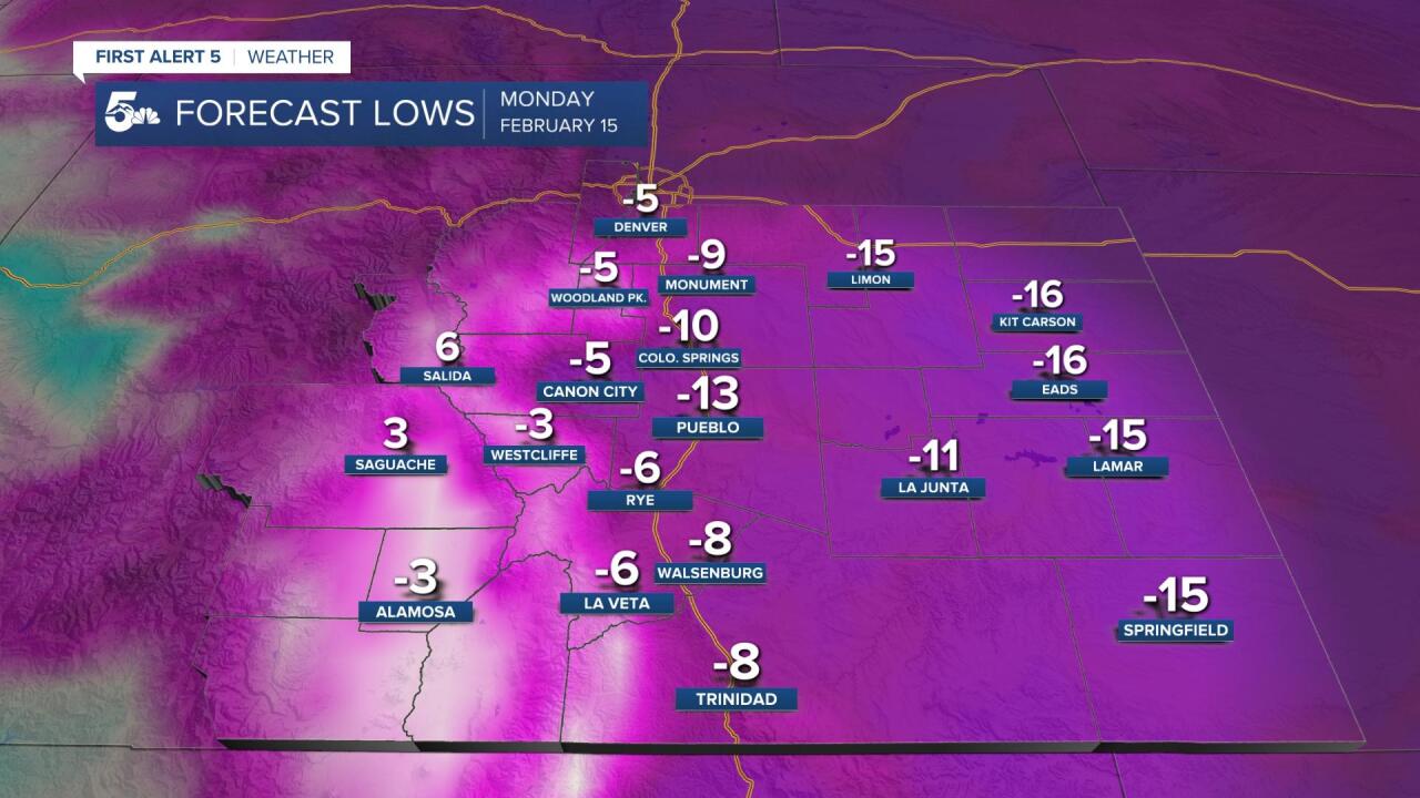
Lows in the plains will be well below zero Sunday night, and even a light wind could lead to wind chills 20 to 30 degrees below zero.

Snow is forecast to fall through the weekend, starting Saturday afternoon and ending Sunday. Cold air should help create a fluffy snow flake, but there isn't much moisture to work with here, so totals could really come in on the low end across the region.
Frostbite dangers in extreme cold
Frostbite can occur within 30 minutes of exposure to wind chills in the -20° F range.

Wind chill temperatures may dip between -15° to -20° Sunday night for multiple hours. It is vital that all people and animals are in shelter during these hours.

For those venturing out in the subfreezing temperatures this weekend, it is recommended to have 3 or 4 layers of clothing. Wear insulating layers underneath and waterproof layers on top. Hats, mittens, and face coverings will be necessary.
These sub-zero temperatures approaching are forcing the City of Pueblo to expand the Emergency Warming Shelter's hours of operation. Pueblo's Transit Center downtown opened earlier in the week from 6 p.m. to 6 a.m., providing shelter to the homeless people who need it.
