


DENVER — Across Colorado's Rocky Mountains, you can find enormous and striking displays of glacial geology — proof that glaciers past and present are powerful sculptors of the landscape.
But from their alpine perches, these powerhouses — small as they may be compared to their relatives in Greenland and Antarctica — are weakening and altering under continually rising summer temperatures.
Photos collected by Denver7 throughout the summer and early fall of 2022 show glaciers around Colorado retreating in ways that have startled local researchers. And while visitors may feel shocked seeing barely a strip of ice at St. Mary's Glacier or Isabelle Glacier, a photo only tells so much of the story.


Dan McGrath, an assistant professor in Colorado State University's Department of Geosciences, explained that no single year should set off alarms. Glaciers must be analyzed in the context of much longer periods of time.
Having said that, the past couple summers have not been encouraging.
"For these last two summers for Colorado glaciers, the fact that there has been bare ice — they're obviously thinning and they're retreating. That's concerning," McGrath said. "We want to monitor them in the long run, understand how they're changing."
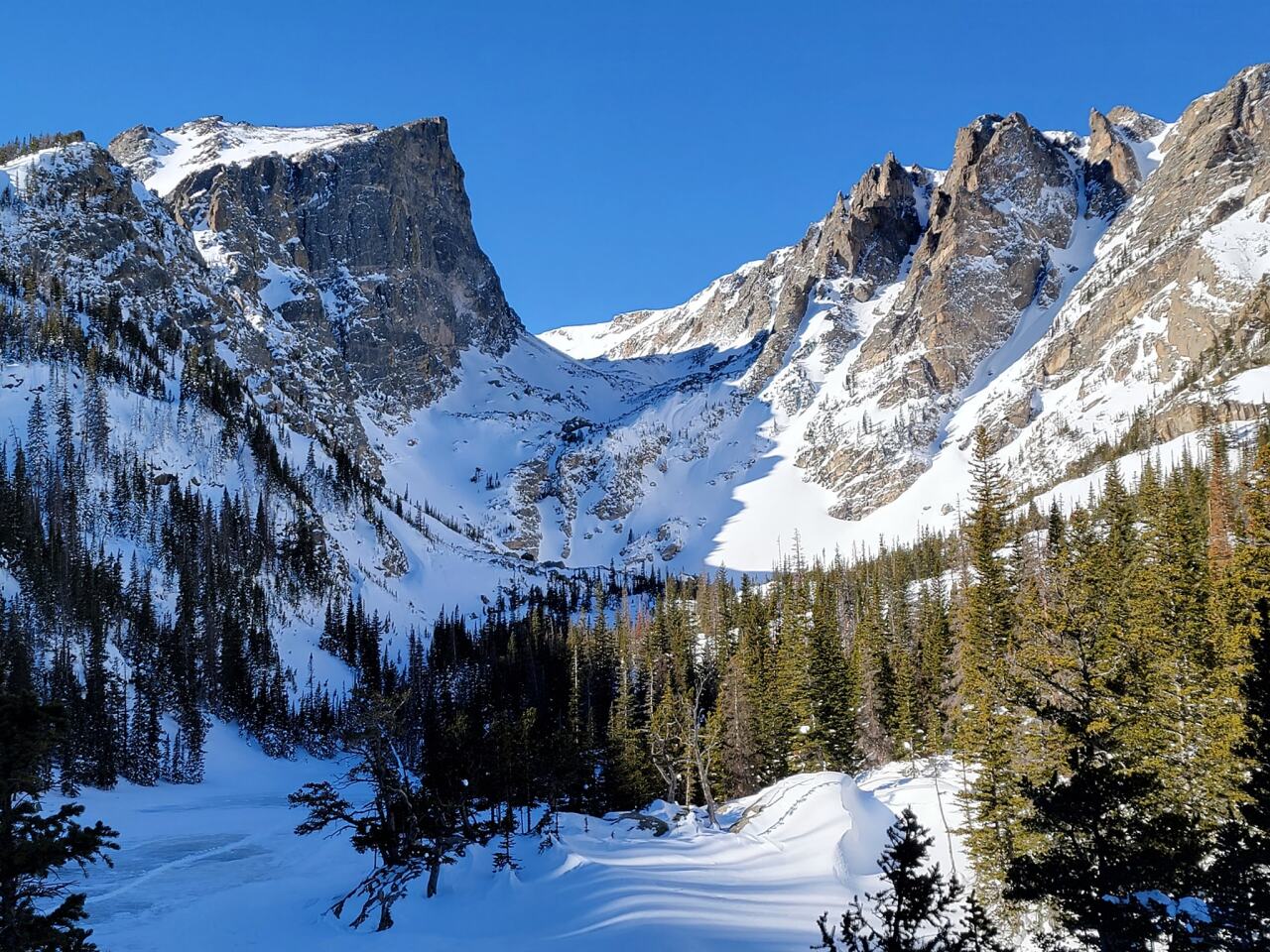
If you hiked up to one of the state's glaciers in the past few summers, you likely ventured out to seek the unique views — a forest that gives way to rocky terrain partially covered by ice and snow, dribbling down to a glacial lake. It's beloved, quintessential scenery in the Rocky Mountains.
"Here in Colorado, you know, these are iconic features that people seek out, they hike to. They’re destinations," McGrath said. "And we're seeing significant changes that raise concern about how much longer they'll reside in the landscape."
The must-knows about Front Range glaciers
If you didn't realize Colorado has glaciers, you're not alone. They are quite different from the glaciers that typically come to mind — the ones that spill out for miles near the poles.
All glaciers exist in areas where the mean annual temperature is close to freezing and winter precipitation is mostly snow, according to the U.S. Geological Survey (USGS). The mix of crystalline ice, snow, rock, sediment, and often liquid water must move downslope under its own weight and the pull of gravity. As they slowly slide, they pick up rocks, sand, and gravel, which are all pressed down by the tons of ice on top of it, and then scrape into the terrain.
In simple terms, glaciers are frozen rivers flowing downhill.
Earth is home to more than 200,000 glaciers, with about 1,200 of them in the American West, and 16 scattered across the Front Range in Colorado, according to the USGS’s Geographic Names Information System.
As listed by the USGS, Colorado's official glaciers are:
- Andrews Glacier (hiking information)
- Arapaho Glacier (hiking information)
- Arikaree Glacier
- Fair Glacier
- Isabelle Glacier (hiking information)
- Mills Glacier (hiking information)
- Moomaw Glacier
- Navajo Glacier
- Peck Glacier
- Rowe Glacier
- St. Mary’s Glacier (hiking information)
- Saint Vrain Glacier (hiking information)
- Sprague Glacier
- Taylor Glacier
- The Dove
- Tyndall Glacier
While USGS has identified these as glaciers, McGrath acknowledged that, in academic circles, many of them may be better classified as perennial ice fields, the main difference being that ice fields are too thin to actively flow. The number of Colorado glaciers that are active, or flowing under their own weight, is likely five or less, McGrath said, but that distinction only truly matters within academia.
The state's glaciers are nestled in cirques — small bowl-like valleys that look almost like somebody used a huge ice cream scooper against the rock — at or above 12,100 feet on slopes that face east to northeast.

The cirque glaciers are unique in that their accumulation comes mostly from snow pushed by wind or avalanches.
Because they are protected from westerly winds and downwind of large peneplains — featureless low-angled terrain — strong winds sweep the plains of any new accumulation and deposit it on the nearby glacier each winter, McGrath explained.

In some cases, it lends to glaciers seeing accumulation rates much higher than actual snowfall. In one case, McGrath remembered, that wind distribution process left Andrews Glacier with up to 16 meters of snow.
In the warmer months, the glaciers are relatively shaded from the sun, which, to an extent, helps slow summer melt. The Glaciers of the American West reported "it is highly unlikely that any of Colorado's glaciers could exist today without the benefit of these local topographic effects."
Bruce Raup, senior associate scientist with the National Snow and Ice Data Center (NSIDC) in CU Boulder's East Campus, said the small cirque glaciers nourished by windblown snow are a little bit less sensitive to the hot summers because their accumulation is typically so high every year.
The so-called "refugia effect" is far from impenetrable, though.
"But having said that, these glaciers can, if they experience a couple of warm summers in a row like this year and last year, they can really lose a lot of ice in a quick time," Raup said. "So I don't think the prognosis for Colorado glaciers is very good. I think in a few decades they'll basically be gone."
An in-depth look at the current state of Colorado's glaciers
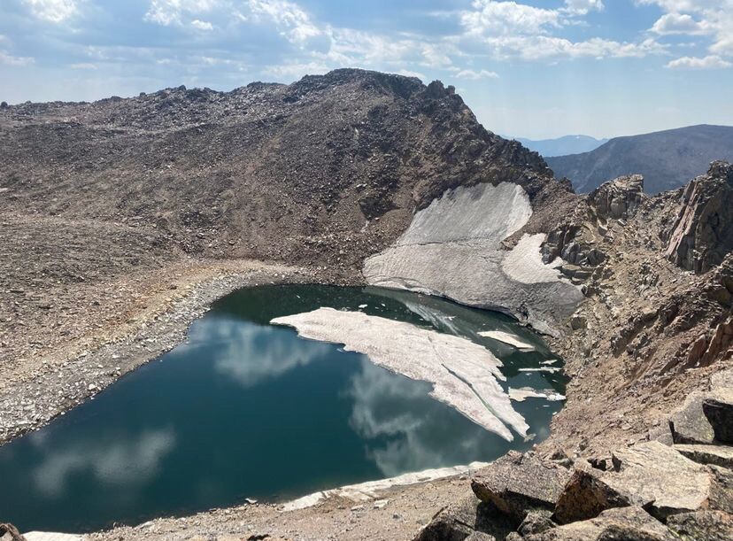
Even with the unique natural features and protections around Colorado glaciers, they are still thinning. It's clear even to the untrained eye of this reporter, who reached out and sent a photo to McGrath after seeing the state of Isabelle Glacier in the Brainard Lake Recreation Area in early September.


In response, McGrath called the image "startling," adding, "this is as bare as it goes, with no seasonal snow left." He sent Denver7 a photo of the glacier from almost exactly two years prior that makes it look much healthier. But he explained how a picture can only say so much.
"When we look at a photograph, that seasonal snow may make the glacier appear like it's quite large. But it's just a thin veneer of seasonal snow — maybe three feet or a couple of feet thick," he said. "And in reality, there's no ice underneath there. And really what we're interested in is how much ice is there and how that's changing through time."
After diving into current and past satellite imagery of several of Colorado's glaciers, he explained what he knew about their current states.
"I was interested to see, you know, how common was this in the recent past," he said from his office at CSU. "Here we’re relying on both Landsat and Sentinel satellite imagery and tracking the glacier surface through time."
He pointed at a set of satellite images of Isabelle Glacier, all taken on cloudless days in mid-September, and described the bright sections as seasonal snow and darker, grayish parts as bedrock.

2018 showed some bare ice while 2019 and 2020 showed largely seasonal snow-covered glacier conditions at the end of the summer. Both 2021 and 2022 had significantly more gray.
That data tells the story of a couple healthy years followed by summers of bare ice.
"And this is a trend that's apparent at all the glaciers along the Front Range," McGrath said.

Within the week of Denver7 reaching out with the Isabelle photo, McGrath hiked up to the Moomaw Glacier on the southern edge of Rocky Mountain National Park to see conditions for himself.
"The neat thing from a scientific perspective and somewhat alarming thing from a public perspective is that this glacier has undergone significant change," McGrath said of Moomaw. "And it's really transitioning away from being an ice patch or perennial kind of snowfield almost into what we call a rock glacier, or at least a debris-covered glacier."
The majority of the glacier surface is covered in talus and rockfall, which actually helps reduce melt rates on the ice under the rock, McGrath explained.

"There will likely be the persistence of ice in portions of this basin for much longer than if it was just clean ice and exposed to the elements, but this is not what we think of as a glacier," he said. "You know, I would not walk up to this and say, 'Oh, here's another glacier in Colorado.'"
He has seen major changes at Rowe Glacier as well, which is unique in that it has a large body of water at its terminus and a sizable floating piece, he said. The Rocky Mountain National Park glacier has always had that afloat aspect, he explained, though it has been shrinking in past years.
"And then the remarkable thing this summer is that this floaty extent is detached — it's no longer connected to that glacier," he said.
McGrath has spent several years studying Andrews Glacier, also in Rocky Mountain National Park, and during a Sept. 26 interview, said the feature "was really looking rather dismal" when he visited it a few days prior.
"On Friday, seeing Andrews was eye-opening to me, just having studied it so long, and just having been up there so many times and just seeing this static feature in every other trip," he said. "And just really witnessing with my own eyes just how significant this change is."
"In all the years that I have been up there and all the photographs that I've seen, I've never seen the terminus as far retreated as this," he continued. "Now I wouldn't hang my hat on just this one observation. You know, next year, the next subsequent years, could be really big accumulation years and these glaciers can have more mass added to them. But what appears here is a trend that this glacier is thinning and obviously retreating in its extent."

About 17 miles south of Andrews is Arikaree Glacier, in the Roosevelt National Forest. A January 2016 report from the Associated Press said that this glacier could disappear in about 14 years due to regional climate warming and drought, adding that it has been thinning by about one yard a year for 15 years.
Arapaho Glacier near Nederland in Boulder County has been undergoing a similar loss of ice, according to data trends from 2015 through 2022, McGrath said.
"Arapaho has a lot of kind of south-facing aspects to it," McGrath said. "And so it actually experiences really high rates of melt on that glacier surface. And so it's not uncommon for there to be bare ice on the glacier, yet there's portions here on the north-facing sides that almost always have snow."

According to a study and subsequent high-resolution 3D model McGrath helped research and create in 2021 at the glacier, it had thinned by more than 60 feet over a 16-year period starting in 2005.
"That's really quite significant in the grand scheme of things," he said.
According to satellite imagery from 2021 and 2022, Arapaho Glacier had significantly more bare ice than any other year on record and no seasonal snow left in the basin.
"But just that's indicative of just how warm the summer has been, or potentially how little snow fell," McGrath explained. "And that's really what we look at when we're trying to understand these glaciers from a relatively simplistic sense."

Given the in-depth data available to researchers today, are Colorado's glaciers in trouble or have the past few summers been anomalies?
It's a question experts are working to answer. But Raup said the short explanation is that glaciers are shrinking everywhere and will likely continue to do so.
"And they might retreat into the shaded areas and kind of hang around in small vestiges of themselves for a while," he explained. "But given the increased frequency of warmer, hot summers, like we've been having, it won't take much to have a lot of thinning in a short period of time."
How do researchers measure the health of Colorado's glaciers?
In simplest terms, glacier health is measured by their mass balance, or the sum of how much snow is added to the glaciers minus how much snow and ice melts the following summer.
Year after year after year of negative mass balance — more melting than accumulating — will eventually result in their disappearance.
"Those numbers give us kind of a background to say, 'OK, how long, if we look at the current thinning rates at these glaciers, how much longer could they persist?'" McGrath said. "We can't necessarily assume that that is going to be linear. We could have a number of really big winters in a row where, you know, 45 feet of snow get added to these glaciers. And they may be OK for a handful of years. But the overall warming trend that we're seeing here is causing these glaciers to thin and to retreat over time."

That information can lead scientists toward predicting how much longer these glaciers will survive.
During the wintry months, researchers use resources like SNOTEL (SNOpack TELemetry), autonomous stations in the Front Range that measure snow, to plot out long-term trends, including snow water equivalent (SWE), which is how much water is stored in the snowpack. 2020 was a large year for SWE, 2021 showed slightly above average, and 2022 was about 10-15% below average, McGrath said.

"And these last few winters have been close to average, nothing kind of remarkable. Not huge years, not small years. Just kind of average," McGrath said. "But what really has been distinct over these last few summers has been the summer temperatures."
In fact, a 2017 study from Cambridge University recently found that changes in winter snowfall has minimal impacts on Front Range glaciers. They are more dramatically impacted by those increasing temperatures.
"These temperatures are driving this melt for these glaciers," McGrath explained. "There are other factors — cloudiness and other things that we need to consider. It's not actually solely air temperature but it's a good proxy, a good metric indicator of what conditions will be like on the glacier. And really, it's been these exceptionally warm temperatures these last few summers that have led to these conditions with near-bare ice conditions over the majority of the glacier."
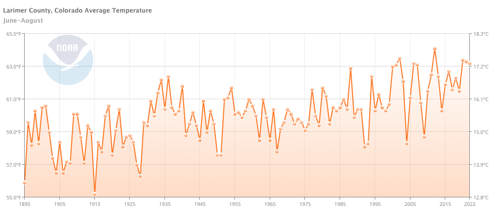
The summers of 2021 and 2022 have been quite warm in Larimer County, where about half of Colorado's glaciers reside. The county saw temperature increases of more than 2 to 2.3 degrees Fahrenheit over the mean temperature between 1980 and 2010, which is 60.9 degrees, McGrath said.
"These warm temperatures are going to drive increased amounts of melt on these glaciers and likely contributed in a significant way to the conditions that we're seeing here at the end of the summer," McGrath said.
To monitor accumulation and ablation — or new snowfall and melting — experts use repeat photography and aerial and satellite imagery photo analysis that shows shrinkage in both area and shape. Digital elevation models, also called DEMs, allow scientists to compare ice volume changes over time on a regional scale, according to the USGS.
"We have a wide range of satellites out that give us these unbelievable products that allow us to both look — kind of like optical imagers that give us pictures of glaciers, but also satellites that give us radar data to tell us how fast they're flowing," McGrath said.
Through the NSIDC in Boulder, Raup studies optical imagery of glaciers, which relies heavily on satellite photographs. He has worked at the NSIDC for more than 20 years, specializing in scouring over data from the cryosphere, which includes all the places on Earth that are frozen.
"By looking at different pictures taken from satellites, over time, we can see how ice on land is changing over time — growing or shrinking, or well, shrinking, basically," he said.
The main project he has been involved in for many years is Global Land Ice Measurements from Space, or GLIMS.
"We have a network of collaborators around the world who study images of glaciers in their regions of expertise and create outlines — basically digital maps — of the extent of glaciers at different times," Raup explained. "They send all that data to us. And I've written software to manage that and put it into a database, which is then served on the web. So, we have a nice map application that you can... It's kind of like Google Maps, but it has a layer of glacier information on it."
His colleagues work with their own software to model what might happen based on current data paired with weather forecasts and expected climate changes, he said.
Raup said he also uses altimetry — measuring the altitude of a surface. One way to do this is to shoot a low-power laser beam from space to reflect off the surface of an ice sheet or glacier and then measure the time for it to return to the satellite. Based on that data, the researchers can measure the height of the surface.
"And so people are actually measuring how fast glaciers are thinning over time," he said.
Other kinds of satellites can measure gravity, he added, by measuring the mass of something as it changes. This is a common practice when studying glaciers in Alaska, he said.
Field work is just as crucial as faraway imagery, though it comes with the cost of slogging with gear several miles uphill and working in sometimes grueling conditions.


"From a long-term perspective, we'll install weather stations, or autonomous stations that are measuring things like air temperature and snow depth on stations, or on glaciers, or near glaciers, to give us this kind of climate record," McGrath said. "To actually observe the glaciers in the field, we'll use different tools, like ground-penetrating radar."
That radar, though sometimes tricky to perfect, can detail the thickness of a glacier and therefore its elevation, which can then be monitored as it changes over time. It's a much more useful metric to monitor them compared to photography, McGrath said.
Add this to the data collected from satellites and aircrafts, and it paints a much fuller picture — in some cases, a 3D model — of the glacier's health and their flows.
Beyond this technology, the landscape tells a history of its own.
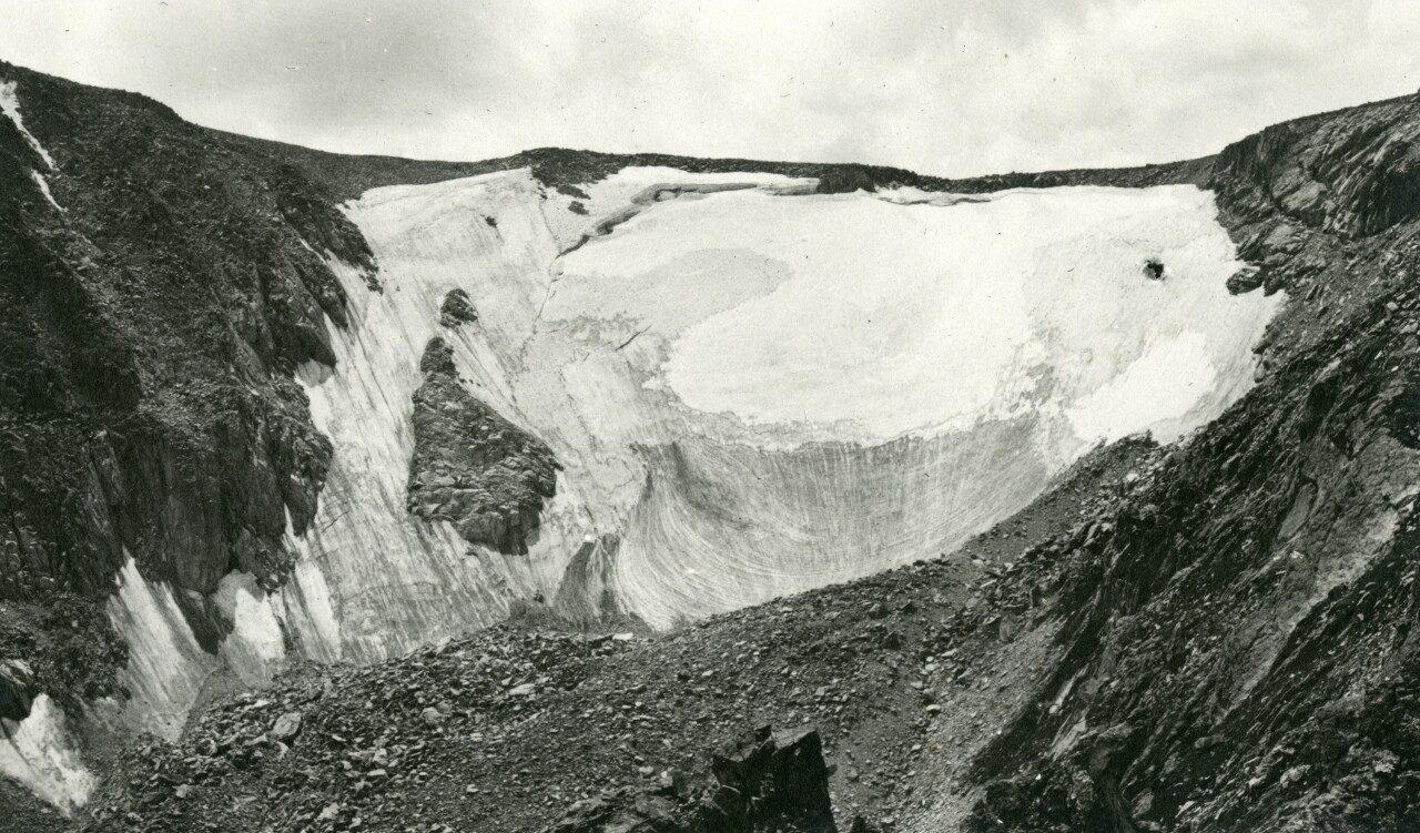
As recently as the late 1700s and early 1800s, Colorado's glaciers were much larger. During a period of cooling, called the Little Ice Age, moraines formed downstream of the glaciers. Perhaps some of the most well-known moraines in Colorado are Moraine Park and Glacier Basin in Rocky Mountain National Park.

McGrath called it a "beautiful example" of how large Colorado's glaciers were hundreds and thousands of years ago.
"We can go and very precisely say how big that glacier was at that time because it left behind this beautiful record," he said. "The glaciers today are much smaller versions of those glaciers that were here in the past."
Scientists know that thousands of years ago, Colorado's glaciers carved up a landscape that many outdoor enthusiasts know today.
"Many of the landscapes that we kind of have come to love in Colorado — especially along the Front Range, where we have these very deeply incised valleys and sharp, kind of bedrock walls and, and horn-like features in many spots — those are all the result of glacial erosion," McGrath said.
How Colorado glaciers help model for the world
"Colorado's glaciers, like glaciers all around the world, are shrinking, almost without exception," Raup said. "And basically, they're shrinking everywhere in the world, which makes them a really good indicator of climate change and that it's not just a local phenomenon, but a global one."

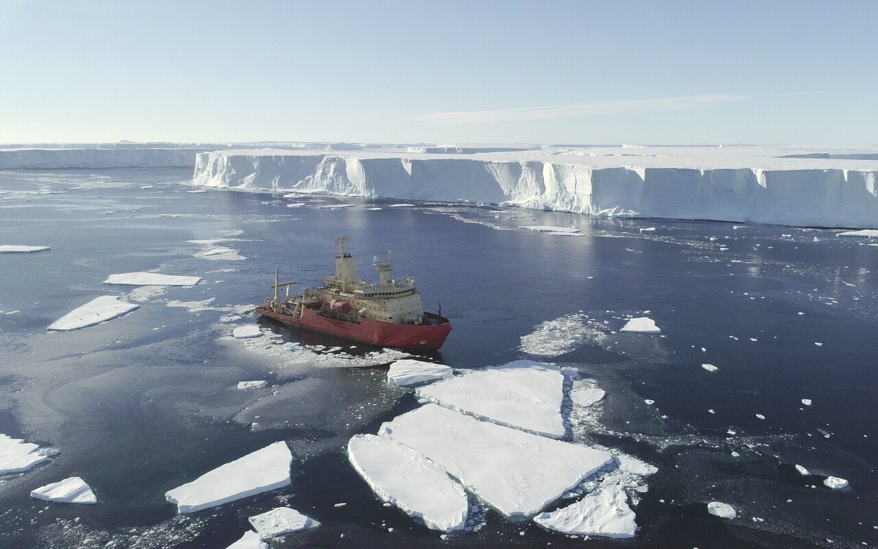
Across the world, larger glaciers do not have the natural protections available in Colorado. And while many are significantly more massive — the largest is Antarctica's Lambert Glacier, which is roughly 50 miles wide and 250 miles long — they are just as susceptible to the changes that plague their smaller cousins in the Rocky Mountains.
But blaming the melt on solely global temperatures rising is difficult, McGrath said. Researchers must isolate "what component of this natural system is due to anthropogenic climate change," he said.
"Climate change and warming air temperatures, decreasing amount of snow-water equivalent, or snow accumulation on these glaciers, are all components of climate change that we've seen in the Earth's system, and they all negatively impact glaciers," McGrath said.

While cirque glaciers behave somewhat differently than larger glaciers, they can still help predict what will play out at larger glaciers. The best place to start with that is by looking into how these cirque glaciers have ebbed and flowed.
"Another really valuable reason for studying glaciers in Colorado is they're an important analogue for other portions of the planet, what they'll look like in the future," McGrath explained. "So if we look at Alaska in 50 years, 100 years, it's going to look, you know, in many cases, like these small little glaciers that we have here in Colorado."
A study by Cambridge University on 20th century variations in glaciers within Rocky Mountain National Park found that glaciers along the Front Range were at their maximum volume in the late 1800s, retreated through the 1940s, and grew until 2000, when they began to shrink slightly again in response to warming temperatures in the summer. The paper, published in September 2017, said glacier recession along the Front Range "may be greater than at any other time in the historic record."
Studying how Colorado's glaciers have changed over the past centuries can give researchers a space-for time substitution — the method for studying slow ecological processes — to hypothesize what could happen to glaciers, and therefore the landscape, in other parts of the world, McGrath said.

And in short, it's not looking good.
Worldwide, a study published in the journal "Nature" found that glaciers are currently losing about 267 gigatons of ice per year.
"That number may not be particularly meaningful to most viewers, but each gigaton is a cubic kilometer of water, or equivalent to 400,000 Olympic-sized swimming pools," McGrath explained. "And so if we think about all this ice here, and then we sum that up with how much ice is being lost from Antarctica and Greenland over the recent past, every single year, we're basically filling up 285 million Olympic-sized swimming pools with meltwater from these glaciers."
In other words, that could fill about 105,415 Empower Field at Mile High stadiums per year, McGrath estimated.
This melting has contributed to rising sea levels and altered streamflows for large river basins, McGrath said.
"Right now, sea level is rising about 3.7 millimeters per year — or an inch and a half per decade," Raup said. "And some of that — about 40% of that — is due to thermal expansion of the oceans themselves. But the rest of it is about half-and-half between glaciers — mountain glaciers — and the ice sheets in Greenland and Antarctica. That amount of sea level rise is actually accelerating. So that number is expected to go from 3.7 millimeters a year to something like 60 millimeters a year by the end of the century, driven, I think, mostly by the ice sheets. But still mountain glaciers are very important for contributing to sea level rise."
The worldwide science community is particularly concerned about the Thwaites Glacier in Antarctica, which is larger than the state of Florida.
If the glacier completely collapses, it would raise global sea levels by about 25 inches, according to the International Thwaites Glacier Collaboration. In December, researchers from the University of Colorado in Boulder predicted that one section of the Thwaites Glacier, roughly a third of its total bulk, will likely only survive a few more years.

"It's sometimes known as the weak underbelly of the West Antarctic Ice Sheet," Raup said. "And that's because it's a relatively low-angle glacier, and it's grounded on land that's below sea level. And not only that, but as you go up glacier from the front, inland, the bedrock goes down. And so that means as it retreats, it'll get itself into deeper and deeper water, which it's thought could lead to catastrophic retreat of that glacier, and that would have huge impact on sea level."
The USGS reported that if all of Earth's glaciers and ice caps melted, global sea levels would rise by about 230 feet, flooding every coastal city on the planet and creating environmental refugees worldwide.
McGrath said in a paper he published in 2020 that glaciers will likely lose 25% to 48% of volume between 2010 and 2100, but these predictions are worse for the western United States, where this loss may increase to exceed 50% by 2030 and 80% by 2080.
READ MORE: Climate change answers in ice: Inside Colorado’s ice core lab
While there's a fair argument that much is at risk as Colorado's glaciers retreat, water resources is not one of them.
Raup explained that the melt from Colorado's glaciers is small compared to what the state gets from seasonal snow, and the impact on the state's water resources "is almost zero."
"It's more about human psychology and missing something that our parents used to have and things like that," he said about the glaciers in the Rocky Mountains.
It may not come as a surprise that researchers like Raup and McGrath sometimes get asked what it's like to work in a field seemingly filled with negativity.
"I really enjoy studying glaciers and understanding how they work and predicting how they're going to change in the future," McGrath said. "And, from a kind of societal perspective, it's really important work, because whether we're going to see 3 feet of sea level rise, or 6 feet of sea level rise, and is that going to be in 50 years or 100 years — those are trillion-dollar questions... I don't think too much like doom and gloom on a daily basis knowing that I'm studying dying glaciers because I see how important it is to understand how they're changing, and the timeline that they're going to change in for society."
McGrath and Raup also both encourage people to get outdoors and experience Colorado's glaciers while they're still here.
"Take the opportunity now to see these glaciers and ice patches," Raup said. "...Take the opportunity to see these, take pictures of them. And then if you go back in subsequent years, observe how they're changing."
"I don't think it's hopeless, either," he continued. "With more and more electrification of our energy systems and transportation systems, I think we still have a chance to slow the change. And we really need to get on top of reducing CO2 emissions. That's the bottom line for the world."
RELATED STORIES:
- Microplastics increasingly found in Colorado's snowpack
- Increase of pink ice on glacier causing climate change concerns
- Colorado communities worried about glacier water supplies
- Alpine glacier chunk detaches, killing at least 6 hikers
- 'Zombie ice' from Greenland will raise sea level 10 inches
- Climate change threatens glaciers, a source of tourism, power supplies and more
