


DENVER — The Denver area is expected to get heavy snow this weekend, as much as two feet in some areas of the Front Range. And despite the short-term problems that come with a large snowstorm, the real benefit will likely be in the mountains, where a lagging snowpack is in need of a spring boost.
Much of the snowpack along the Interstate 70 corridor in the High Country is at 83% of normal, with 81% of normal further south and 79% of normal in southwestern Colorado, according to the Natural Resources Conservation Service snow survey. The Denver area and foothills snowpack are at 86% of normal, so the heavy snow should help bump that up.
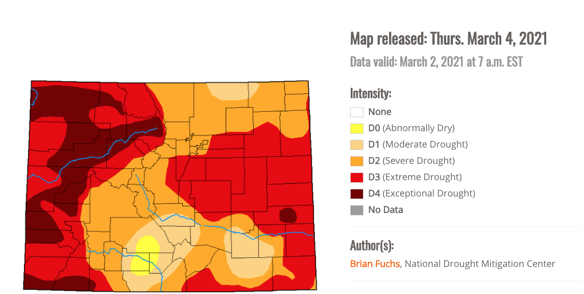
Statewide, any precipitation will help — much of the Western Slope and Eastern Plains are under extreme drought conditions, according to the U.S. Drought Monitor. Several pockets of those areas are under exceptional drought conditions, the highest drought indicator on the monitor. Only a small pocket in southern Colorado is under abnormally dry conditions, the lowest indicator on the monitor.
While Colorado's snowpack is lagging below normal, a snowstorm like we're expected to see this weekend shows how March can help the state play catch-up.
While Colorado is well behind the snowpack levels we saw in 2019, it was a snowy spring that year that boosted the snowpack to near-record highs. Going back to 2010, the snowpack level then was comparable to what it is this year, before a snowy spring bumped levels up to average.

As of Wednesday, the heaviest of the snow was forecasted for the Nederland area of Boulder County and areas to the north. But even east and west of that projected area, snowfall totals could surpass 1-2 feet.
Track the storm in real-time with our 24/7 weather stream:
