

Tonight's Forecast:
Winds will calm down for the Pikes Peak Region and other areas will follow. Temperatures will decline into the teens and 20s overnight. Alamosa will get down into the single digits again.
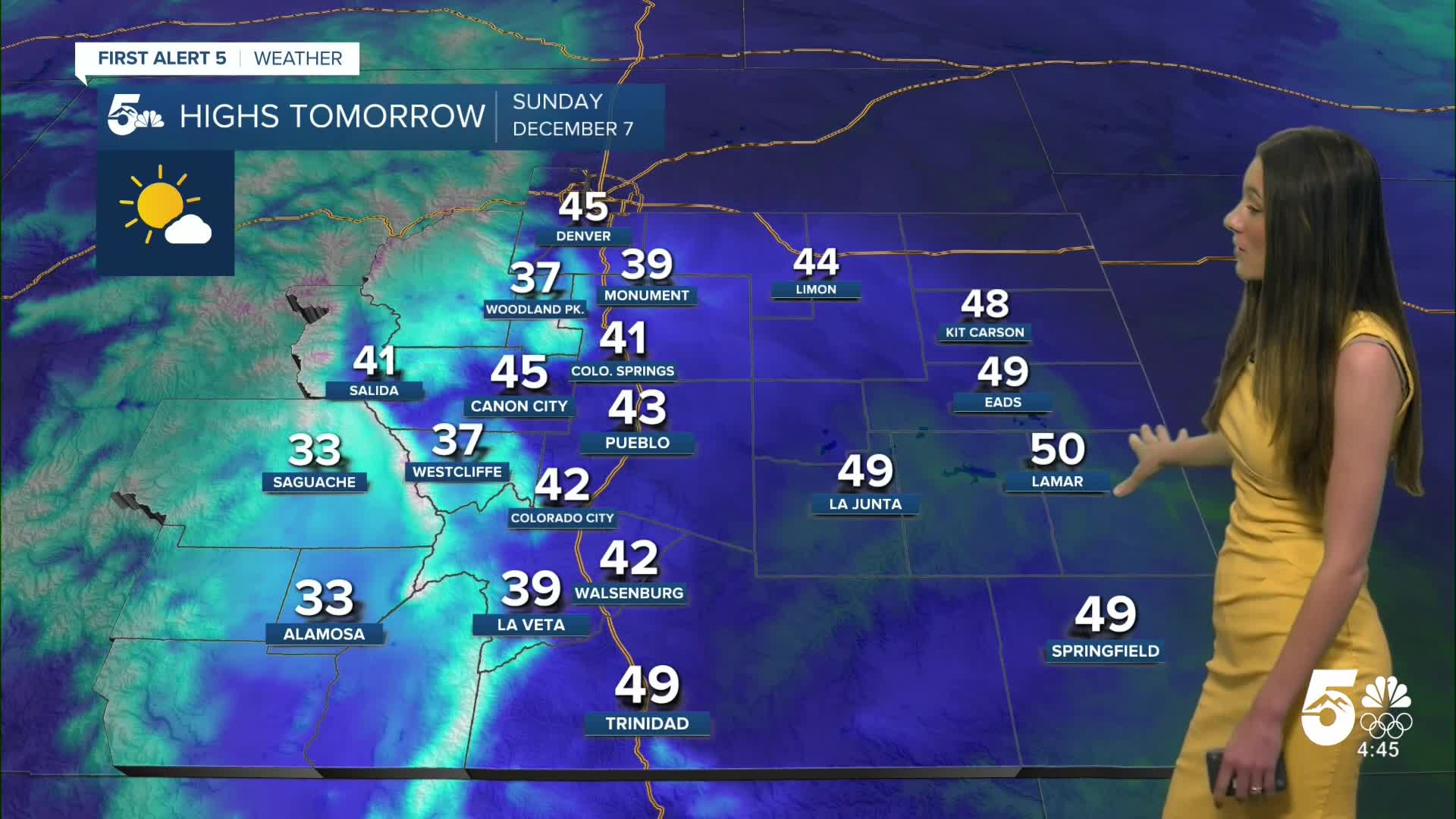
Colorado Springs forecast: Low: 21; High: 41;
Colorado Springs will be a few degrees cooler tomorrow with highs only making it into the lower 40s. Winds will be much calmer and there will be more sunshine throughout the day.
Pueblo forecast: Low: 21; High: 43;
Pueblo will start the day with temperatures in the lower 20s. By the afternoon, highs will have reached the lower 40s. Winds will be between 5 and 10mph with winds eventually coming out of the southeast.
Canon City forecast: Low: 23; High: 45;
Canon City will start off chilly with temperatures in the lower 20s. By the afternoon, temperatures will warm into the mid-40s. Winds will be much calmer between 5 and 10mph.
Woodland Park forecast: Low: 25; High: 37;
Woodland Park will dip into the mid-20s overnight, and winds will gradually calm down. Clouds will move out of the area and make way for some sunshine by Sunday. Afternoon highs will be in the upper 30s.
Tri-Lakes forecast: Low: 25; High: 39;
Monument will have an overnight low of 25 degrees. The morning will continue to have chilly temperatures. Afternoon temperatures will still be cold, only making it into the upper 30s. Any outdoor plans will requite multiple layers.
Plains forecast: Low: 25; High: 40s & 50s;
The plains will have winds calm down overnight and any precipitation will also move out of the area. Afternoon highs will get into the 40s and 50s with plenty of sunshine.
Walsenburg and Trinidad forecast: Low: 25; High: 42/49;
The southern I-25 corridor will have temperatures tomorrow morning in the mid-20s. The afternoon will warm into the 40s. Winds will be noticeably calmer between 5 and 10mph.
Mountains forecast: Low: 25; High: 30s;
The mountains will have snow showers lighten overnight and by Sunday morning only clouds will remain. By the afternoon, there will be bright and sunny skies across the area. Temperatures will be in the 30s by the afternoon.
There is a heightened concern for some avalanche danger in the mountains. North of Steamboat Springs will have a high (4 out of 5) risk for avalanches. Even Pikes Peak and surrounding mountains have a moderate risk (2 out of 5).
Extended outlook forecast:
The start of the work week will look very similar to Sunday. Highs will remain in the 40s, but temperatures will warm up by Wednesday. Winds will also pick up by the middle of the week.
____
Curious about the First Alert 5 Weather Storm Impact Scale? Check out our cheatsheet explainer.
Watch KOAA News5 on your time, anytime with our free streaming app available for your Roku, FireTV, AppleTV and Android TV. Just search KOAA News5, download and start watching.
