

Today’s Forecast:
The weather pattern gets a lot more active over the next 48 hours with gusty winds and high fire danger today followed by very cold air tomorrow!
Red Flag Warnings are in effect along I-25 and west into the mountains and valleys from the late morning through the end of the day. Wind gusts will be between 30 to 45 mph, and we'll see relative humidity values drop into the low teens. If a fire were to catch today, it could spread quickly in these conditions.
A strong cold front will move across the plains tonight just after midnight. This front will bring gusty winds and very cold air. High temperatures on Wednesday are set to be in the 40s and 30s across the plains with temperatures Thursday morning in the teens.
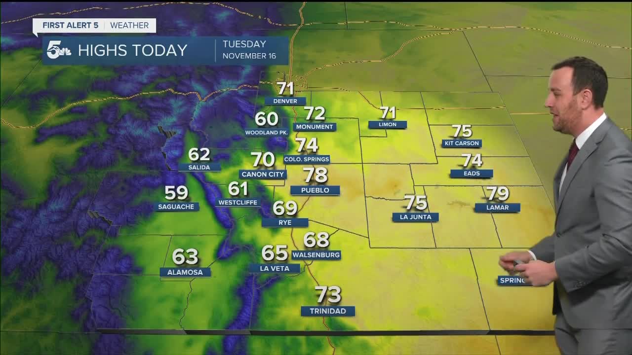
COLORADO SPRINGS: High: 74; Low: 29. Mostly cloudy and windy today with warm daytime temperatures and high fire conditions. Wind gusts could max out in the 20 to 30 mph range on the west and north sides of town through the afternoon.
PUEBLO: High: 78; Low: 30. Mostly cloudy and windy today with warm daytime temperatures and high fire danger. Wind gusts will max out close to 30 mph through the afternoon.
CANON CITY: High: 70; Low: 33. Mostly cloudy and windy with high fire danger and warm afternoon temperatures. Daytime wind gusts will max out in the mid 30 mph range.
WOODLAND PARK: High: 60; Low: 25. Cloudy and windy today with mild temperatures and dry skies. Fire danger is high with Red Flag Warnings through the evening and wind gusts in the mid 30 mph range.
TRI-LAKES: High: 60s; Low: 20s. Cloudy, mild, and windy today with high fire conditions through the afternoon. We'll see wind gusts in the 20 to 30 mph range through the daytime with a chance for a few snowflakes and flurries Wednesday morning behind a strong cold front tonight.
PLAINS: High: 70s; Low: 30s. Windy to breezy today with elevated fire danger across the plains. We'll see the highest fire danger in the I-25 corridor, where the wind gusts will be highest and the humidity low. A cold front will push south across the plains after midnight with gusty winds and very cold temperatures.
WALSENBURG/TRINIDAD: High: 60s; Low: 20s. Windy and warm today with very high fire danger across the southern I-25 corridor. We'll see wind gusts in the 30 mph range, especially near Walsenburg and west through La Veta Pass.
MOUNTAINS: High: 60s; Low: 20s. Very windy across the mountains and valleys today with widespread high fire danger. We'll see valley and mountain gusts in the 30 to 40 mph range with dry skies and low humidity.
Extended Outlook:
A strong cold front will move south across the mountains and plains tonight with highs set to drop into the 40s along & east of I-25 for Wednesday. We could see a few flurries in the morning along the Palmer Divide, but most of our region will be dry.
Temperatures will start in the teens Thursday morning, but we should warm into the 40s through the afternoon. We will stay dry through Friday with highs in the 60s across the plains.
KOAA News5 on your time, streaming on your Roku, FireTV, AppleTV and AndroidTV.
