


Today’s Forecast:
We're in for a very active day here in southern Colorado due to very strong winds, widespread fire danger, and even a chance for rain and snow in the northern part of our viewing area!
Winds:

The two top stories for our region today are high winds and fire danger.
We could see extremely strong daytime wind gusts in the 40 to 60 mph range, with top wind gusts hitting 65 mph in a few areas. The strongest gusts will be over the mountain passes, in the valley towns like Alamosa, and out along the Highway 50 corridor from Canon City through Pueblo and out to La Junta.
Wind restrictions for semi-truck drivers will be possible from Colorado City all the way down through Walsenburg and Trinidad for very strong westerly winds.
Fire Danger:
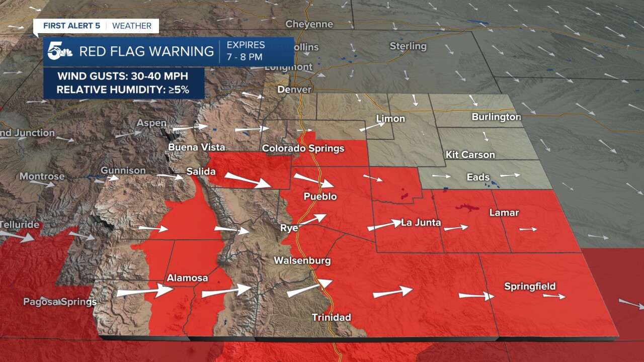
Fire danger was high Monday, but it's even higher and more widespread today.
Strong winds and very dry air running out of the mountains and valleys into the plains will provide fuel to dry grassy areas for fires today. Any spark that ignites could spread quickly and easily.
Absolutely no burning today, make sure chains on trailers do not drag, and be sure to call in any smoke you see across the region.
Rain & snow chance:
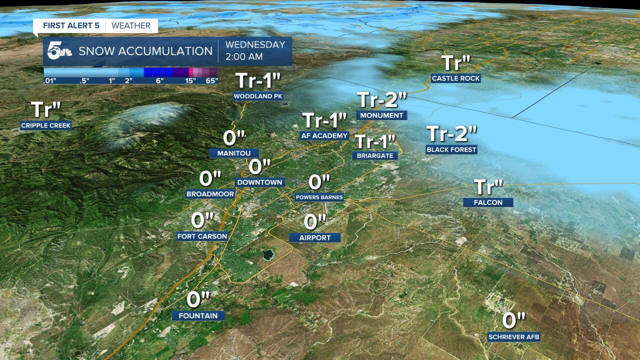
On top of high fire danger and strong winds, we could actually see rain and snow across northern El Paso county tonight!
Most of the region will see scattered rain showers behind our cold front, mainly in El Paso county and east across the plains north of Highway 50.
We should get cold enough to turn some rain to snow in the region, but mainly along the Palmer Divide and at elevations over 6,500 feet. Wave pavement would keep most snow accumulation to grassy areas and cars overnight.
COLORADO SPRINGS: High: 66; Low: 32. Very windy all day today with a chance for rain and snow showers from northern to central Colorado Springs this evening. Snow showers could fall over all of the city if we get cold enough tonight, but the actual accumulation in the grass would stay mostly on the far north end of town.
PUEBLO: High: 74; Low: 33. Warm and dry with extremely strong wind gust potential this afternoon and evening. Gusts could hit 60 mph later today, and we should stay dry tonight.
CANON CITY: High: 65; Low: 36. Warm and very dry with strong daytime winds in the afternoon. Gusts could hit 60 mph at their strongest today, and we should stay dry tonight.
WOODLAND PARK: High: 49; Low: 25. Chilly and windy today with increasing daytime cloud cover. We could see a passing evening snow shower will little to no accumulation expected.
TRI-LAKES: High: 50s; Low: 20s. Chilly and windy with gusts in the 30 to 40 mph range through the afternoon and evening. A cold front will pass at the end of the day, and we'll have rain quickly turn to snow in the evening. Snow accumulations are possible this evening and we could see a quick inch, maybe a touch more in a few isolated spots but mostly in grassy areas.
PLAINS: High: 70s; Low: 30s. Extremely strong daytime winds and very high fire danger today. The winds will gust along the Highway 50 corridor in the 60 mph range this afternoon. We could see rain showers blow through this evening, mainly for areas north of Highway 50 and east of El Paso county. Fire danger along Highway 50 in the grassy areas is very high today.
WALSENBURG/TRINIDAD: High: 60s; Low: 30s. Very windy and dry today with high fire danger well into the evening. We'll be warm ahead of our cold front tonight and we should stay dry. Wind gusts out of the west could be in the 50 to 60 mph range, so we could see wind restrictions for semi-truck drivers along I-25 from Colorado City through Trinidad.
MOUNTAINS: High: 50/60s; Low: 30s. We'll see elevated fire danger over the mountains today, but mainly for the dry grassy areas down the slopes. The winds will be very strong and gusty today in the Wets and Sangres with 40 to 50 mph gusts through the afternoon, but the mountain passes could be even higher. We should stay dry tonight other than snow showers over the Rampart Range in El Paso county.
Extended Outlook:
Wednesday will be dry and chilly with more wind through the afternoon. We'll stay dry over the weekend for most of the region, but pretty much every day will remain windy.
KOAA News5 on your time, streaming on your Roku, FireTV, AppleTV and AndroidTV.
News5 App | First Alert 5 Weather App | Youtube | Facebook | Instagram | Twitter
