


A winter storm will move into southern Colorado overnight Tuesday and into Wednesday morning. Conditions will deteriorate by early Wednesday morning, potentially making travel difficult.
- A look at how the cities of Colorado Springs and Pueblo have been preparing
First Alert 5 Forecast 10 PM Update
A look at conditions in the Pikes Peak region:
First Alert 5 Forecast 6 PM Update
A look at conditions in El Paso County:
Help Us Tell The Story
What's the weather like in your area? Share your photos and videos with us, and we will share them online and on-air!
Road Closures
Today's Forecast:
The storm is here and starting at 8 am, the Colorado Springs and Pueblo metro areas will be under a Winter Weather Advisory. In Monument and Woodland Park, these advisories began at 2 am. All areas will see the advisories continue until 8 pm. Bands of heavy snow will increase throughout the morning hours, leading to periods of heavier snow. I think that the heaviest snow will pick up after 9-11 am in the Pikes Peak Region and Pueblo County. This is likely to lead to variable totals not just in these areas, but across Southern Colorado.
Snow totals in the Springs are likely to range between 3-8", with the highest amounts on the north and west sides of town. As the storm ramps up, wet roads are likely to turn snowy, with the morning commute from the Springs to Denver far worse than areas south of Highway 50. By this evening, snow will wrap up, but some roads will remain snow covered. There's also a concern for ice to develop tonight, especially on bridges and overpasses. Your Thursday morning commute is likely to be impacted.
Wednesday 3:00PM Update:
Current radar is showing snow still falling over much of southern Colorado. Over the next few hours the snow will gradually become lighter. This means visibility will also improve. Roads, however, will still be an issue. With temperatures dropping, roads will turn from slushy to icy. Budget enough time to get to your destination. There will still be some accumulations over the next few hours as well. Stay safe!
Wednesday 1:00 PM Update:
Visibility continues to be a concern with some areas down to 1/3 mile. Moderate to heavy snowfall will continue into late this afternoon. The southern I-25 corridor is starting to see some heavier bands of snow move in. Expect roads to remain an issue into the evening.
Wednesday 11:15 AM Update:
Winter Storm Warnings have been expanded across parts of the San Luis Valley and the Eastern San Juan mountains, where heavy snow banding is likely to continue into this evening. Here's a look at the latest Winter Weather Alerts map:

Wednesday 10:30 AM Update:
After some healthy morning commute snow bands moved through the Pikes Peak Region, current surface analysis (e.g. current conditions maps) show wind direction is largely north in the Pikes Peak Region, with only a small easterly element. The more east the wind, the better the mountains help to fling the air up and generate snow. The more the winds come from the north, the more the air tends to move downhill and reduce snow rates. That's leading to lower snow rates at the 10 AM hour in the Pikes Peak Region, with bands of heavier snow over the south Pueblo area, up into Beulah and the Wet Mountains, and southwest to Walsenburg.
In these areas, winds are cranking in out of the east, providing great moisture as a cold front continues to push its way westward. At the same time, upper level energy continues to stream over I-25. If you're looking at radar, this combination of the easterly front plus the energy from the west - is why you see the snow bands moving in two different directions across southern Colorado.
Parts of the Wet Mountains are seeing rates above 1"/hr with the blend of upslope flow, upper energy, and mountain enhancement. Across the broader I-25 area snow rates are a bit lighter at the moment - about .25"/hr.
Wednesday 7:00 AM Update:
Snow is continuing to fill in across southern Colorado. At the moment, the heaviest snow is across Pueblo county with a band of estimated 0.7-0.9"/hr rates extending from approximately Pueblo West to Boone. Slightly lighter rates of 0.2-0.5"/hr are falling along I-25 between the Palmer Divide and Fountain. So far, upslope flow remains modest. As flow increases through the AM hours, banding will become more well established due to orographic (mountain) snow enhancement.
Roads are wet below about 6500 feet, and snow covered above that height. I-25 at Monument Hill has a light layer of slush, while surrounding side roads have a coating to an inch of accumulation. Grassy surfaces are closer to 3" of accumulation.
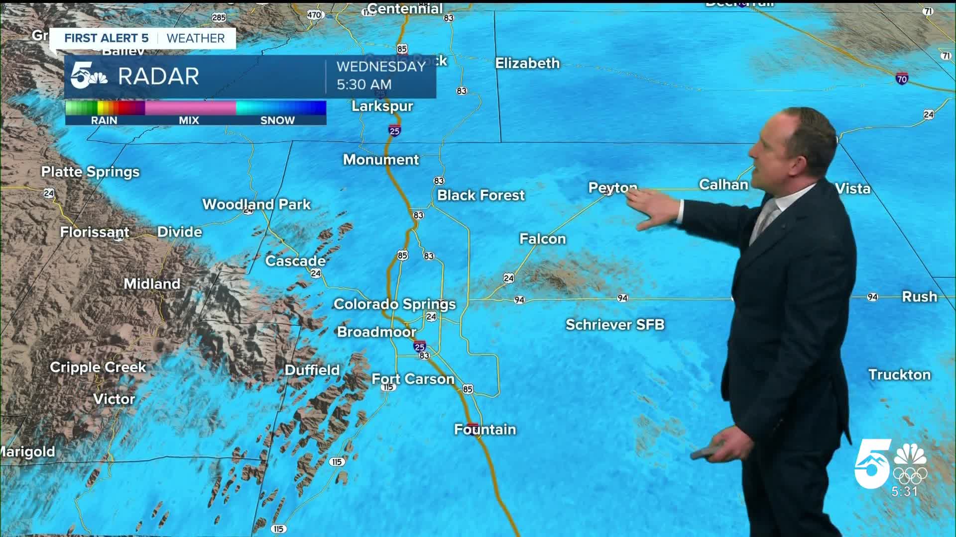
Wednesday 6:00 AM Update:
Roads, while clear, remain wet early Wednesday morning. Conditions are expected to deteriorate as the Wednesday morning commute continues, as heavier bands of snow are expected to make their way across the Pikes Peak Region as the day moves on. Watch below for a look at what conditions along Monument Hill looked like around 5 a.m.
Tuesday 5:30 PM Update:
Winter Weather Advisories are in place for all of I-25 through Wednesday evening. Thursday morning will still have icy conditions for the early morning commute.

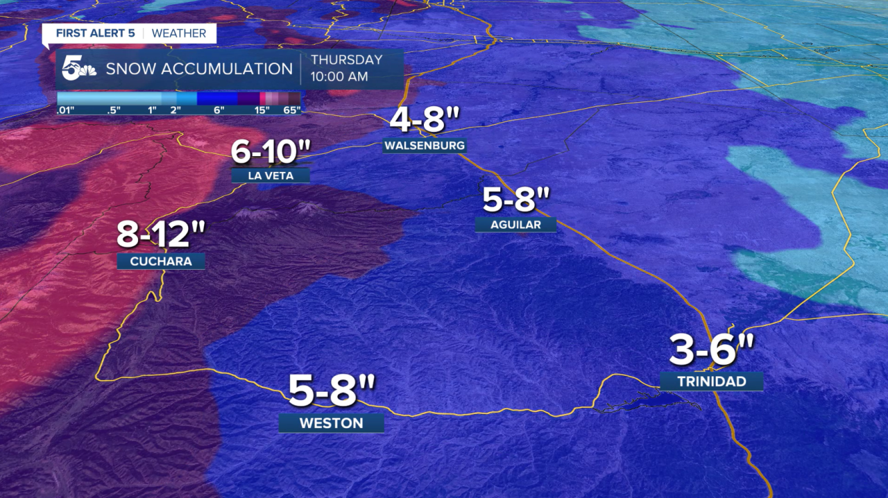
Snowfall Accumulations:
The highest snow totals will be for the mountains and higher elevations. Expect a couple of inches of snowfall for the I-25 corridor. This will create hazardous driving conditions through Thursday morning.


Timing:
Wednesday morning, expect harsh conditions to occur between Colorado Springs and Denver. Snow will be accumulating on roads in Colorado Springs. Budget extra time to get to your destination, and for back roads to not be plowed right away. Pueblo will start to see impacts later in the day.
By Wednesday afternoon, snow will still be falling across all of southern Colorado. This is also when the highest impacts will be moving in. Expect snowy roadways and icy, cold conditions.
Thursday morning snow will lighten, but roads will remain icy. With temperatures well below freezing it will still impact Thursday's commute. Some roads will be plowed by then, but still budget in extra time to get to your destination.
Track this storm through the morning, including snow totals and updated forecasts, on the First Alert 5 Weather stream, which can be viewed on the KOAA News5 app for your Roku, FireTV, AppleTV or AndroidTV.
Resources:
- Get your latest First Alert 5 Weather Forecast
- Find the current school closing and delay list
- Keep track of flight delays at Denver International Airport or the Colorado Springs Airport
- Watch KOAA News5 LIVE newscasts and updated content throughout the day in your browser, the News5 App, or your favorite streaming device.
- Download the free News5 App for your iOS or Android device to get the latest headlines and news across Colorado.
- Download the free First Alert 5 Weather App for your iOS or Android device to get the latest headlines and news across Colorado.
- You can find us on social media with KOAA on YouTube, Facebook, Instagram, Twitter, and BlueSky.