

SOUTHERN COLORADO (KOAA) — The News5 and the First Alert 5 Weather Team will keep you updated on the impacts. We'll update this blog as necessary.
The snow might slow some community members down, but it doesn't completely freeze their plans.
This snowstorm is expected to boost our snowpack amid an unseasonably warm start to winter.
Road Impacts
Expect significant impacts to your commute on Friday, and if you must drive, take it slow.
- Per CDOT: I-25 southbound: Right shoulder closed due to a crash. At Exit 96: Minnequa Avenue (Pueblo) at Mile Point 96.
- PerCDOT: I-25 southbound: Right lane closed for a crash. Between Exit 97A: Central Avenue to Northern Avenue and Exit 96: Minnequa Avenue (Pueblo) at Mile Point 96.5.
- Per CDOT: CO 47 southbound: Crash. Between Baculite Mesa and Dillon Drive (Pueblo) at Mile Point 1.8
- Per CDOT: I-25 northbound: Two left lanes closed for a crash. Between Exit 116: County Line Road and Exit 119: Rancho Colorado Boulevard (8 miles north of Pueblo West) at Mile Point 116.
- Per CDOT: CO 10 westbound: Crash. At County Road 2 (27 miles west of La Junta) at Mile Point 44.
- Per CDOT: US 24 eastbound: Crash. Between Rampart Terr Road and Hagerman Avenue (Cascade-Chipita Park) at Mile Point 293.
- Per CDOT: CO 167 northbound: Crash. Between County Road B5 and County Road LL5 (near Fowler) at Mile Point 1.
Friday, January 9th
10:00 AM Forecast Update:
A snow band that briefly set up over western Colorado Springs over the past hour is dissipating as northerly winds bring in drier air. As wind gusts increase, blowing snow will become an increasing concern through the early afternoon hours resulting in visibility reductions. Overall, roads in the Pikes Peak Region will remain icy, slushy, and snow covered for the next several hours and visibility will be low.
La Junta and the lower Arkansas River Valley are in the main band of heavier snow currently, with strong convergence (winds moving the air together) leading to several more inches of accumulation in the southeastern plains.
7:30 AM Forecast Update:
Northerly flow has been increasing across the Pikes Peak Region this morning as low pressure moves through New Mexico. This has successfully stopped the heavier snow from falling in the Colorado Springs metro area since about 5 am.
For the remainder of the morning hours, snow will wrap up from north to south, with a few flurries still possible in Colorado Springs until around 8 a.m.
Along the I-25 corridor, the snow is expected to push south of Highway 50 by the lunch hour. Farther east and south of Highway 50, snow will continue to pile up well into the afternoon hours.
The highest totals for the remainder of the day are expected in the southeastern Plains. Some areas south of Highway 50 could still see an additional 5-10" of accumulation.
The snow is being cut off by the departing low and the increasing northerly flow. This works as a snow eater for areas south of the Palmer Divide. As the northerly flow picks up, it will get quite gusty, with peak gusts today around 30-40 mph.
Temperatures will remain cold, only warming into the 20s and 30s on the Plains. Wind chill temperatures in the Springs today are likely to remain below 20 degrees.

6:00 AM: The City of Colorado Springs says plows are on a full call out and are currently working to clear the primary routes ahead of the Friday morning rush hour. Crews are reporting that roads remain slick across Colorado Springs. Take it slow.
City snow plows are on a full callout addressing primary routes. Roads are snow covered and slick throughout the city. If you must travel be prepared for winter conditions, take it slow and be safe everyone! https://t.co/zetLBqMda1
— City of Colorado Springs (@CityofCOS) January 9, 2026
Our crew is at the Colorado Springs Airport, and reports wind is increasing and the airport road entrance has snow.
Meteorologist Casey Dorn observed crews actively clearing off the main runway at the top of the hour with light blowing snow. The Colorado Springs Airport is currently reporting 4 cancellations and 1 delay.
5:00 AM: Our crews out on the road are saying be prepared for some icy patches under the snow that could cause some headaches on your morning commute. Plan for some extra time this morning if you have to make it in from work. Hear from News5's Casey Dorn in the video player below regarding the conditions Friday morning.
4:30 AM: Snow has accumulated overnight, and waking up Friday in Southern Colorado, it is a winter wonderland. At the Colorado Springs Airport, a record was set overnight as 9.4 inches of snow have fallen so far.
Record breaking snowfall was reported on Thusday at the Colorado Springs Airport, and more has fallen since midnight!
— Alan Rose (@AlanRoseWX) January 9, 2026
Some parts of town are reporting as much as a foot of snow from the storm. #cowx pic.twitter.com/zmWiTPgqqq
Thursday, January 8th
10:00 PM: Snow was accumulating on the grass and on buildings, but I-25 just stayed wet for the most part for most of Thursday. But when the sun went down, that changed pretty quickly.
6:00 PM: View the video below to see how road conditions are near the United States Air Force Academy:
Checking in on the weather in Pueblo. Some may not want snow, but one specific group of people will take it.
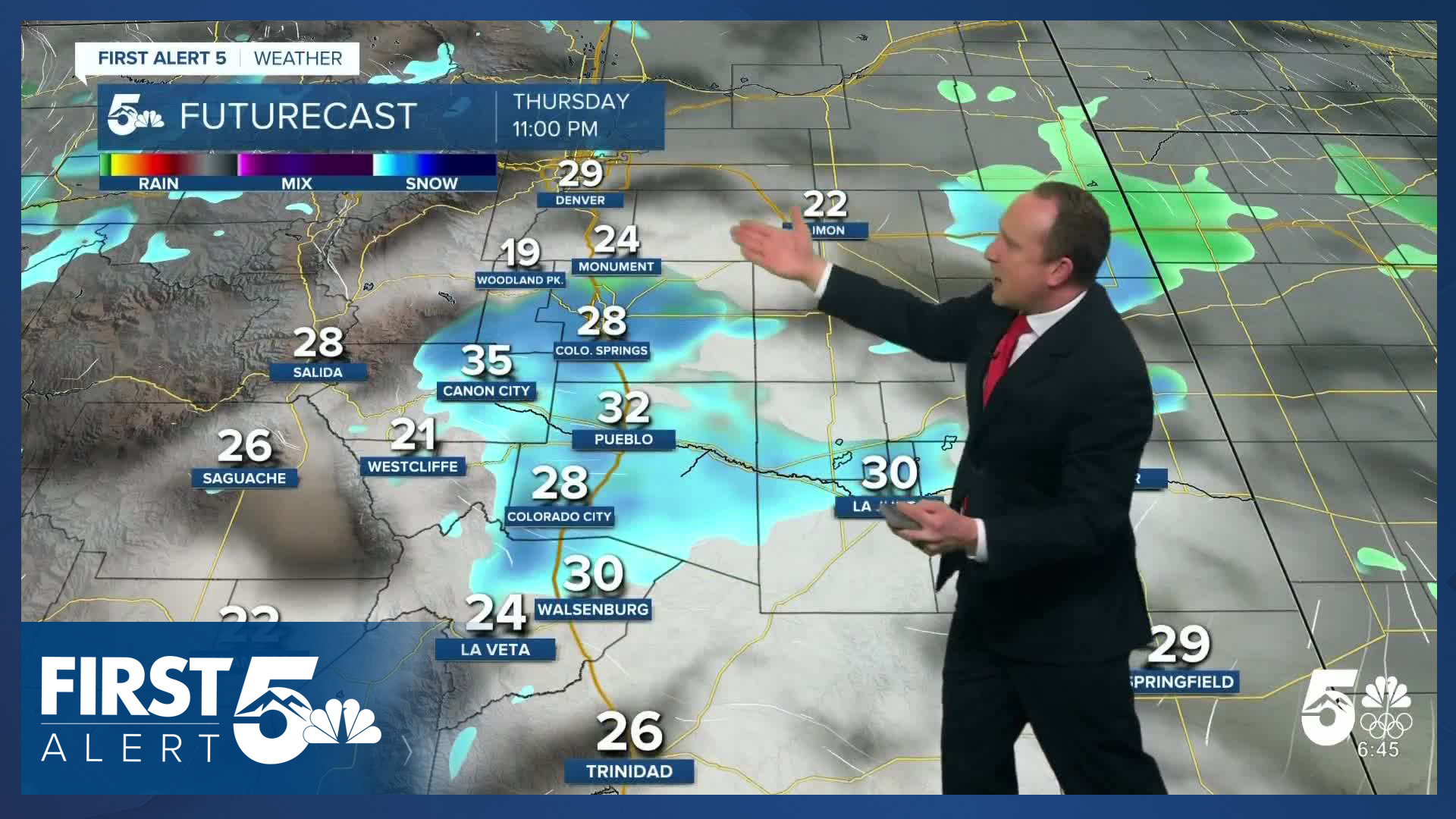
12:00 PM: Winter Storm Warnings and Watches are in effect for the higher terrain and the I-25 corridor through Friday. Heavy snowfall combined with gusty winds will reduce visibility and make traveling difficult. Hazardous conditions will likely impact morning and evening commutes.
Timing:
Snow will begin in the higher terrain and into El Paso county during the afternoon hours on Thursday. Snow will ramp up and become heavy at times, especially during the evening commute.
Snow showers will push south into Pueblo county and will also become heavy. With gusty winds, this may reduce visibility at times.
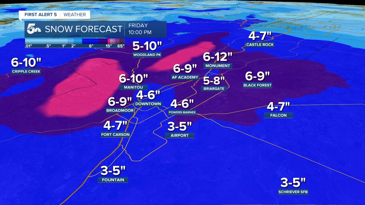
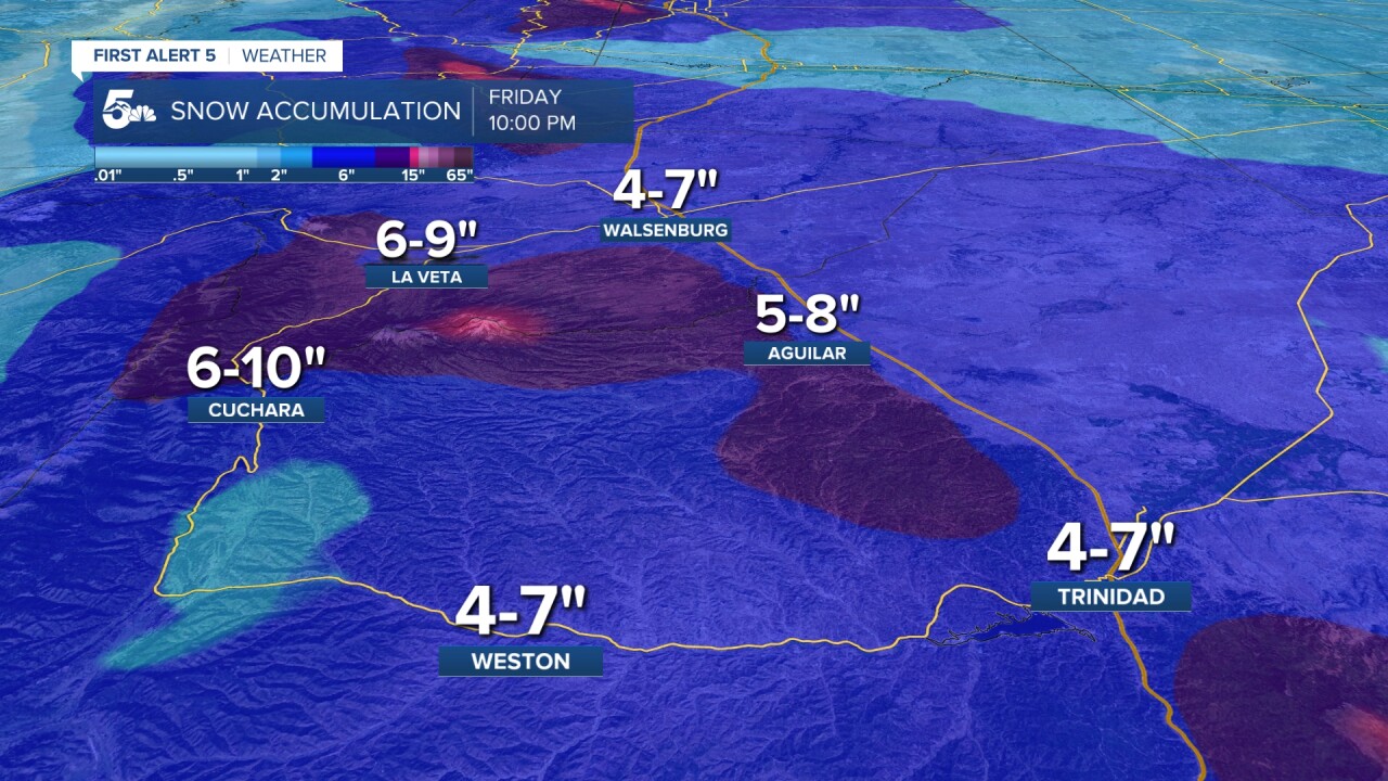
Accumulations:
Snow accumulations will be much higher with this system, especially towards the mountains and higher terrain. Here's a look at forecast totals:

Help Us Tell The Story
What's the weather like in your area? Share your photos and videos with us, and we will share them online and on-air!

School Closings and Delays
Track this storm through the morning, including snow totals and updated forecasts, on the First Alert 5 Weather stream, which can be viewed on the KOAA News5 app for your Roku, FireTV, AppleTV or AndroidTV.
Resources:
- Get your latest First Alert 5 Weather Forecast
- Find the current school closing and delay list
- Keep track of flight delays at Denver International Airport or the Colorado Springs Airport
- Watch KOAA News5 LIVE newscasts and updated content throughout the day in your browser, the News5 App, or your favorite streaming device.
- Download the free News5 App for your iOS or Android device to get the latest headlines and news across Colorado.
- Download the free First Alert 5 Weather App for your iOS or Android device to get the latest headlines and news across Colorado.
- You can find us on social media with KOAA on YouTube, Facebook, Instagram, Twitter, and BlueSky.