


Today’s Forecast:
Snow will be moving in from Denver this morning and spread south across the region through the afternoon and evening.
Denver commuters this morning should be prepared for a slow drive with low visibility and deteriorating road conditions after 7 am. The Denver metro will see snow accumulations generally between 3 to 5 inches through the afternoon, so the roads could still very well be slick through the afternoon and evening commute back home.
Snow will start falling in northern El Paso County by 7 am and spread south into Pueblo by 11 am to noon. Northerly winds will make it so very little accumulation stacks up in El Paso, Pueblo, and eastern Fremont counties today, but blowing snow could still lower visibility when you're out driving.
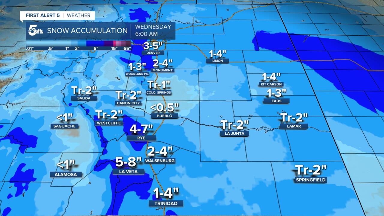
The heaviest snow will collect through the afternoon and evening over the Wet mountains and southern Sangre De Cristos in areas like La Veta and Cuchara. Walsenburg to Trinidad will see moderate accumulations through the evening, meaning any commutes home from work could be snowy and slick.
Temperatures will be steady or falling through the afternoon with most areas in the 30s or colder through the afternoon.
COLORADO SPRINGS: High: 30; Low: 12. Snow will start to fall in northern El Paso County by Monument Hill and Black Forest as soon as 6 to 7 am today, only to spread south through the morning and afternoon. We should see the heaviest snow across El Paso County between 10 am to 3 pm today, but north winds will really limit accumulations. Snow totals on the north end of town could be up to 2 inches, but south of Briargate we're likely seeing an inch or less. Manitou Springs could range between 1 to 2 inches today if we get a little more of an easterly daytime wind. We'll dry out tonight with lows falling into the low teens by Wednesday morning.
PUEBLO: High: 35; Low: 11. Snow showers will move into Pueblo by the early lunch hours and continue to fall through the early evening. Unfortunately for PUeblo, north winds will really limit snow accumulations. Despite what could be sporadic heavy bands of snow, we're forecasting an inch or less through the city of Pueblo and the surrounding towns.
CANON CITY: High: 37; Low: 15. Snow showers will move into the Canon City area by the early lunch hours and continue to fall through the early evening. Northerly winds will really limit snow accumulations through eastern Fremont County, with a dusting to 2 inches expected through Canon City, Penrose, and Florence. Heavier snow amounts are expected south of the area up into the Wet Mountains.
WOODLAND PARK: High: 25; Low: 8. Snow showers will move in this morning and continue through the afternoon. Northerly flow will limit snow accumulation in Teller County today, but we could still see roughly 1 to 3 inches from Woodland Park to Cripple Creek and west out to Divide. Snowier commutes north along Highway 67 are expected the closer you get to Denver. We should be dry tonight but very cold with lows in the single digits.
TRI-LAKES: High: 20s; Low: >10. Snow will move down from Denver by 6 to 7 am this morning with more intense snow from the mid-morning through the early afternoon. The morning commute will be rough the closer you get to Denver today, but after 8 am, road conditions along I-25 from Denver through Monument Hill should deteriorate quickly. Snow totals over Monument Hill and Black Forest should range from 2 to 4 inches with higher snow totals on the north side of the hill up to Castle Rock and Denver.
PLAINS: High: 40s; Low: 10s. Snow will move in from the north day with a heavy band of snow likely for areas along and north of Kiowa counties. Areas along and north of Highway 50 could see a dusting to 3 inches generally, but Kiowa and Cheyenne Counties could see between 3 to 4 inches. Areas along and south of Highway 50 overnight could see snow generally between a dusting and 2 inches
WALSENBURG/TRINIDAD: High: 30s; Low: 10s. Windy and cold today with snow from the afternoon through the overnight hours. The heaviest snow will fall from the end of the day through the overnight hours with Walsenburg likely to grab an inch or two more than Trinidad. The evening commute will be problematic along I-25 due to blowing snow and deteriorating road conditions. Heavier snow is expected out west over areas like La Veta Pass.
MOUNTAINS: High: 20s; Low: >10. Snow will start around the lunch hour over the Wet Mountains and spread south through the overnight hours. The Wet Mountains and southern Sangres through La Veta and Cuchara could easily see snow accumulations of at least 4 inches but up to 8 inches in some spots. The Front Range up by Teller county will start seeing snow by the morning commute but snow totals in areas like Ute Pass should stay between 1 to 3 inches.
Extended Outlook:
Wednesday will start dry but COLD in southern Colorado with lows in the teens and a few single digits. The pavement could still be slick and snowy from Tuesday night snow, especially south of Pueblo in the mountains and across the plains.
A second cold front will hit early Thursday morning with weak snow showers and flurries to follow through the afternoon. Temperatures will likely only warm to the 30s on Thursday afternoon.
Friday looks warmer and dry with a warming trend through the weekend.
____
Watch KOAA News5 on your time, anytime with our free streaming app available for your Roku, FireTV, AppleTV and Android TV. Just search KOAA News5, download and start watching.
