


Today’s Forecast:
A long-duration, high-impact snow winter storm is headed to Colorado from tonight through early Thursday morning.
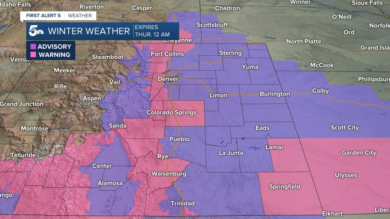
Winter Storm Warnings and Winter Weather Advisories are in effect from late today through midnight Thursday morning.
Today will start chilly and dry with increasing clouds and breezy daytime conditions. Snow will start up north in the mountains and near Denver by 3 to 5 pm, moving into the Pikes Peak Region between 4 to 6 pm.
Snow will spread south and east overnight, picking up intensity through Wednesday morning. Snow will fall near-continuously Wednesday, ending after midnight Thursday morning.
Travel will be dangerous and not advised tonight through most of the day Wednesday along the interstate, west into the mountains, and east across the plains.
Temperatures will fall into the teens and single digits tonight and stay in the teens through the entire day Wednesday.
COLORADO SPRINGS: High: 36; Low: 11. Increasing cloud cover today with cold and breezy daytime conditions. We should stay during the daytime, but snow will start to show up by 6 pm tonight and continue through Wednesday night. We could be looking at 3 to 6 inches across El Paso county by tomorrow morning alone, with more expected to fall through the evening.
PUEBLO: High: 40; Low: 12. Building cloud cover through the afternoon with cold and dry conditions through the evening commute. Snow will start to fall this evening, generally anytime after 7 pm and continue through Wednesday night. We could see 1 to 3 inches through Pueblo county by Wednesday morning with more to fall through Wednesday night.
CANON CITY: High: 38; Low: 15. Increasing clouds with dry and cold conditions during the daytime today. Snow will start to fall this evening anytime after 6 to 7 pm and continue to fall through Wednesday night. We could wake up to 3 to 6 inches by Wednesday morning with even heavier snow west into the valley and south into the Wet Mountains.
WOODLAND PARK: High: 25; Low: 5. Cold and cloudy today with late-day snow moving in from the north. Snow should start up anytime between 3 to 5 pm and continue through Wednesday evening. We could see 3 to 6 inches across most of Teller County by Wednesday morning with a few more inches possible through the evening.
TRI-LAKES: High: 20s; Low: >10. Increasing clouds and cold through the afternoon with late day snow coming in from Denver. Snow will start up anytime between 4 to 6 pm with snow starting a bit earlier up in Denver. Snow will really pick up after 7 pm tonight and we could see 3 to 6 inches through Wednesday morning. More snow will fall through Wednesday night with travel hazardous along I-25 from Tuesday night through Wednesday night.
PLAINS: High: 40s; Low: 10s. Cold and breezy today with increasing clouds through the afternoon. We'll stay dry during the daytime but snow will spread south and east across the plains overnight through Wednesday morning. We could wake up to an inch or so across most of the plains Wednesday morning, but much more is expected through the afternoon and evening.
WALSENBURG/TRINIDAD: High: 30s; Low: 10s. Cold and breezy today with snow moving in tonight through Wednesday night. We could see 2 to 5 inches by Wednesday morning with even more snow expected by the evening commute. Travel along I-25 will not be advised after 10 pm tonight and through most of the day tomorrow. La Veta Pass could be shut down tonight and stay closed through most of the day Wednesday.
MOUNTAINS: High: 20s; Low: >10. The heaviest snow will fall over the Wets, Sangres, and the south end of the Front Range tonight through Wednesday night. Snow will start first in the Rampart Range at the end of the day and spread south into the mountains and valleys overnight through Wednesday night. We could see 4 to 8 inches in the Wet Mountains, Wet Mountain Valley, and Sangre De Cristos by Wednesday morning alone, with even more expected through the afternoon and evening.
Extended Outlook:
Wednesday morning will be the worst time for travel due to heavy snow tonight and continuous snow through the morning commute. We will keep snowing through Wednesday night, so the evening commute won't be much better.
Snow ends Thursday night after midnight, but temperatures will remain dangerous with temperatures falling into the single digits and negative through Thursday morning.
Friday will be warmer and dry with continued dry skies over the weekend.
____
Watch KOAA News5 on your time, anytime with our free streaming app available for your Roku, FireTV, AppleTV and Android TV. Just search KOAA News5, download and start watching.
