


Today’s Forecast:
Southern Colorado is going to see a really challenging forecast with a mix of strong to damaging winds and heavy snow.
Rain moving in from the south will turn from a rain/snow mix to snow from mid-morning through the afternoon.
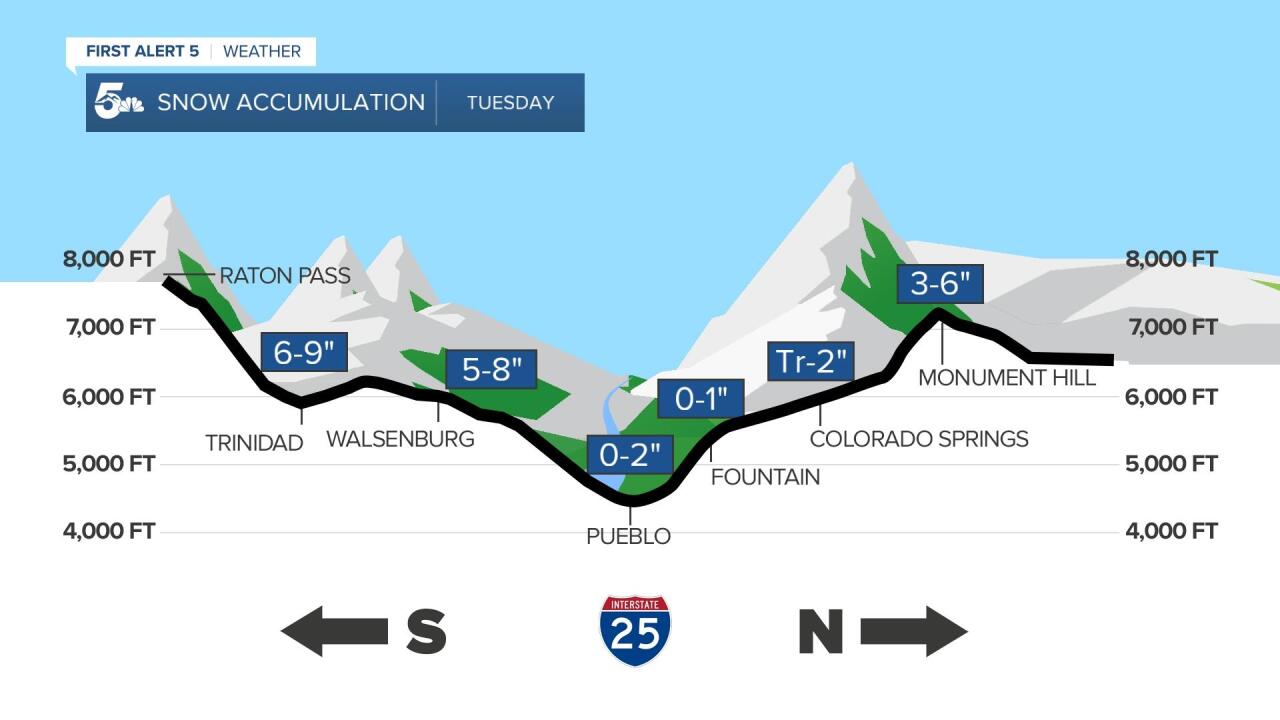
Snow will be very heavy south of Highway 50 in the Wet Mountains, Wet Mountain Valley, Sangre De Cristos, and I-25 from Colorado City through Raton Pass.
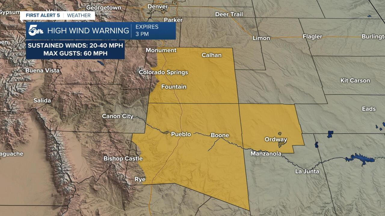
Strong to damaging winds will be possible in El Paso, Pueblo, and Crowley counties with gusts up to 60 mph.
Colorado Springs forecast: High: 41; Low: 23.
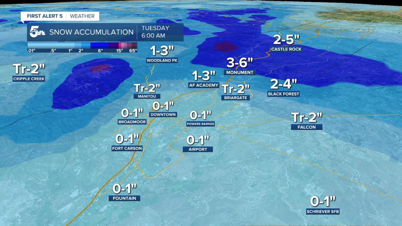
Strong winds are expected in El Paso County with gusts up to 60 mph, which is considered a damaging wind gust. Rain will turn to snow today and while the north end of town could see moderate snow accumulation, most of the city will just see wet to slushy pavement. Heavy snow over the city could still lead to really low visibility even if actual accumulations remain really low.
Tri-Lakes forecast: High: 30s; Low: 10s.
A Winter Weather Advisory is in effect across northern El Paso County for areas like Gleneagle, Monument, Palmer Lake, and Black Forest. These areas have the best chance of seeing over 3 inches of snow today with strong winds leading to very low visibility. Most snow accumulation we see in this area will occur on grassy areas and elevated surfaces because the pavement will be warm enough to keep areas like I-25 wet or slushy.
Pueblo forecast: High: 48; Low: 24.

Strong to damaging wind gusts are possible today with gusts up near 60 mph on the high end. Rain and snow are expected to fall across the Highway 50 corridor today with little to no snow accumulation. What snow we do see from Pueblo to Canon City and east out to La Junta will mainly accumulate in the grass. The heaviest snow with treacherous driving conditions will be southwest into the Wet Mountains and over into the Wet Mountain Valley.
Canon City forecast: High: 46; Low: 27.
Strong winds with a mix of rain and snow will fall across Canon City and the surrounding towns later today. Low visibility as you're driving is the main concern along Highway 50 today with the heaviest snow south of Highway 50 into the mountains. Most of the pavement will stay wet today so what accumulation you do see will be on patio furniture and grassy areas.
Woodland Park forecast: High: 34; Low: 13.
Snow with strong winds will fall across Teller County today with low visibility and low snow accumulation as our two main threats. Warm pavement temperatures will likely keep Highway 24 and 67 wet to slushy today but strong winds could make driving difficult from low visibility. 1 to 3 inches is possible in grassy areas and elevated surfaces.
Plains forecast: High: 40s; Low: 20s.
Strong winds and rain to snow are expected across the plains today with areas of moderate to heavy snow. The heaviest snow today and tonight will collect south of Highway 50 with a wide range of 4 to 8 inches possible through Kim and 2 to 5 inches possible through Springfield. La Junta could see anywhere from 0 to 4 inches and less out near Lamar. Warm pavement could keep most of the snow south of Highway 50 in the grassy areas.
Walsenburg and Trinidad forecast: High: 40s; Low: 10s.

Strong winds and heavy snow through this evening will make travel difficult to impossible in the southeast mountains and southern stretch of I-25. From Colorado City through Trinidad we could see anywhere from 5 to nearly 10 inches of snow, enough that wet and slushy pavement will eventually turn to snow. South through Raton Pass and up into La Veta, Cuchara, and La Veta Pass, we will easily see snow accumulations closer to the foot mark. Strong winds will lead to little to no visibility as snow falls.
Mountains forecast: High: 30s; Low: 10s.
The heaviest snow today will fall over the Wet Mountains and along the southern Sangre De Cristos. Travel will be difficult to impossible west of I-25 into the mountains, so stay home if you can once the snow starts falling.
Extended outlook forecast:
A few snow showers will be possible tomorrow in the upper Pikes Peak Region, but the main story tomorrow will be more strong wind. We should keep warming through the week with windy conditions lasting through Wednesday. We should see temperatures warm into the 60s and 70s over the weekend with even a few 80s possible over the plains.
____
Curious about the First Alert 5 Weather Storm Impact Scale? Check out our cheatsheet explainer.
Watch KOAA News5 on your time, anytime with our free streaming app available for your Roku, FireTV, AppleTV and Android TV. Just search KOAA News5, download and start watching.
