

Tonight's Forecast:
Temperatures will continue to drop this evening into the 30s and 40s across the area. Highs will be much warmer going into Saturday. There will be some lingering moisture from a recent cold front and this will bring a small chance for rain in the afternoon. The best chances for rain will remain in the mountains.
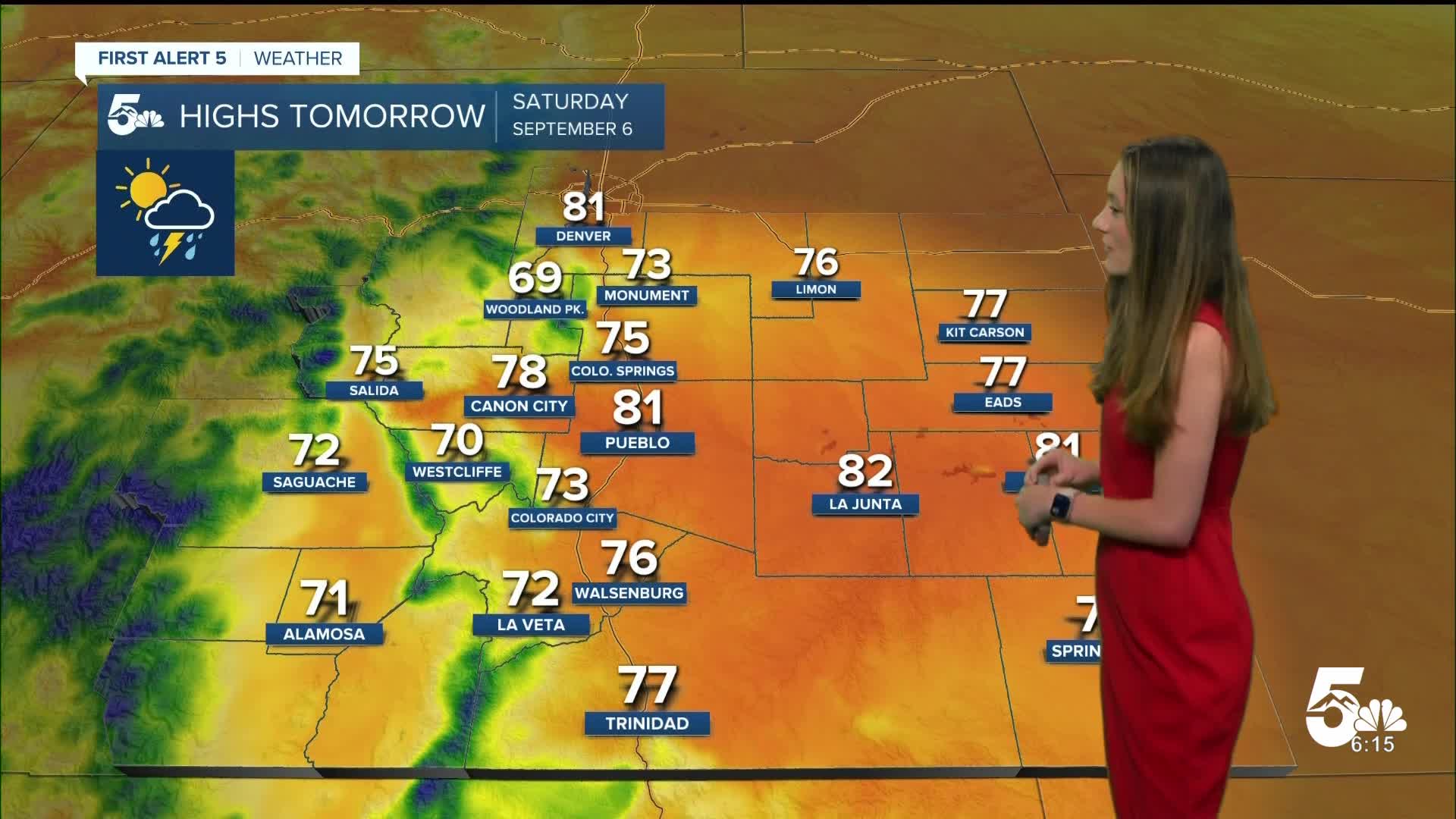
Colorado Springs forecast: Low: 47; High: 75;
There will be some lingering moisture, so some spotty showers are possible Saturday evening. Most of the rain will stay isolated to the mountains. Temperatures are expected to warm into the mid-70s by the afternoon. This is still below average for this time of year.
Pueblo forecast: Low: 48; High: 81;
Pueblo will have their temperatures drop into the upper 40s overnight. A few sprinkles and some clouds will linger, but will move out by morning. The chance of rain will return Saturday afternoon, but will be very hit or miss.
Canon City forecast: Low: 50; High: 78;
Canon City will have clouds linger overnight and this will help to keep the area from getting to cold. Overnight lows will be in the lower 50s. Going into Saturday, temperatures will jump into the upper 70s.
Woodland Park forecast: Low: 38; High: 69;
Woodland Park will get chilly overnight, and morning temperatures will be in the upper 30s. If you have any sensitive plants it would be a good ideas to bring them inside overnight. Highs in the afternoon will warm into the upper 60s.
Tri-Lakes forecast: Low: 44; High: 73;
Monument will have some clouds overnight, but by the morning this will clear out. Temperatures by the afternoon will warm into the lower 70s. Some spotty showers are still possible in the afternoon.
Plains forecast: Low: 40s; High: 70s and 80s;
The plains will have morning lows in the 40s, and there is a chance for some fog early in the morning on Saturday. This will clear out by mid-morning. Temperatures will warm into the 70s and 80s Saturday afternoon.
Walsenburg and Trinidad forecast: Low: 48; High: 76/77;
Walsenburg and Trinidad have the best chances for a few showers Friday evening. Conditions will clear out overnight and temperatures will rise into the upper 70s by the afternoon. There will still be some lingering moisture in the area and rain chances will pick up in the afternoon.
Mountains forecast: Low: 40s; High: 70s;
The mountains will continue with showers this evening. Rain returns throughout the day on Saturday, but will mainly pick up in the afternoon and evening. Temperatures will be in the 70s for the afternoon.
Extended outlook forecast:
Moisture will linger into Sunday as well and there will still be a chance for a shower or two throughout the area. Temperatures will climb a few degrees each day. We will continue to dry out throughout the week from a high-pressure system over the region. The hottest day will be around Wednesday and Thursday.
____
Curious about the First Alert 5 Weather Storm Impact Scale? Check out our cheatsheet explainer.
Watch KOAA News5 on your time, anytime with our free streaming app available for your Roku, FireTV, AppleTV and Android TV. Just search KOAA News5, download and start watching.
