

Tonight's Forecast:
Tonight, temperatures will creep down into the 20s and 30s, which is pretty mild for this time of year. Skies will stay clear overnight and into tomorrow morning.
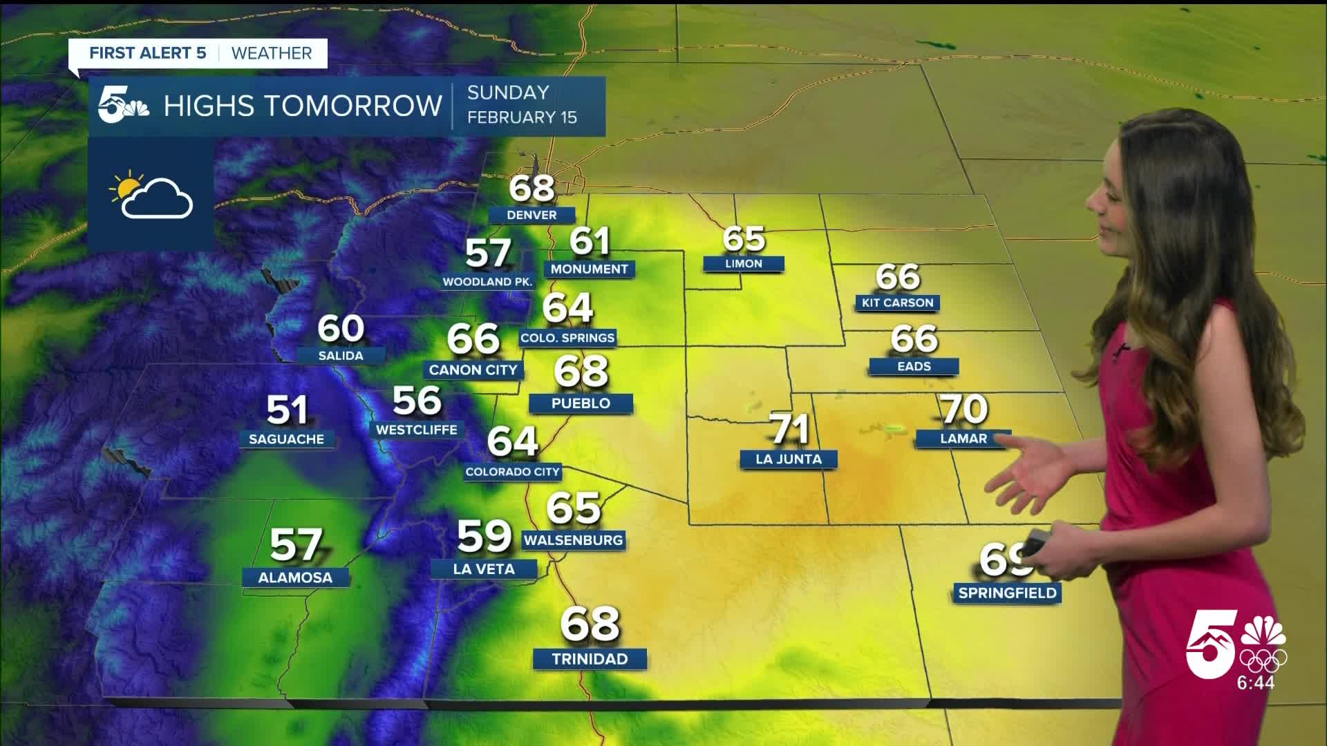
Colorado Springs forecast: Low: 30; High: 64;
For Sunday, we will continue on with the beautiful conditions. The sun will be out and about throughout the day and temperatures will get right back into the mid-60s. Winds will be between 5-15mph.
Pueblo forecast: Low: 24; High: 68;
Pueblo will wake up to temperatures in the mid-20s, but this will warm pretty quickly. By 10am, temperatures will already be in the upper 40s and lower 50s. By the afternoon, highs will have reached the upper 60s. Skies will remain mostly clear throughout the day and winds will be between 5-15mph.
Canon City forecast: Low: 32; High: 66;
Overnight, lows will dip into the lower 30s close to freezing. Skies will be clear overnight and only a few clouds will move in during the day on Sunday. Highs in the afternoon will be in the mid-60s.
Woodland Park forecast: Low: 25; High: 57;
Woodland Park will have overnight temperatures get into the mid-20s. The afternoon will have warm temperatures yet again, and highs will be in the upper 50s. Winds will remain light between 5-15 mph.
Tri-Lakes forecast: Low: 29; High: 61;
The Monument area will have overnight lows in the upper 20s. By the afternoon highs can be expected to reach the lower 60s. There will only be a few clouds during the day, so it will be really nice! Winds will be light.
Plains forecast: Low: 20s; High: 60s & 70s;
The eastern plains will have a chilly morning with lows in the 20s. The afternoon will have some of the warmest temperatures. La Junta and Lamar will both reach the 70s, but the surrounding areas will be in the 60s.
Walsenburg and Trinidad forecast: Low: 30/26; High: 65/68;
The southern I-25 corridor will have morning temperatures in the 20s and 30s. It will be a nice end to the weekend with highs in the mid-to-upper 60s. Winds will be light throughout the day.
Mountains forecast: Low: 20s; High: 50s & 60s;
The mountains will dip into the teens in some areas, but the majority of the higher terrain will be in the 20s. Temperatures will warm quickly and highs will top off in the 50s and 60s.
Extended outlook forecast:
We are gearing up for a busy weather week! A powerful jewstream will park itself over Colorado, and these winds will mix closer to the surface. This means that winds will be strong, especially on Tuesday. The National Weather Service has issued Fire Weather Watches ahead of time for Monday and Tuesday. Please be careful not to create any sparks outside. Fires that start in these conditions will spread very quickly.
For the mountains, snow will start up around Monday and will continue throughout the week. Over a foot of snow is expected for the ski resorts!
____
Curious about the First Alert 5 Weather Storm Impact Scale? Check out our cheatsheet explainer.
Watch KOAA News5 on your time, anytime with our free streaming app available for your Roku, FireTV, AppleTV and Android TV. Just search KOAA News5, download and start watching.
