

Tonight's Forecast:
Temperatures won't be as cold tonight, and lows will get into the 30s and 40s. Winds will stay light during the night and into tomorrow morning. Highs tomorrow will be even warmer than Sunday.
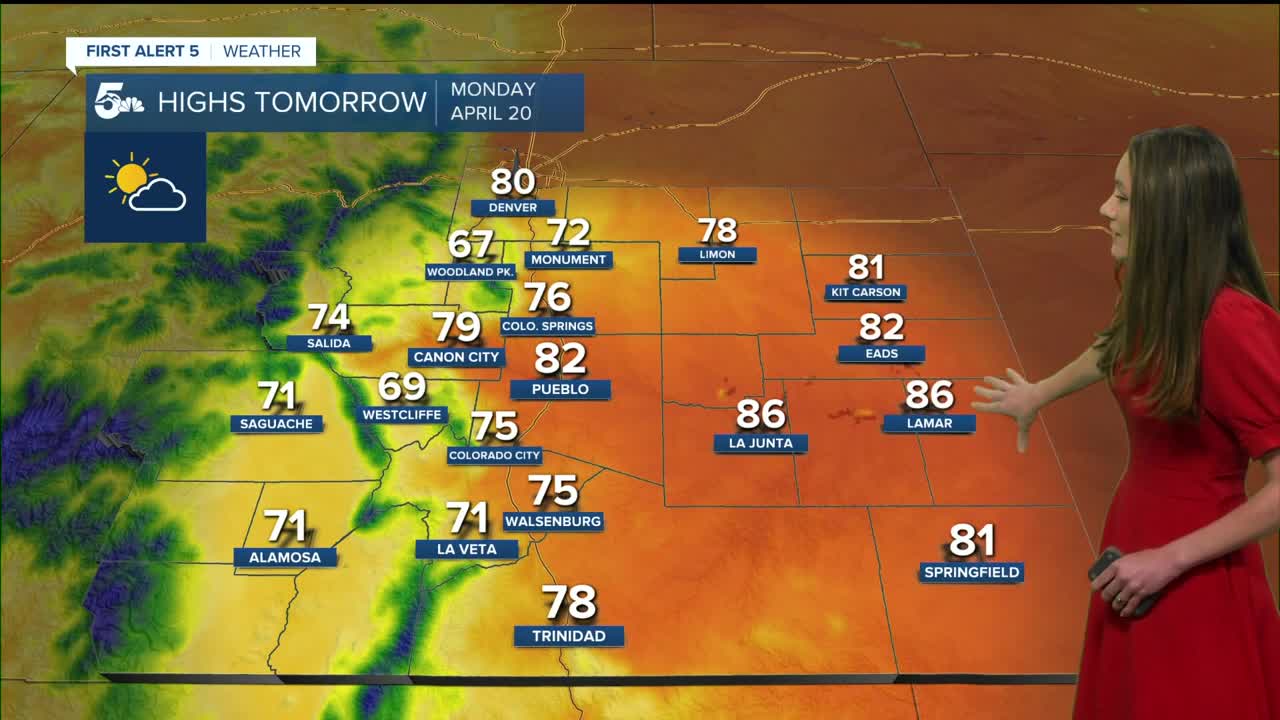
Colorado Springs forecast: Low: 40; High: 76;
The Springs will dip into the lower 40s tomorrow morning with mostly clear conditions overnight and into tomorrow. With this ridge of high-pressure, highs will climb into the mid-70s which is about 15 degrees above normal. Winds will remain light during the day.
Pueblo forecast: Low: 38; High: 82;
Pueblo will have overnight temperature in the upper 30s, and by the time we make it to 10AM temperatures will be in the mid-60s. Afternoon highs will reach the lower 80s. Mostly clear skies will last throughout the day.
Canon City forecast: Low: 41; High: 79;
Morning temperatures will be in the lower 40s. With this ridge continuing to build over top of Colorado, highs in the afternoon will be on the warm side in the upper 70s. Winds will be light, so fire danger won't be a big concern. It will be a very nice day!
Woodland Park forecast: Low: 32; High: 67;
Woodland Park and parts of Teller county will be in the lower 30s. Temperatures won't be quite as cold as Sunday morning. Highs in the afternoon will warm into the upper 60s. Skies will remain mostly clear during the day, so a great day to get outside!
Tri-Lakes forecast: Low: 38; High: 72;
The Monument area will dip into the upper 30s overnight, and by 10AM temperatures will be in the lower 60s. Once we get into the afternoon, temperatures will be in the lower 70s. It will be a nice day to get outside for a hike!
Plains forecast: Low: 30s; High: 80s;
The eastern plains will have lows in the 30s though Baca county will have temperatures in the 40s. Temperatures will warm up quickly, and afternoon highs will be in the mid-80s. Even warmer temperatures are on the way.
Walsenburg and Trinidad forecast: Low: 39; High: 75/78;
The southern portion of I-25 will have overnight lows drop into the upper 30s. A jacket will only be needed in the morning because afternoon temperatures will be in the 70s. Skies will be mostly clear, and winds will remain light.
Mountains forecast: Low: 30s; High: 70s;
The mountains will be chilly overnight, with lows dipping into the 30s. It will be a pleasant day with highs eventually reaching the 60s and 70s. Winds will be light too.
Extended outlook forecast:
This will be an interesting week for weather. The first half of the week will have above average temperatures, and even some places will be close to hitting 90 degrees. Once we get to Wednesday and Thursday, this is when we will start to notice the changes. Highs will drop behind a cold front and rain chances increase for the higher terrain. Next weekend looks the most active with rain possible for I-25 and snow towards the mountains.
____
Curious about the First Alert 5 Weather Storm Impact Scale? Check out our cheatsheet explainer.
Watch KOAA News5 on your time, anytime with our free streaming app available for your Roku, FireTV, AppleTV and Android TV. Just search KOAA News5, download and start watching.
