

Tonight's Forecast:
Clear conditions will continue through the evening and into tonight. Overnight lows will be above average in the 50s for the I-25 corridor. Anyone waiting for a highly anticipated album will have beautiful conditions to go along with it.
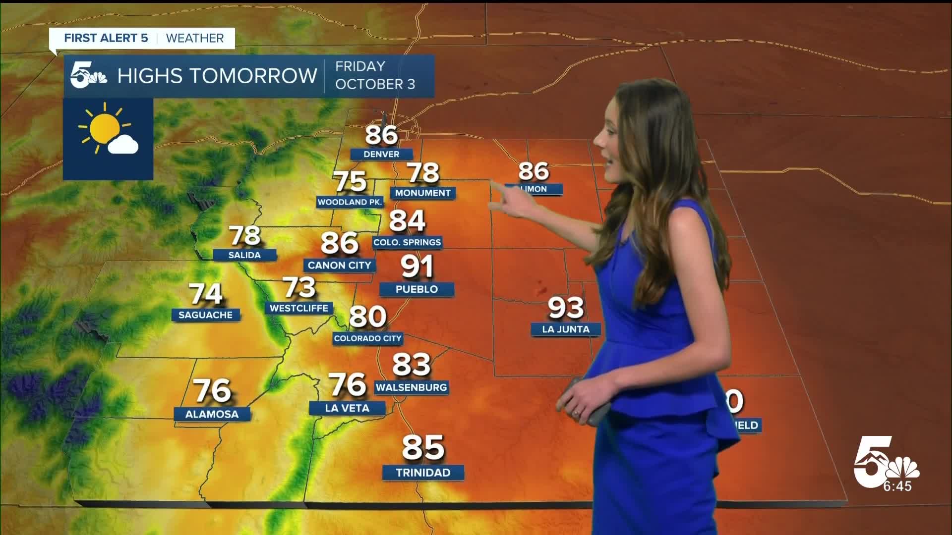
Tomorrow's Forecast:
Temperatures will continue to be above average by about 10 to 15 degrees in some areas. There will be a few more clouds across southern Colorado, but sunshine will still help to warm us up nicely.
Colorado Springs forecast: Low: 52; High: 84;
Colorado Springs will have clear skies waking up with more clouds filtering in throughout the afternoon. Highs by the afternoon will be in the mid-80s. The current daily record is 87 degrees, so we will likely stay below that.
Pueblo forecast: Low: 50; High: 91;
Pueblo will have overnight lows in the lower 50s with afternoon highs well above average in the lower 90s. These temperatures won't last long, though, because once we get into the weekend, we will drop back into the 70s and 80s.
Canon City forecast: Low: 56; High: 86;
Canon City will continue to stay mostly clear going into Friday. Early morning temperatures will be in the mid-50s, so not as cold as our average for this time of year. Afternoon highs will be in the mid-80s.
Woodland Park forecast: Low: 44; High: 75;
Woodland Park will be chilly, but still above normal. 70s will arrive by the afternoon. Enjoy these warmer temperatures because by the time we get to the weekend, they will be in the lower 60s.
Tri-Lakes forecast: Low: 50; High: 78;
Monument will continue to stay mostly clear going into Friday morning. A few clouds will move into the area by the afternoon, but there will still be plenty of sunshine. Highs going into the later part of the afternoon will be in the upper 70s.
Plains forecast: Low: 50s; High: 90s;
The plains will have the warmest temperatures across southern Colorado on Friday with highs reaching the 90s. There will be sunshine throughout the day and conditions will stay dry.
Walsenburg and Trinidad forecast: Low: 52/52; High: 83/85;
Southern I-25 will have morning lows in the lower 50s. With winds coming out of the south throughout the day and plenty of sunshine highs will warm into the ower to mid 80s.
Mountains forecast: Low: 40s; High: 70s;
The mountain peaks will start to have some stronger gusts going into Friday evening. These will pick up overnight going into Saturday as well. Temperatures will be in the 70s across the area.
Extended outlook forecast:
Looking ahead, windy conditions will pick up overnight Friday and into Saturday morning. Wind gusts will be between 40 and 50 mph with some areas even stronger. Winds will die down going into Sunday, and a cold front will push through causing highs to drop into the 60s. The next chance for rain will be on Tuesday.
____
Curious about the First Alert 5 Weather Storm Impact Scale? Check out our cheatsheet explainer.
Watch KOAA News5 on your time, anytime with our free streaming app available for your Roku, FireTV, AppleTV and Android TV. Just search KOAA News5, download and start watching.
